Southeast Alabama, South Georgia, and the Florida Panhandle Are in the Crosshairs for Tornadoes and Damaging Winds Today
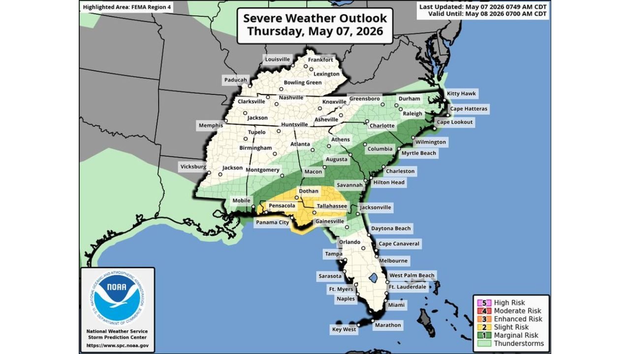
SOUTHEAST ALABAMA — Widely scattered severe storms capable of damaging winds and a couple of tornadoes are possible today, Thursday, May 7, 2026, across southeast Alabama, portions of south Georgia, and north Florida including the Panhandle. The outlook is valid until 7:00 AM CDT on May 8, 2026.
The Highest Risk Zone Today
The Slight Risk area, the most elevated zone on today’s outlook, is centered over a corridor covering Dothan, Alabama, Pensacola, Panama City, and Tallahassee, Florida, and the surrounding communities across the Florida Panhandle and south Georgia border region.
This is where the threat for damaging winds and a couple of tornadoes is most concentrated today.
A Wider Marginal Risk Extends Across the Southeast
A broad Marginal Risk zone surrounds the Slight Risk core and stretches across a much larger area of the Southeast, covering:
- Southeast Alabama including Mobile and Montgomery
- Much of Georgia including Atlanta, Macon, Augusta, and Savannah
- The Carolinas including Charlotte, Columbia, Wilmington, and Myrtle Beach
- Northern Florida including Jacksonville and Gainesville
- Portions of Tennessee including Nashville and Knoxville
Isolated strong to severe storms are possible across all of these areas today.
Additional Threats Beyond the Southeast
Outside the main Southeast risk zone, isolated strong to severe storms are also possible today across:
- The Carolinas
- The lower Rio Grande Valley
- Deep South Texas
Hazards in the Slight Risk Zone
Residents inside the Slight Risk area centered over the Florida Panhandle and southeast Alabama should be prepared for:
- Damaging winds
- A couple of tornadoes
What the Broader Region Faces
Communities across the wider Marginal Risk zone stretching through Georgia, the Carolinas, and northern Florida face the possibility of isolated strong to severe storms capable of gusty winds and brief heavy rain through the validity period ending 7:00 AM CDT Friday May 8.
Stay with CabarrusWeekly.com for continuing updates on today’s severe weather threat across the Southeast.