Minnesota, Illinois, Indiana, Missouri, Colorado, and Oklahoma Face Much Warmer Than Normal Pattern as Major Weather Shift Builds Through End of May Into June
UNITED STATES — A significant shift in the weather pattern is on the horizon heading into the end of May, with a much warmer than normal signal building across the Central Plains and Midwest and a broader warmer than normal pattern spreading across the South and East. The key question heading into the long range is whether this warmth will hold through June.
The Core of the Heat Across the Plains and Midwest
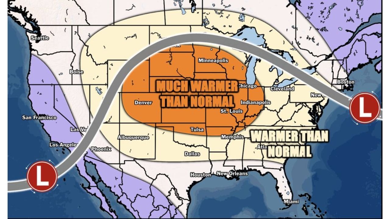
The long-range pattern map shows the strongest above-normal temperature signal concentrated in a broad zone covering the Central and Northern Plains through the Midwest. Cities sitting inside the much warmer than normal core include:
- Minneapolis, Minnesota
- Chicago, Illinois
- Indianapolis, Indiana
- St. Louis, Missouri
- Denver, Colorado
- Tulsa, Oklahoma
This core zone represents the highest departure from normal expected during the end of May through the period covered by this outlook.
A Warmer Than Normal Signal Extends Across the South and East
Surrounding the core warmth, a broader warmer than normal signal covers a wide area stretching from Memphis, Tennessee and Atlanta, Georgia eastward through the Mid-Atlantic and Southeast, with the pattern extending toward New England and Boston, Massachusetts along the eastern seaboard.
The West Stays Cooler and Separate
In sharp contrast to the warmth dominating the central and eastern portions of the country, the Pacific Coast and interior West are shown under a cooler than normal signal, with Seattle, Washington, San Francisco and Los Angeles, California, Las Vegas, Nevada, and Phoenix, Arizona all sitting outside the warm pattern. Two low pressure systems positioned off the West Coast and along the Eastern Seaboard are driving the overall pattern setup.
What This Means for Planting and the Growing Season
The warmth signal arriving across Minnesota, Illinois, Indiana, Missouri, Colorado, and Oklahoma carries significant implications for the remainder of the planting and growing season. Above-normal temperatures across the corn and soybean belt from the Plains through the Midwest during this critical window will accelerate crop development but also increase stress risk if dryness accompanies the warmth.
The Big Question Heading Into June
The long-range update raises the central question of whether this pattern change will be sustained into June or prove to be a shorter-duration warmth event. The answer carries major consequences for agricultural interests, water supply, and summer weather setup across the Central Plains and Midwest.
Stay with CabarrusWeekly.com for continuing updates on the long-range pattern change and its implications through the end of May and into June.