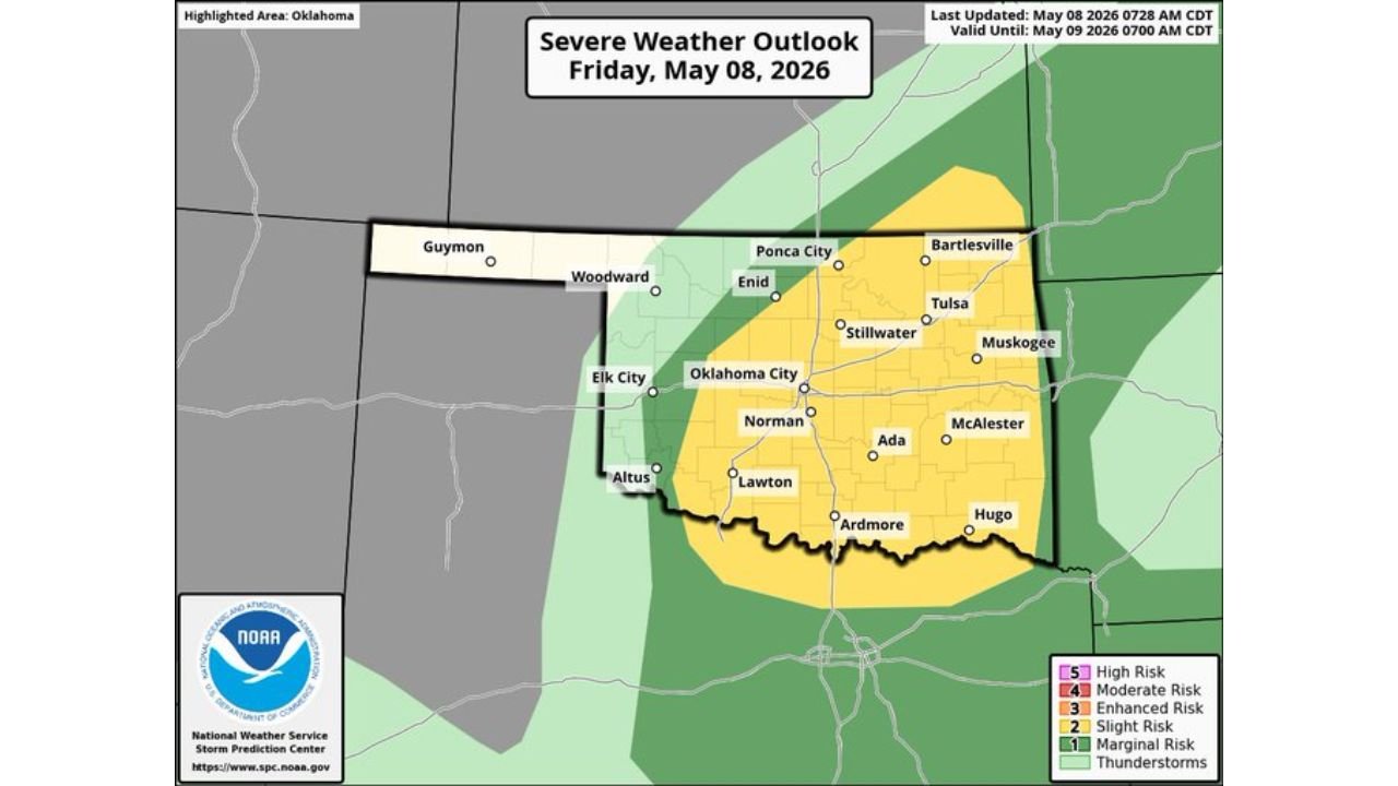
Southeast Kansas, Oklahoma, and North Texas Face Slight Risk of Supercells With Large Hail, Damaging Winds, and Tornado Threat Friday May 8
SOUTHEAST KANSAS, OKLAHOMA, AND NORTH TEXAS — The Storm Prediction Center has outlined a Slight Risk Level 2 of 5 of severe weather across southeast Kansas, much of Oklahoma, and far north Texas on Friday, May 8, 2026, with storms expected to fire along a cold front through the afternoon and evening. The outlook is valid until 7:00 AM CDT on Saturday, May 9, 2026.
The Risk Zone for Friday May 8
The Slight Risk area covers a large portion of Oklahoma from north to south, stretching from Ponca City, Bartlesville, and Enid in the north through Oklahoma City, Stillwater, Tulsa, and Muskogee in the central zone and down through Norman, Lawton, Ardmore, Ada, McAlester, and Hugo in the south. A broader Marginal Risk surrounds the Slight Risk core extending into southeast Kansas and far north Texas.
What Is Driving the Storms Friday
A shortwave trough embedded within a broader northwest flow regime is approaching the area by 4:00 PM today, providing the upper-level support needed to fire storms along the cold front. At the surface, modest moisture return is moving into the region, which will lead to higher-based storms given the limited moisture depth available.
Despite the modest moisture, wind profiles will strongly favor supercell development, making large hail and damaging winds the primary concerns with any storm that fires this afternoon and evening.
Hazards Expected Friday
| Threat | Status |
|---|---|
| Large Hail | Primary Threat — Supercells Favored |
| Damaging Winds | Primary Threat |
| Tornado | Very Low but Nonzero Threat |
Cities Inside the Slight Risk Zone
Residents across the following communities are inside the Slight Risk area for Friday:
- Oklahoma City, Oklahoma
- Tulsa, Oklahoma
- Norman, Oklahoma
- Stillwater, Oklahoma
- Ponca City, Oklahoma
- Bartlesville, Oklahoma
- Muskogee, Oklahoma
- Lawton, Oklahoma
- Ardmore, Oklahoma
- Ada, Oklahoma
- McAlester, Oklahoma
- Hugo, Oklahoma
The Tornado Threat
While tornadoes are not the primary concern Friday, forecasters note that a very low but nonzero tornado threat exists with any supercells that develop. Residents across the Slight Risk zone should not dismiss the tornado threat entirely and should have a way to receive warnings throughout the afternoon and evening hours.
What Oklahoma and Kansas Residents Should Do
With supercell development favored and wind profiles supporting large hail and damaging winds, residents across Oklahoma City, Tulsa, Norman, and the broader Slight Risk zone should remain weather aware through Friday afternoon and evening. Have a reliable way to receive warnings and know your shelter plan before storms develop.
Stay with CabarrusWeekly.com for continuing updates on Friday’s severe weather threat across Oklahoma, Kansas, and north Texas.