Iowa Faces Slight Risk Severe Weather Sunday May 17 With 15 Percent Chance of Storms From Sioux City and Fort Dodge Through Des Moines, Cedar Rapids and Davenport
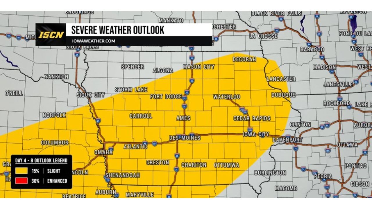
DES MOINES, Iowa — A Slight Risk of severe weather, rated Level 2 out of 5, has been introduced for parts of Iowa on Sunday, May 17, 2026, covering a broad zone from Sioux City and Fort Dodge eastward through Des Moines, Cedar Rapids and Davenport.
This outlook is still 6 days away and details will certainly change, but it is an early sign that a more active weather pattern may return to Iowa this weekend.
Where the 15 Percent Severe Risk Is Outlined
The Slight Risk zone covers a large swath of central and eastern Iowa on Sunday, May 17:
- Sioux City, Iowa sits on the western edge of the 15 percent Slight Risk zone, where the severe weather threat begins as storms push into the state from the west Sunday.
- Storm Lake, Carroll, Fort Dodge and Algona all fall within the highlighted 15 percent zone, placing much of north-central and west-central Iowa at risk for severe storms Sunday, May 17.
- Ames and Des Moines sit near the center of the outlined risk area, where storm coverage and severe weather potential will be among the highest in the state during Sunday’s event.
- Waterloo, Cedar Rapids and Iowa City are included in the eastern portion of the 15 percent zone, meaning the threat extends across nearly the full width of Iowa from west to east.
- Davenport and Dubuque sit near the far eastern edge of the outlined area, where storms pushing through Iowa on Sunday could still carry severe weather potential as they exit the state.
- Ottumwa, Chariton and Atlantic fall within the southern portion of the risk zone, placing south-central Iowa communities inside the Sunday severe weather outlook as well.
What Is a Slight Risk
A Slight Risk is Level 2 out of 5 on the severe weather outlook scale, meaning scattered severe storms are expected rather than isolated or widespread events:
- At the Slight Risk level, multiple severe thunderstorms are expected to affect the outlined area, with damaging winds, large hail and an isolated tornado all possible depending on how the storm system develops by Sunday, May 17.
- This is a step above the Marginal Risk level and indicates forecasters have enough confidence in the setup to highlight Iowa for organized severe weather 6 days in advance, which is noteworthy given how far out the outlook extends.
- Exact timing, storm tracks and the specific threats will become much clearer as Thursday and Friday forecasts are issued closer to the event.
Too Early for Exact Details But Worth Watching
Forecasters are emphasizing that this Sunday, May 17 outlook is still 6 days away and specifics will change:
- It is too early to pin down exact timing or the most likely severe weather impacts for specific Iowa communities like Des Moines, Cedar Rapids or Sioux City at this point in the forecast cycle.
- However, the introduction of a Slight Risk this far in advance signals meaningful confidence that an active weather pattern is returning to Iowa this weekend following the mid-May severe weather stretch already underway.
- Residents across Iowa should monitor daily forecast updates through Friday, May 15 as confidence and storm details will increase significantly in the 48 hours before Sunday’s event.
What Iowa Residents Should Do Now
With 6 days until this threat arrives, Iowa residents have time to prepare thoughtfully:
- Confirm that severe thunderstorm and tornado alerts are enabled on your phone now so any watches or warnings issued Sunday, May 17 reach you immediately regardless of your activity level.
- If you have outdoor plans for Sunday, May 17 across Des Moines, Cedar Rapids, Sioux City or anywhere within the outlined Iowa risk zone, build a severe weather backup plan and identify shelter locations at your destination.
- Check forecast updates daily starting Thursday, May 14 as storm timing and the specific threat types for Sunday will come into much sharper focus by that point.
Cabarrusweekly.com will continue tracking this Slight Risk severe weather outlook across Iowa including Sioux City, Fort Dodge, Des Moines, Cedar Rapids and Davenport and will provide updates as storm details and confidence levels develop ahead of Sunday, May 17.