Wisconsin, Michigan, Illinois and Indiana Face Strong to Severe Storms With 50 mph Wind Gusts, Small Hail and Low-End Tornado Risk Near Green Bay Tuesday May 12 This Evening
GREEN BAY, Wisconsin — A storm system sweeping through the Great Lakes region this evening, Tuesday, May 12, 2026, is bringing strong to locally severe storms with wind gusts of 50 mph or more and small hail across Wisconsin, Michigan, Illinois and Indiana, with a low-end spin-up tornado risk near the Green Bay area.
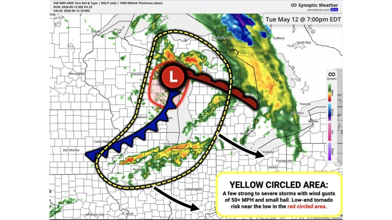
Simulated radar valid at 7:00 PM EDT / 6:00 PM CDT Tuesday, May 12 shows the storm system centered near Green Bay, Wisconsin with a broad shield of rain and storms wrapping through the Great Lakes and pushing southward toward Indianapolis, Indiana through the overnight hours.
Who Faces the Highest Threat This Evening
The yellow circled area on the storm map covers the primary severe weather zone for this evening across the Great Lakes region:
- Wisconsin communities near Green Bay and Wausau sit within the red circled area near the storm’s low pressure center, where the low-end tornado risk is most concentrated this evening. Spin-up tornadoes near a low pressure center can develop quickly and with little warning.
- Michigan communities near Sault Ste. Marie and the Detroit area fall within the broader storm shield shown on the 7:00 PM EDT simulated radar, where strong to severe storms with 50 mph wind gusts and small hail are possible this evening.
- Illinois communities near Chicago, Peoria and Cedar Rapids are included in the yellow circled severe threat zone where wind gusts of 50 mph or more and small hail are the primary concerns through this evening.
- Cleveland, Youngstown and Canton, Ohio are shown on the eastern edge of the storm shield and should monitor conditions through the evening hours as the system tracks eastward.
Indianapolis Overnight Arrival
Storms will reach Indianapolis, Indiana during the early overnight hours but in a weakened form compared to what communities further north are experiencing this evening:
- The storm system is expected to approach Indianapolis in the early overnight hours of Tuesday, May 12 into Wednesday, May 13 in a weakened fashion, meaning the severe weather threat will be lower for Indianapolis than for Green Bay and Chicago during the peak evening hours.
- Residents in Indianapolis and surrounding Indiana communities should still expect showers and storms to arrive overnight and should keep weather alerts active through the early morning hours of Wednesday, May 13.
What 50 mph Wind Gusts Can Do
Wind gusts of 50 mph are strong enough to cause meaningful damage across Wisconsin, Michigan, Illinois and Indiana this evening:
- Gusts at 50 mph can snap tree branches, knock over unsecured outdoor furniture and objects, and down power lines across the Great Lakes region during this evening’s storm passage.
- Small hail accompanying these storms can cause minor vehicle damage and create slippery road conditions very quickly, particularly near Green Bay, Wausau and Chicago where storm coverage will be highest this evening.
- The low-end tornado risk near Green Bay and the low pressure center means residents in that area should be prepared to take immediate shelter if a tornado warning is issued this evening.
Safety Actions for Tonight
Residents across Wisconsin, Michigan, Illinois and Indiana should take the following steps before storms arrive this evening:
- Keep weather alert notifications active on your phone through the entire evening of Tuesday, May 12 and into the overnight hours, especially if you are in Indianapolis where storms arrive later.
- If you are near Green Bay, Wisconsin treat this as an imminent tornado threat and identify your shelter location now before storms arrive this evening.
- Bring all loose outdoor items inside before 7:00 PM CDT across Wisconsin and Illinois as 50 mph wind gusts can turn unsecured objects into dangerous projectiles.
Cabarrusweekly.com will continue tracking strong to severe storms, 50 mph wind gusts and the low-end tornado risk across Wisconsin, Michigan, Illinois and Indiana including Green Bay, Chicago and Indianapolis and will provide updates as storm timing and tornado threat details develop through Tuesday, May 12 evening.