Florida Faces Increasing Supercell and Isolated Tornado Risk From Tampa and Orlando Through Kissimmee, Bradenton and Palm Bay Between 1:00 PM and 5:00 PM Tuesday May 12
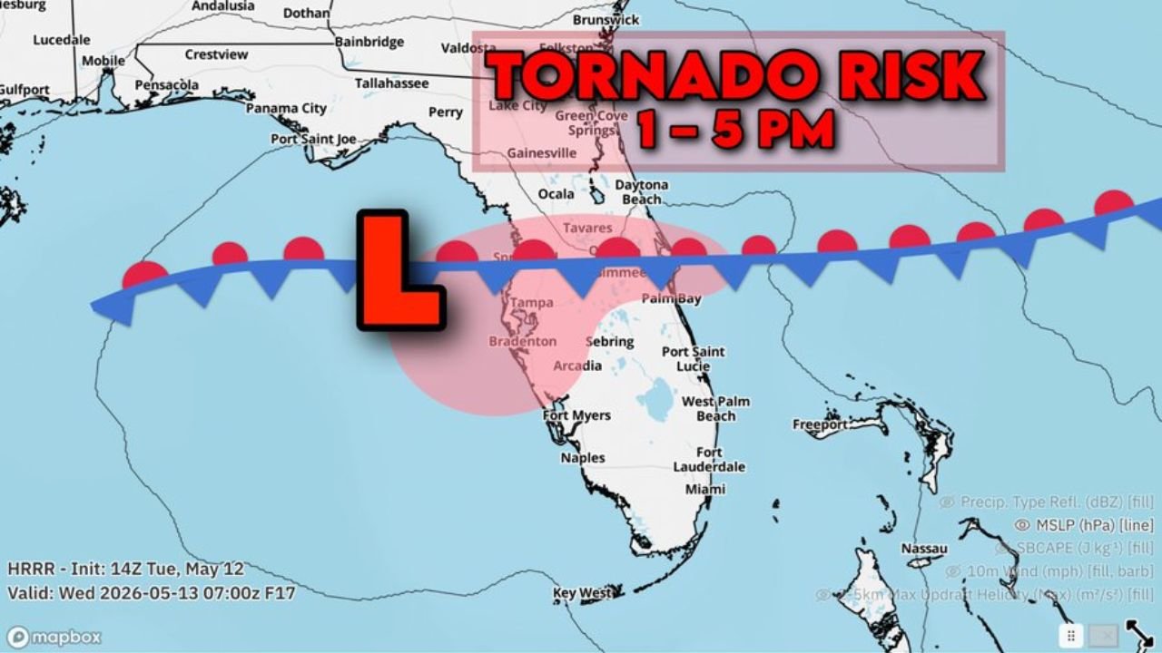
TAMPA, Florida — Central Florida including both the Tampa and Orlando areas face an increasing supercell and isolated tornado risk between 1:00 PM and 5:00 PM this afternoon, Tuesday, May 12, 2026, with the core threat zone centered across a broad area from Bradenton and Tampa northeastward through Kissimmee, Tavares and Palm Bay.
A low pressure system tracking directly across central Florida this afternoon is the primary driver of the tornado risk, with the most dangerous window running from 1:00 PM through 5:00 PM.
Who Is at Risk Between 1 PM and 5 PM
The tornado risk zone shown on the map covers a large portion of central Florida during the 1:00 PM to 5:00 PM window:
- Tampa, Florida and Bradenton, Florida sit on the western edge of the core tornado risk zone, where the low pressure system tracking eastward will be closest to the surface and most capable of producing supercell thunderstorms and isolated tornadoes this afternoon.
- Kissimmee, Florida and Tavares, Florida fall near the center of the outlined tornado risk area, placing these communities in the highest-exposure zone between 1:00 PM and 5:00 PM Tuesday.
- Orlando, Florida is included in the increasing tornado risk zone and residents across the metro area should be prepared to take immediate shelter if a tornado warning is issued during the 1:00 PM to 5:00 PM timeframe.
- Palm Bay, Florida sits on the eastern edge of the risk zone along the Atlantic coast, where the tornado threat extends through the afternoon hours as storms push eastward across the peninsula.
- Sebring, Florida and Arcadia, Florida fall within the southern portion of the risk area and should maintain weather awareness through the full 1:00 PM to 5:00 PM window.
- Daytona Beach, Florida and Ocala, Florida sit near the northern fringe of the outlined zone and face a lower but real isolated tornado risk during this afternoon’s event.
What Is Driving This Tornado Risk
A low pressure system is the engine behind today’s central Florida tornado threat:
- Low pressure systems create rotating wind patterns near the surface that can trigger supercell thunderstorms, which are the type of storms most capable of producing tornadoes. When a low pressure center tracks directly over a warm and moist region like central Florida in May, the tornado risk increases significantly.
- The front associated with this low pressure system is positioned to drag directly across Tampa, Kissimmee and Palm Bay during the 1:00 PM to 5:00 PM window, which is precisely when storm rotation and tornado potential will be highest across the region.
- Supercell thunderstorms that form along and near this front can produce isolated tornadoes with relatively little warning, making the 1:00 PM to 5:00 PM window a period where residents must stay weather-alert ready at all times.
What to Do Right Now
Anyone in Tampa, Orlando, Kissimmee, Bradenton, Palm Bay, Tavares, Sebring or Arcadia must take action before 1:00 PM today:
- Identify your shelter location right now. An interior room on the lowest floor of a sturdy building away from all windows is your safest option if a tornado warning is issued between 1:00 PM and 5:00 PM.
- If you are in a mobile or manufactured home anywhere within the central Florida tornado risk zone, make arrangements to shelter in a nearby sturdy permanent structure before 1:00 PM today. Mobile homes offer no protection from a tornado.
- Keep weather alert notifications active and your phone volume on throughout the entire 1:00 PM to 5:00 PM window. Tornado warnings in central Florida can be issued with very short lead times when a low pressure system is directly overhead.
After 5 PM
The tornado risk window is focused on 1:00 PM through 5:00 PM for central Florida today. Conditions are expected to gradually change after 5:00 PM as the low pressure system moves eastward away from the core risk zone, but residents should continue monitoring weather alerts through the early evening hours of Tuesday, May 12 until the system fully clears the area.
Cabarrusweekly.com will continue tracking this supercell and isolated tornado risk across central Florida including Tampa, Orlando, Kissimmee, Bradenton and Palm Bay and will provide updates as tornado warnings and storm activity develop between 1:00 PM and 5:00 PM Tuesday, May 12.