Indiana, Ohio and Kentucky Face Heavy Rain Risk South of I-70 Near Indianapolis, Cincinnati and Louisville as Surface Boundary and Low Level Jet Collide Saturday May 16 This Afternoon
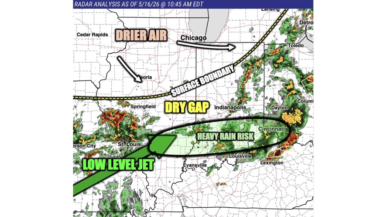
INDIANAPOLIS, INDIANA — A surface boundary carrying drier air is slowly sagging southward across northern Indiana and northern Illinois this Saturday afternoon May 16, 2026, limiting storm development north of I-70 while setting up the most widespread rain and storm activity to redevelop south of I-70 where the surface boundary and unstable air mass collide. A low level jet pushing moisture northward is fueling a heavy rain risk across the corridor from St. Louis through Indianapolis, Cincinnati, and Louisville.
Where the Rain and Storm Risk Is Focused
Radar analysis as of 10:45 AM EDT on May 16, 2026 shows the setup clearly defined:
- Heavy rain risk zone centered over Indianapolis, Cincinnati, Dayton, and Louisville
- Low level jet pushing moisture northeast from the St. Louis area into the heavy rain corridor
- Dry gap sitting over central Indiana keeping activity more scattered near Indianapolis
- Drier air from the north suppressing activity across Chicago, Peoria, and northern Illinois and Indiana
- Active storm cells already firing along the surface boundary from Dayton to Columbus and Cincinnati
Indy 500 Qualifying Watch
A drier gap is expected to provide a window near Indianapolis, making Saturday qualifying a very close call weather-wise. The current setup favors more scattered rather than widespread activity near the track, but the situation remains uncertain through the afternoon.
North of I-70 Stays Drier
Northern Indiana and northern Illinois will see limited storm development this afternoon as the drier air mass keeps conditions mostly suppressed north of the I-70 corridor. The main action stays focused to the south and east.
Stay with CabarrusWeekly.com for live updates as this Saturday afternoon rain and storm setup evolves across Indiana, Ohio, and Kentucky.