Great Plains and Midwest Stare Down a Moderate Risk Severe Weather Outbreak Monday With Giant Hail, 85 MPH Winds, and Violent Tornadoes on the Way
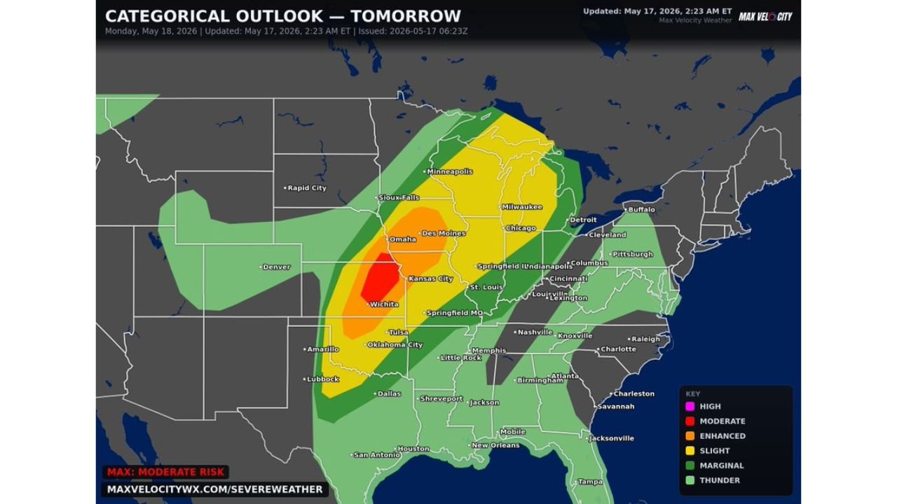
UNITED STATES — A Moderate Risk of severe weather has been issued for Monday, May 18, 2026, targeting the Great Plains and Midwest in what forecasters are calling a dangerous severe weather outbreak. The threat includes giant hail up to 3 to 4 inches or larger, damaging winds of 60 to 85 mph, and strong to intense EF-3 or stronger tornadoes. This outlook was updated at 2:23 AM ET on Sunday, May 17, 2026, and confidence in a major event continues to grow.
The Moderate Risk Zone Is the Bullseye for Monday
The Moderate Risk sits directly over the Wichita and Kansas City corridor, making this area the highest concentration of danger heading into Monday. This is the zone where all three major threats, violent tornadoes, giant hail, and destructive winds, are most likely to converge. Forecasters warn this threat zone could still expand further as confidence increases throughout the day Sunday.
How Monday’s Storm Outbreak Will Unfold
Forecasters are describing a two-phase severe weather event for Monday. In the first phase, discrete supercells will dominate across Kansas, Nebraska, and Iowa. These isolated storms are the most efficient tornado and giant hail producers, and this is the window when the EF-3 or stronger tornado threat is highest.
As the event progresses, those storms are expected to upscale into a large line of thunderstorms. Once that happens, the threat shifts toward widespread damaging winds and embedded tornadoes as the main concerns across the broader region.
A Full Breakdown of Every Risk Zone
| Risk Level | Cities and Areas |
|---|---|
| Moderate | Wichita, Kansas City |
| Enhanced | Omaha, Des Moines, Tulsa, Oklahoma City |
| Slight | Minneapolis, Milwaukee, Chicago, Indianapolis, St. Louis, Springfield MO, Memphis, Little Rock |
| Marginal | Detroit, Cleveland, Cincinnati, Nashville, Dallas, Shreveport |
| Thunder | Broader surrounding region |
The Three Threats Every Resident Must Know
- Giant hail measuring 3 to 4 inches or larger capable of destroying vehicles, roofs, and crops
- Damaging winds of 60 to 85 mph with the potential for widespread structural damage
- EF-3 or stronger tornadoes during the discrete supercell phase over Kansas, Nebraska, and Iowa
Time Is Running Out to Prepare
With the outbreak arriving Monday, Sunday is the last full day residents across the threat zone have to get ready. Know your nearest storm shelter, make sure all weather alert systems are active, and have a plan that covers both the tornado phase and the damaging wind phase of this event. Do not wait until storms are on the radar to act.
Stay with CabarrusWeekly.com for live coverage and continuous updates as this dangerous Monday outbreak approaches.