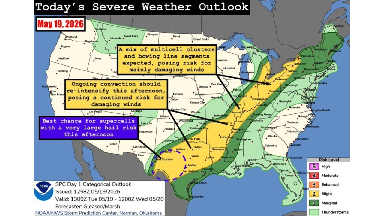
Supercells With Very Large Hail and Damaging Winds Targeting West and Southwest Texas Including Lubbock Abilene and Wichita Falls While Line Storms Fire Damaging Wind Threat From Missouri to the Great Lakes Tuesday May 19
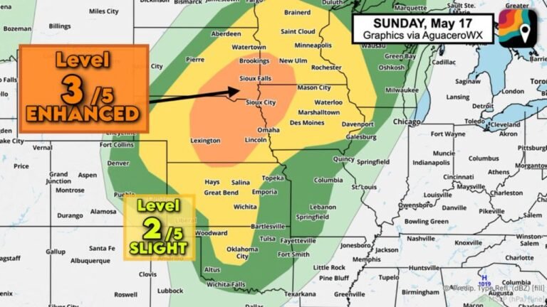
UNITED STATES — The Storm Prediction Center has maintained an expansive Slight Risk of severe weather stretching from the Great Lakes all the way to the Texas-Mexico border on Tuesday, May 19, 2026, with three distinct threat areas each carrying their own set of dangers through the afternoon and evening hours. The outlook was issued at 1258Z and is valid through 1200Z Wednesday, May 20.
Three Separate Threat Areas Are Active Today
This is not a single-corridor event. Forecasters have identified three distinct zones of severe weather concern developing simultaneously across a massive portion of the country today.
Missouri to Texas: Ongoing Storms Re-Intensifying This Afternoon
Convection that has been ongoing from Missouri to Texas is expected to re-intensify this afternoon, maintaining a continued and dangerous risk for damaging winds across this corridor. Residents from Missouri southward through Oklahoma, Arkansas, and into Texas should expect storm activity to ramp back up through the afternoon hours.
Midwest and Great Lakes: Damaging Wind Threat From Line Storms
Across the Midwest and Great Lakes region, a mix of multicell clusters and bowing line segments is expected to develop this afternoon. The primary threat from this activity is damaging winds, with the storm mode favoring organized line segments capable of producing widespread wind damage across a large geographic area.
West and Southwest Texas: Supercells With Very Large Hail
The most intense storm type today will be found in west and southwest Texas, where conditions favor the development of robust supercells during the afternoon hours. These storms carry the best chance for very large hail and damaging winds before they are expected to morph into a line by evening. Anyone in western and southwestern Texas should be prepared for significant hail impacts this afternoon.
Full Risk Zone Breakdown for Today
| Risk Level | Coverage |
|---|---|
| Slight (2/5) | Great Lakes to Texas-Mexico border |
| Marginal (1/5) | Broader surrounding corridor |
| Thunderstorms | Widest coverage area |
What Residents Across This Entire Zone Need to Know
With three active threat zones firing simultaneously today, the severe weather footprint is enormous. The primary threats across the full Slight Risk area include:
- Damaging winds from ongoing convection and line storms
- Very large hail from supercells in west and southwest Texas
- Widespread storm coverage from the Great Lakes to the Texas-Mexico border
Stay with CabarrusWeekly.com for continuous updates as today’s severe weather develops across this expansive threat zone.