Supercells Targeting Dallas Abilene and San Angelo With 2 to 3 Inch Hail Late Tuesday as 15 Percent Hail Probability Zone Fires Across West and Central Texas
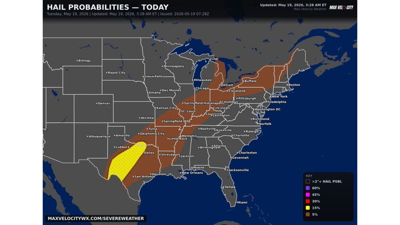
TEXAS — Supercell thunderstorms capable of producing hail 2 to 3 inches in diameter are on the way for Dallas, Abilene, and San Angelo late Tuesday, May 19, 2026. The hail probability map, updated at 3:28 AM ET, shows a 15 percent hail probability zone with 2 inch or larger hail possible centered directly over the west and central Texas corridor. Residents in these areas need to protect vehicles and property before storms arrive.
The Hail Threat Is Concentrated and Serious
A 15 percent probability zone with 2 inch or larger hail hatching sits directly over the Dallas, Abilene, San Angelo, and Lubbock corridor in west and central Texas. This is the area carrying the highest concentration of large hail risk today. Supercells developing in this zone this afternoon and evening are capable of producing golf ball to baseball-sized hail, which is large enough to shatter windshields, dent vehicles, and damage roofs.
A Broader 5 Percent Hail Zone Covers the Eastern United States
Beyond the Texas core, a 5 percent hail probability zone spreads across an enormous portion of the country, covering:
- Oklahoma City and Tulsa, Oklahoma
- Kansas City and St. Louis, Missouri
- Memphis and Nashville, Tennessee
- Chicago, Indianapolis, and Columbus
- Pittsburgh, Cleveland, and Detroit
- New York, Philadelphia, and Washington D.C.
- Charlotte, Atlanta, and Birmingham
- Boston and Buffalo
While the hail threat in these areas is far lower than the Texas core, any storms that develop within the 5 percent zone are still capable of producing hail up to 2 inches in diameter.
When Dallas, Abilene, and San Angelo Need to Be Ready
The primary hail threat for the Dallas, Abilene, and San Angelo corridor arrives late today as supercells develop during the afternoon and evening hours. This gives residents time to act now. Move vehicles into garages or covered parking, secure outdoor furniture, and have a plan ready before storms approach.
Protecting Your Property Before Storms Arrive
Hail measuring 2 to 3 inches is capable of causing thousands of dollars in damage to unprotected vehicles in minutes. Anyone in the west and central Texas zone should treat this afternoon as an urgent window to get vehicles under cover before storms develop.
Stay with CabarrusWeekly.com for live hail and storm updates throughout Tuesday afternoon and evening.