Vigorous Cold Front Targeting Washington DC Baltimore Philadelphia and New York With Damaging Winds and 1 Inch Hail Between 3 and 9 PM Wednesday Before Temperatures Crash From 90s to Upper 60s
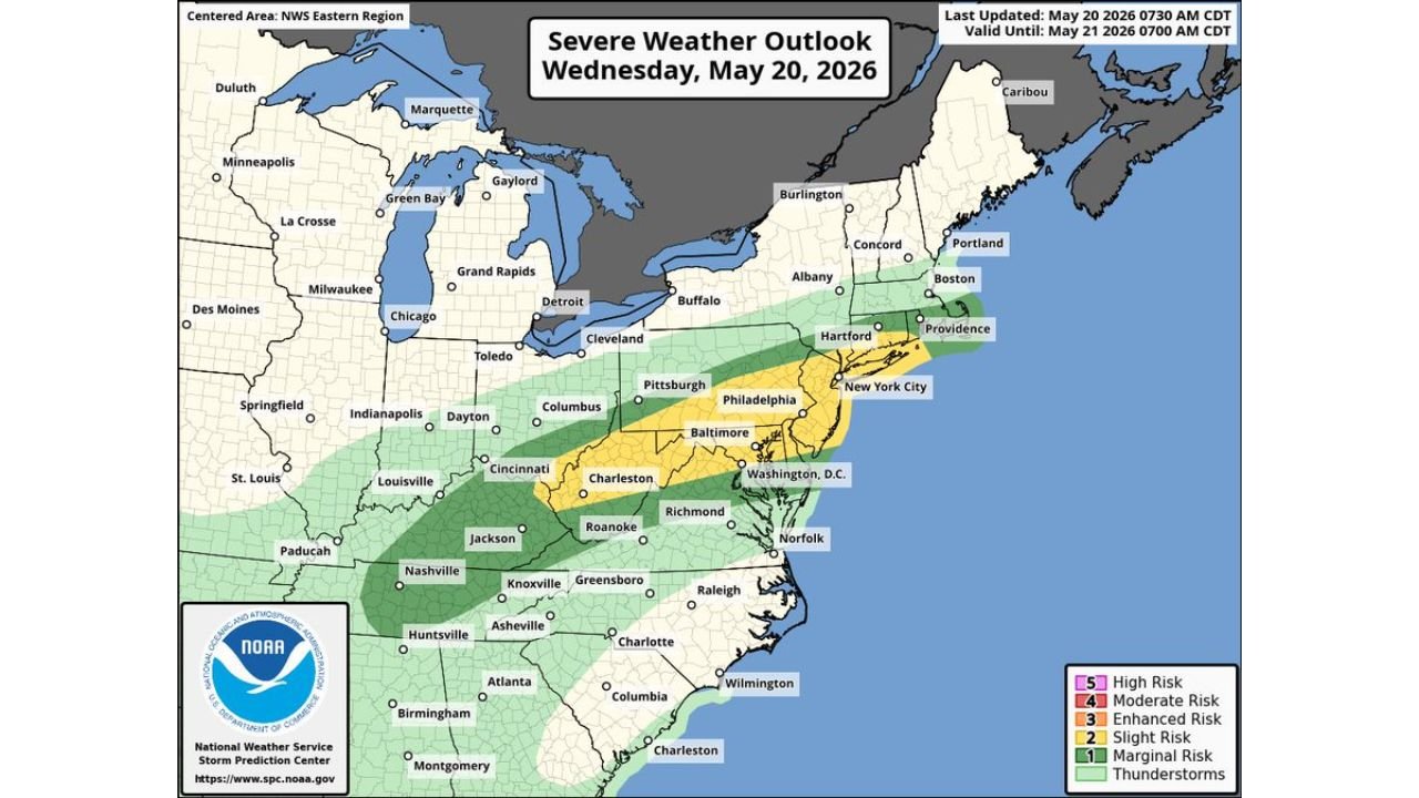
WASHINGTON D.C. — A vigorous cold front is sweeping through the Washington D.C. area and surrounding Mid-Atlantic region this Wednesday afternoon and evening, May 20, 2026, setting off strong to severe thunderstorms and bringing an abrupt end to the record-breaking heat that has gripped the region. The National Weather Service has placed the area in a Level 2 out of 5 Slight Risk zone for severe storms.
Storm Timing You Need to Know Right Now
The storm window is specific and actionable. Residents across the corridor should plan around these times:
| Area | Peak Storm Window |
|---|---|
| West to east corridor | 3:00 PM to 9:00 PM |
| Beltway area | 4:00 PM to 7:00 PM (highest chance) |
| Beltway northward | Most numerous storm coverage |
| South of the Beltway | More scattered coverage |
The Four Threats Coming With These Storms
Every storm cell moving through this afternoon has the potential to produce:
- Damaging wind gusts
- Large hail up to 1 inch in diameter
- Heavy lightning
- Downpours of 0.25 inches on average with heaviest cells dropping 1 inch or more
Storms are expected to draw significant energy from the steamy and unstable air already in place from the record heat, meaning they could become especially intense as the cold front pushes through during peak afternoon heating hours.
How Long Each Storm Will Last
The good news is that individual storm cells are expected to move through swiftly, passing most locations in 30 to 60 minutes. However, the overall threat window stretches from 3:00 PM through 9:00 PM, meaning multiple rounds are possible for some communities.
The Full Risk Zone for Wednesday
| Risk Level | Cities and Areas |
|---|---|
| Slight (2/5) | Washington D.C., Baltimore, Philadelphia, New York City, Hartford, Providence |
| Marginal (1/5) | Pittsburgh, Columbus, Cincinnati, Charleston WV, Richmond, Norfolk, Roanoke, Nashville, Knoxville, Charlotte |
| Thunderstorms | Wide surrounding coverage |
Temperatures Will Crash After Storms Pass
One silver lining to today’s storm threat is what follows. Once the cold front clears through, temperatures will drop rapidly from the 90s down to the upper 60s and 70s, ending the dangerous heat event that has impacted the region over recent days.
A Severe Thunderstorm Watch May Be Issued
The National Weather Service has indicated that a severe thunderstorm watch may be issued for portions of the affected zone as storms develop this afternoon. Residents across the Slight Risk area should keep weather alerts active on all devices throughout the afternoon and evening hours.
Stay with CabarrusWeekly.com for live storm updates and warnings as this cold front sweeps through the Mid-Atlantic Wednesday afternoon.