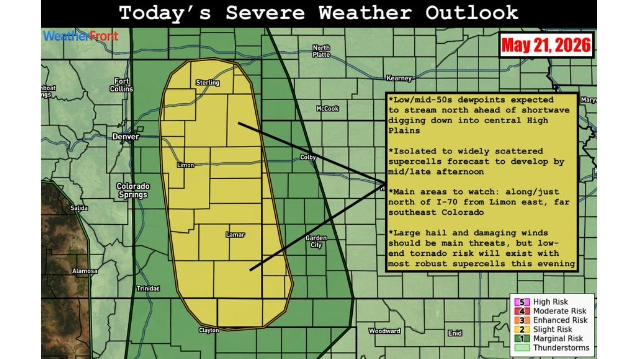
Eastern Colorado Supercells Targeting Sterling Limon and Lamar With Large Hail Damaging Winds and Low-End Tornado Risk Along Interstate 70 Corridor Thursday May 21 Afternoon and Evening
EASTERN COLORADO — Isolated to widely scattered supercell thunderstorms are forecast to develop across eastern Colorado by mid to late afternoon on Thursday, May 21, 2026, pushing into a Slight Risk zone centered over the eastern plains and bringing threats of large hail, damaging winds, and a low-end tornado risk as moisture continues to increase through the evening hours.
The Primary Area to Watch Today
Forecasters have identified a specific corridor as the highest priority watch zone for today’s event. The main focus area runs along and just north of Interstate 70 from Limon eastward, extending into far southeast Colorado. The communities of Sterling, Limon, and Lamar sit directly inside the Slight Risk zone and will be the most exposed to organized supercell activity as storms develop this afternoon.
What Is Setting Up Thursday’s Storm Threat
Two key atmospheric ingredients are coming together over eastern Colorado today:
- Low to mid-50s dewpoints streaming northward ahead of a shortwave trough digging down into the central High Plains
- Increasing moisture through the afternoon and evening hours fueling more robust storm development
As storms mature through the evening, the combination of rising moisture and atmospheric instability will increase the potential for the most organized and dangerous supercell activity of the day.
The Three Threats With Today’s Supercells
| Threat | Level |
|---|---|
| Large hail | Primary threat |
| Damaging winds | Primary threat |
| Tornadoes | Low-end risk with most robust supercells this evening |
While large hail and damaging winds are the headline threats for today, forecasters are clear that a tornado cannot be ruled out with the strongest supercells developing this evening as moisture continues to stream into the area.
The Timing Residents Need to Know
- Mid to late afternoon: Isolated to scattered supercells begin developing across eastern Colorado
- Evening hours: Moisture increase supports more robust supercell development, elevating the tornado risk with the strongest storms
What Eastern Colorado Residents Must Do Now
Anyone living across the Slight Risk zone from Sterling through Limon and south to Lamar should have weather alerts active and a shelter plan ready before storms develop this afternoon. Supercells can produce large hail with little warning time, and any storm showing rotation this evening should be treated as a serious tornado threat.
Stay with CabarrusWeekly.com for live storm updates across eastern Colorado throughout Thursday afternoon and evening.