Alabama Faces Heavy Rain, Marginal Risk Storms, and a Warming Trend Through May 11 as South Alabama Sees Over 5 Inches This Week
ALABAMA — A band of showers and thunderstorms is tracking across the US-80 corridor in South Alabama on Saturday, May 9, 2026, bringing additional heavy rain to an area that has already recorded over 5 inches of rainfall this week from Selma to Montgomery. The northern half of the state remains rain-free. A three-day outlook through Monday May 11 shows the storm threat gradually ending before a warming trend pushes temperatures into the low 90s by May 17 to 20.
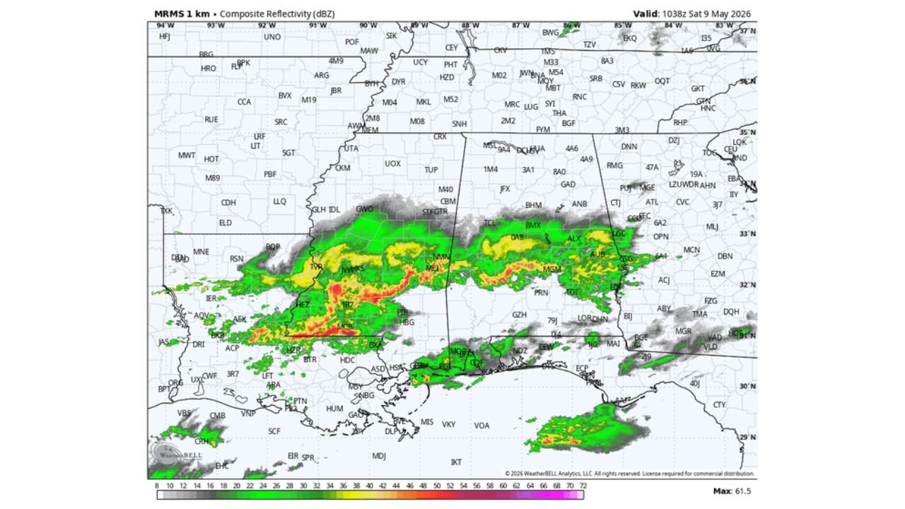
What Radar Shows Saturday Morning
MRMS composite reflectivity valid at 1038Z Saturday May 9 shows a well-organized band of moderate to heavy rain stretching across central and south Alabama along the US-80 corridor, with the highest intensity returns concentrated between Selma, Montgomery, and Birmingham. The radar confirms:
- Heavy rain continuing from Selma through Montgomery
- Active showers across central Alabama into the Birmingham corridor
- Northern Alabama remaining rain-free
Saturday Forecast: South Alabama Stays Wet, North Stays Dry
Periods of rain will continue across South Alabama through the day Saturday while North Alabama stays generally dry with only a few small isolated showers possible around this evening. High temperatures Saturday are expected to range between 75 and 82 degrees statewide.
The Saturday severe weather outlook valid until 7:00 AM CDT Sunday May 10 shows the southern half of Alabama under a Marginal Risk Level 1 of 5, covering communities from Montgomery, Greenville, and Troy southward through Dothan and Mobile.
Sunday Forecast: Scattered Storms Develop Late
Much of Sunday will be dry with temperatures reaching the low 80s before scattered showers and storms develop late in the afternoon and Sunday night ahead of an approaching cold front.
The Sunday severe weather outlook valid until 7:00 AM CDT Monday May 11 places the southern half of Alabama under a Marginal Risk, covering the same general corridor from Montgomery southward through Dothan and Mobile. A few thunderstorms could produce:
- Gusty winds
- Hail
- No tornado risk
Monday: Storms End, Dry Air Returns
Showers and storms are expected to end Monday morning as dry air rolls into Alabama during Monday afternoon. The Monday severe weather outlook valid until 7:00 AM CDT Tuesday May 12 shows a diminishing Marginal Risk across the southern portions of the state as the cold front pushes through.
The Week Ahead: Dry and Warming
The rest of the week after Monday looks dry with a warming trend building across Alabama. Long range guidance indicates temperatures will reach the low 90s across Alabama by May 17 to 20 as an upper ridge begins to build across the region.
Three-Day Outlook Summary
| Day | Conditions | Severe Risk | High Temps |
|---|---|---|---|
| Saturday May 9 | Heavy rain south, dry north | Marginal: South Alabama | 75 to 82°F |
| Sunday May 10 | Dry morning, storms late | Marginal: South Alabama | Low 80s |
| Monday May 11 | Storms end morning, dry afternoon | Marginal fading | Warming |
Stay with CabarrusWeekly.com for continuing updates on Alabama’s rain and storm threat through Monday and the warming trend ahead.