Abilene, Dallas, Austin, Houston, and San Angelo Face Widespread Severe Thunderstorms Sunday May 10 With Softball Size Hail, Tornadoes, and 65 MPH Winds
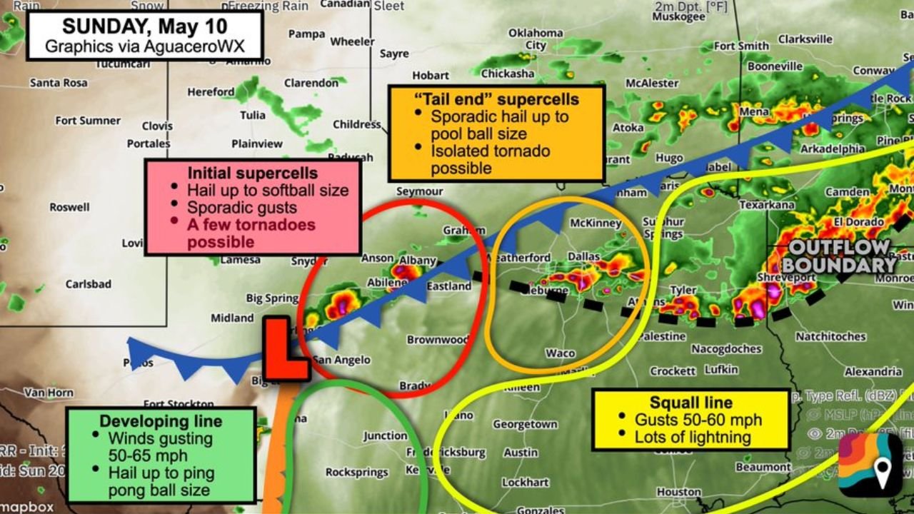
TEXAS — Widespread strong to severe thunderstorms are expected across a large portion of Texas on Sunday, May 10, 2026, as ample humidity and warmth combine with a cold front sagging southward to create significant instability across the state. Four distinct storm zones have been identified, each carrying different storm modes and hazards ranging from squall line winds of 50 to 60 MPH in the east to softball-sized hail and tornadoes in the west.
The Four Storm Zones for Sunday May 10
Red Zone: Anson, Abilene, Graham, Brownwood, Brady, San Angelo, and Eastland
The most dangerous zone Sunday sits near the triple point of low pressure where the cold front and dryline intersect west of the I-35 corridor. This area carries the highest severe weather potential with:
- Initial supercells developing during the afternoon
- Large damaging hail up to softball size with the strongest supercells
- Sporadic damaging wind gusts
- A couple of tornadoes possible during the supercell phase
Storms in this zone may eventually merge into windy lines and clusters with a lesser hail and tornado risk as the evening progresses.
Orange Zone: Dallas, Fort Worth, Waco, and Weatherford
On the western side of the squall line, tail end Charlie transient supercell structures may form across the Dallas and Fort Worth corridor. This zone faces:
- Sporadic hail up to golf ball size or slightly larger
- Gusty winds of 45 MPH or higher
- Torrential rainfall
- Outside chance of an isolated tornado if storms interact with extra low-level helicity along the outflow boundary
Yellow Zone: East Texas, Southeast Texas, Austin, and Houston
A squall line will be ongoing across this zone Sunday morning as leftover storm activity from Saturday night pushes through. Daytime heating could reinvigorate the line, bringing:
- Sporadic wind gusts of 50 to 60 MPH
- Lots of lightning
Green Zone: Junction, Rock Springs, Western Hill Country, and Big Bend
The westernmost zone will see more fragmented storm cells merging into a developing line with:
- Wind gusts of 50 to 65 MPH
- Hail up to ping pong ball size
Zone by Zone Hazard Summary
| Zone | Cities | Primary Hazards |
|---|---|---|
| Red | Abilene, Graham, San Angelo, Brownwood | Softball hail, tornadoes, damaging winds |
| Orange | Dallas, Fort Worth, Waco, Weatherford | Golf ball hail, 45 MPH gusts, isolated tornado |
| Yellow | Austin, Houston, East and Southeast Texas | 50 to 60 MPH gusts, frequent lightning |
| Green | Junction, Rock Springs, Big Bend | 50 to 65 MPH gusts, ping pong ball hail |
What Determines Your Risk Sunday
Storm mode will ultimately determine the impact at any given location across Texas on Sunday. Whether a location experiences a supercell, squall line, or storm cluster will depend on how the cold front interacts with the dryline and outflow boundaries through the day. The most dangerous storm mode, discrete supercells, is most likely across the Red Zone near Abilene and San Angelo during the afternoon hours.
What Texas Residents Must Do Sunday
Anyone across all four zones should have multiple ways to receive warnings and know their shelter location before storms develop. Residents in the Red Zone across west-central Texas face the greatest risk and should treat Sunday afternoon as a serious severe weather event.
Stay with CabarrusWeekly.com for continuing updates on Sunday’s severe weather outbreak across Texas.