Tornado Alley Shuts Down Through Early June as Omega Block Buries the Plains Under Hot Sinking Air With Oklahoma Tornado-Free and Texas Running 30 Plus Tornadoes Below Average
UNITED STATES — Tornado Alley is effectively closed until the second week of June, as an omega block pattern locks hot, dry, sinking air across the Great Plains during what is historically the peak week of tornado season. The atmosphere is running 60 to 70 percent below normal tornado activity for May, Oklahoma has not recorded a single tornado, and Texas sits more than 30 tornadoes below its seasonal average as the blocking pattern eliminates rotating storm chances across the country.
Where May Tornado Activity Stands Right Now
The numbers tell a striking story for a month that normally represents the climax of severe weather season across the Plains.
May tornado activity summary:
| State / Region | Status |
|---|---|
| Oklahoma | Zero tornadoes recorded |
| Texas | 30 or more tornadoes below average |
| Nationwide May total | 60 to 70 percent below normal |
| Rotating storms anywhere in U.S. | Essentially absent this week |
| Random mesoscale accident risk | Small but cannot be zero |
Despite this being the historic peak period for tornado activity across the U.S. Great Plains, the atmosphere is delivering almost nothing in the way of rotating storms anywhere in the country.
What the Omega Block Is and Why It Shuts Everything Down
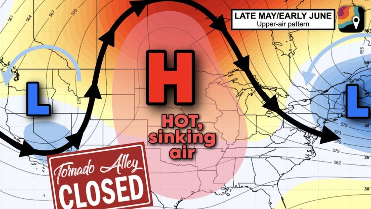
The omega block is a large-scale atmospheric configuration where a dominant high pressure dome sits over the central U.S., flanked on both sides by counterclockwise-rotating low pressure systems. The three systems interlock like gears and become stuck in place.
How the omega block eliminates tornado chances:
- Hot, dry, sinking air beneath the high dome suppresses all storm development
- Clockwise-spinning high prevents moisture from reaching storm-hungry air masses
- Jet stream shunted north into Canada, removing the wind energy storms need to spin
- Upper-air disturbances blocked from entering the Plains by the dominant high
- No momentum aloft means even if storms try to develop, rotation cannot establish
- Pattern expected to remain locked for 7 to 10 days, preventing any meaningful storm setups
The Late May and Early June Upper Air Pattern Explained
The upper air pattern map labeled Late May and Early June shows the full picture of the current atmospheric configuration.
Upper air pattern breakdown:
| Feature | Position | Effect |
|---|---|---|
| High pressure dome (H) | Central United States | Hot sinking air, storm suppression |
| Low pressure (L) | Western U.S. / Pacific | Active weather on west side only |
| Low pressure (L) | Eastern U.S. / Atlantic | Active weather on east side only |
| Jet stream | Deflected into Canada | No wind energy available over Plains |
| Central Plains | Sandwiched between systems | Completely cut off from storm energy |
The two lows flanking the central high are locked in position, with curved flow arrows on the map showing how atmospheric energy is being redirected around the Plains rather than through it.
A Very Quiet Week Ahead for Most of the Nation
Beyond tornado activity, the broader severe weather picture is equally quiet through the close of May.
National severe weather outlook through early June:
- Most of the nation will remain uncharacteristically quiet through the week
- No widespread severe weather setups are expected across the Plains
- Only a random mesoscale accident could produce a highly localized storm threat
- That scenario remains unlikely but cannot be completely ruled out at zero probability
- The quiet spell is expected to hold until at least June 6 before the pattern begins to shift
When Could Tornado Alley Reopen
The omega block pattern is forecast to remain stuck in place for 7 to 10 days, meaning meaningful change to the severe weather pattern is not expected before approximately June 6. After that date, the block may begin to break down and allow storm energy to return to the Plains.
Pattern change timeline:
| Period | Expected Conditions |
|---|---|
| Now through June 5 | Omega block locked, Tornado Alley closed |
| Around June 6 | Possible pattern shift begins |
| Second week of June | Potential for storm chances to return |
| Timing confidence | Moderate, subject to change |
What This Means for Plains Residents
For communities across Oklahoma, Texas, Kansas, Nebraska, and the broader Tornado Alley region, the current pattern delivers a rare and welcome break during what is normally the most dangerous stretch of the year.
- No tornado watches or warnings expected through early June
- Outdoor and agricultural activities can proceed with significantly reduced severe weather concern
- Heat will be the primary weather story across the Plains under the sinking air dome
- Monitor forecasts around June 6 as the pattern may begin to shift after that date
- The quiet spell is real but temporary and storm season will resume when the block breaks
Stay with CabarrusWeekly.com for continuing updates on the Plains severe weather pattern and the outlook for when Tornado Alley reopens in June.