Cooler Than Normal Temperatures to Close Out May and Start June Across Minnesota, Wisconsin, Ohio, the Carolinas, and the Eastern United States as Northerly Flow Takes Over
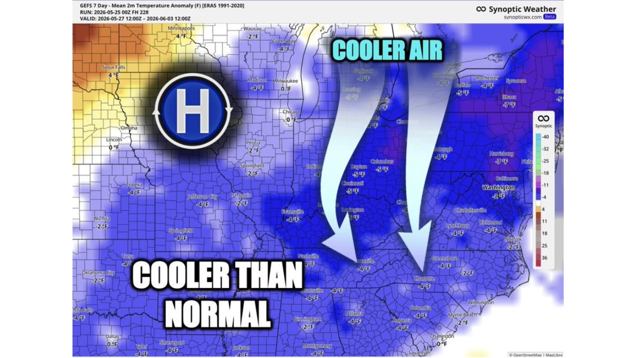
UNITED STATES — Cooler than normal temperatures will dominate a large portion of the eastern United States from May 27 through June 3, 2026, as a northerly flow pattern drives temperatures a few degrees below normal across the Midwest, Great Lakes, Ohio Valley, Mid-Atlantic, and Carolinas heading into the start of meteorological summer. The GEFS 7-day mean temperature anomaly run initialized at 00z May 25, 2026 confirms the cool pattern with no significant summer heat in the forecast for this period.
Temperature Anomalies by City and Region
The forecast map shows a broad swath of below normal temperature anomalies stretching from the Upper Midwest through the Southeast coast.
Temperature anomaly breakdown by location:
| City / Area | Temperature Anomaly |
|---|---|
| Minneapolis | 4 F below normal |
| Green Bay | 4 F below normal |
| Milwaukee | 0 F near normal |
| Chicago | 0 F near normal |
| Saginaw / Lansing | 4 F below normal |
| Buffalo | 4 F below normal |
| Toronto area | 5 F below normal |
| Rochester / Syracuse | 5 to 7 F below normal |
| Columbus / Dayton | 5 F below normal |
| Cincinnati / Lexington | 4 to 5 F below normal |
| Indianapolis | Near normal |
| Pittsburgh | 4 F below normal |
| Harrisburg | 7 F below normal |
| Washington D.C. | 2 F below normal |
| Richmond / Lynchburg | 4 F below normal |
| Charlotte | 4 F below normal |
| Greensboro | 4 F below normal |
| Atlanta | 2 F below normal |
| Birmingham | 2 F below normal |
| Huntsville | 4 F below normal |
| Columbia / Augusta | 4 F below normal |
| Charleston | 0 F near normal |
| Myrtle Beach | 2 F below normal |
| Nashville | 1 F below normal |
| Evansville | 4 F below normal |
| Sioux Falls | 4 F below normal |
| Omaha / Lincoln | 0 F near normal |
| Topeka | 4 F below normal |
| Wichita | 2 F below normal |
| Tulsa | 4 F below normal |
| Oklahoma City | 2 F below normal |
| Dallas | 0 F near normal |
| Shreveport / Tyler | 4 F below normal |
| Montgomery | 4 F below normal |
What Is Driving the Cool Pattern
A high pressure system positioned over the central United States is the primary driver of the below normal temperatures heading into early June.
How the pattern produces cooler conditions:
- Northerly flow pulls cooler Canadian air southward across the Midwest and East
- High pressure clockwise circulation draws air from the north rather than from the warm Gulf
- No significant heat ridge is positioned to push warmth northward during this period
- Cool air mass is deep enough to keep temperatures below normal across a wide geographic footprint
- No big time summer heat is expected to challenge this pattern through at least June 3
Where the Warmest Anomalies Are Located
While the eastern two thirds of the country trends cooler than normal, the western edge of the map tells a different story. Portions of the western Plains and upper Midwest show above normal temperature anomalies on the warm side of the high pressure system.
Above normal temperature areas:
| Area | Anomaly |
|---|---|
| Sioux Falls area western edge | 4 F above normal |
| Far western Kansas / Nebraska | Slightly above normal |
| Western Oklahoma fringe | Near to slightly above normal |
This warm pocket represents the western flank of the high, where southerly flow ahead of the system is drawing warmer air into a narrow corridor.
No Summer Heat Threat Through Early June
For residents across the Midwest, Ohio Valley, Mid-Atlantic, Carolinas, and Southeast, the forecast through June 3 does not include any significant heat events. The pattern entering meteorological summer on June 1 will feel more like a continuation of late spring rather than a summer warmup.
What to expect through June 3:
- Temperatures averaging 2 to 7 degrees below normal across most of the East
- No heat waves or dangerous heat anticipated during this period
- Comfortable conditions for late May and early June outdoor activities where rain is not a factor
- Pattern could shift after June 3 as the high pressure system evolves
- Monitor forecasts as the start of meteorological summer approaches for any changes beyond the current outlook window
Stay with CabarrusWeekly.com for continuing updates on the temperature outlook and pattern evolution heading into June across the United States.