Baltimore, Maryland Faces Pattern Flip Wednesday With Major Storms Possible After 1 to 4 Inches of Rain Already Fallen Since Last Wednesday as Front Stalls South of the City
BALTIMORE, MARYLAND — The Baltimore metro has recorded 1 to 4 inches of rain since last Wednesday as a stalled frontal boundary continues to sit south of the city, keeping the region locked in a persistently wet pattern. A critical pattern flip is possible Wednesday May 27, with significant storms capable of developing before the region finally turns drier and less humid by the end of the week.
The Frontal Boundary Holding Everything in Place
A surface analysis map shows the frontal system that has driven the rainy pattern still positioned south of Baltimore this morning. The placement of this front is the single most important factor controlling the week ahead.
Current frontal boundary status:
| Feature | Current Position | Significance |
|---|---|---|
| Cold front | South of Baltimore | Keeping moist, unsettled air locked over the metro |
| Warm sector | Draped across Virginia and southward | Temperatures in the mid 60s to low 70s south of front |
| Surface high pressure | North of the region | Blocking the front from pushing north quickly |
| Dew points south of front | 65 to 68 degrees | Deep moisture fueling continued rain chances |
The front needs to push north of Baltimore for the pattern to change. Until that happens, the wet and humid conditions persist.
What Has Already Fallen Since Last Wednesday
The Baltimore metro has absorbed a significant amount of rainfall over the past several days with the front anchored nearby.
Rainfall summary since last Wednesday:
| Area | Total Rainfall |
|---|---|
| Baltimore Metro widespread | 1 to 4 inches |
| Heaviest localized totals | Up to 4 inches in some spots |
| Lightest totals in the metro | Around 1 inch |
| Pattern duration | Since Wednesday of last week |
This prolonged wet stretch has saturated soils across the region, meaning any additional heavy rainfall this week will have limited absorption capacity and an elevated runoff and flooding risk.
Wednesday Is the Key Day to Watch
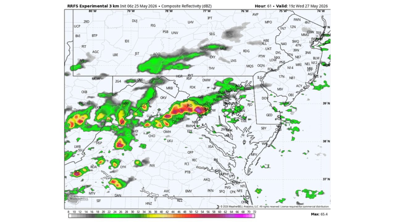
The RRFS Experimental model initialized at 06z May 25, 2026, valid at 19z Wednesday May 27, 2026, shows a corridor of significant radar returns pushing through the Baltimore and Washington D.C. metro area Wednesday afternoon and evening, with red and purple reflectivity values indicated directly over the region suggesting intense rainfall rates with the strongest cells.
Wednesday storm potential breakdown:
| Factor | Status |
|---|---|
| Pattern flip trigger | Front moving north of Baltimore |
| Storm timing | Wednesday afternoon and evening |
| Storm intensity potential | Significant, described as Big Boomers |
| Radar model max value | 65.4 dBZ indicating intense cells |
| Primary threats | Heavy rain, lightning, gusty winds |
| Flood risk | Elevated given already saturated soils |
If the front successfully moves north of Baltimore in the next day or two, the atmosphere will be primed for a significant convective event Wednesday before the pattern finally dries out.
The Risk That Changes Everything
The entire Wednesday scenario hinges on one critical variable. If the frontal boundary fails to push north of Baltimore, the pattern flip does not occur on schedule and the region remains in the same persistent wet, cloudy, and unsettled setup without the dramatic storm event.
Two possible scenarios heading into Wednesday:
- Front moves north of Baltimore — Pattern flips, significant storms develop Wednesday, dry and less humid conditions arrive by end of week
- Front stalls or retreats south — Wet and humid pattern continues, Wednesday storm threat diminishes, drier conditions delayed
Forecasters are watching the frontal movement closely through Monday and Tuesday as the determining factor for the Wednesday outcome.
Drier and Less Humid Conditions Expected by Week’s End
Regardless of exactly how Wednesday plays out, the broader pattern trend points toward drier and less humid conditions arriving by the end of the week across the Baltimore metro and surrounding region. The front pushing through, whether gradually or with a bang Wednesday, will eventually flush out the oppressive moisture that has been fueling the rainy stretch since last Wednesday.
End of week outlook:
- Thursday and Friday trending drier as front clears the region
- Humidity levels dropping noticeably after the frontal passage
- Sunshine returning to the Baltimore metro by the latter half of the week
- Temperatures moderating as cooler and drier air filters in behind the front
Stay with CabarrusWeekly.com for continuing updates on the Baltimore weather pattern and the critical Wednesday storm timing through the week ahead.