Eastern United States Records Widespread 4 to 5 Inches of Rain Over 7 Days as Saturated Soils Raise Flooding Concerns Across the Southeast While Midwest Prepares for Drier Pattern
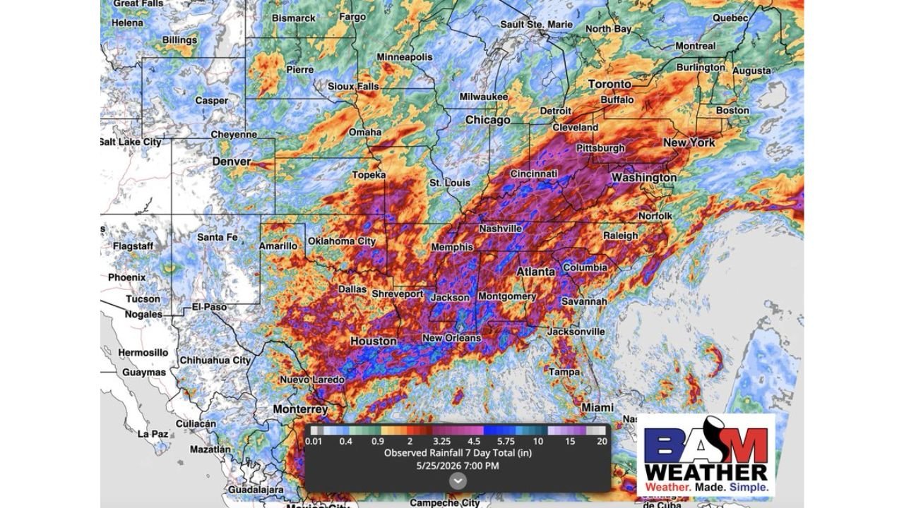
EASTERN UNITED STATES — The past 7 days across the Eastern United States have delivered widespread rainfall totals of 4 to 5 inches across a massive corridor stretching from the Gulf Coast through the Mid-Atlantic and into the Great Lakes, according to observed 7-day rainfall data valid at 7:00 PM May 25, 2026. The prolonged wet stretch has produced very moist soil conditions across the same areas, creating a split outlook — welcome drying for the Midwest heading into field work season, but escalating flooding concerns for the Southeast where the active rain pattern continues.
7-Day Observed Rainfall Totals Across the Eastern U.S.
The BAM Weather observed rainfall map shows the extraordinary scope of the past week’s precipitation across the country.
7-day rainfall totals by region:
| Region | Observed Total | Color Zone |
|---|---|---|
| Louisiana / Mississippi / Alabama core | 10 to 20 inches | Purple / Pink |
| Tennessee / Kentucky / Arkansas | 5.75 to 10 inches | Dark red / Purple |
| Missouri / Illinois / Indiana | 4.5 to 5.75 inches | Red / Orange |
| Ohio Valley / Cincinnati / Pittsburgh | 3.25 to 5.75 inches | Orange / Red |
| Washington D.C. / Mid-Atlantic | 3.25 to 5.75 inches | Orange / Red |
| Carolinas / Georgia / Atlanta | 3.25 to 5.75 inches | Orange / Red |
| Great Lakes / Chicago / Detroit | 2 to 4.5 inches | Yellow / Orange |
| New York / Boston corridor | 2 to 3.25 inches | Yellow |
| Oklahoma / Texas / Dallas | 2 to 5.75 inches | Yellow to Red |
| Northern Plains / Dakotas | 0.4 to 2 inches | Light blue / Green |
| Mountain West | 0.01 to 0.9 inches | Minimal |
The deepest purple and pink zones concentrated across Louisiana, Mississippi, and Alabama represent the most extreme 7-day accumulations on the map, with isolated totals reaching into the 15 to 20 inch range in the hardest hit corridors.
What the Soil Moisture Map Reveals
The Agriculture Soil Moisture Percentile map valid at 8:00 PM May 24, 2026 shows the direct impact of the past week’s rainfall on ground conditions across the country.
Soil moisture status by region:
| Region | Soil Moisture Percentile | Condition |
|---|---|---|
| Northern Plains / Dakotas / Nebraska | 2 to 10 percentile | Extremely dry, drought conditions |
| Kansas / Oklahoma / Central Plains | 2 to 20 percentile | Very dry to dry |
| Colorado / Wyoming | 2 to 10 percentile | Extremely dry |
| Missouri / Illinois / Indiana | 70 to 95 percentile | Very moist to wet |
| Ohio Valley | 70 to 90 percentile | Very moist |
| Mid-Atlantic / Washington D.C. | 70 to 90 percentile | Very moist |
| Southeast / Georgia / Carolinas | 70 to 90 percentile | Very moist to saturated |
| Louisiana / Mississippi / Alabama | 90 to 98 percentile | Saturated, at or near capacity |
| Great Lakes / Chicago corridor | 70 to 90 percentile | Very moist |
| Minnesota / Wisconsin | 80 to 95 percentile | Very moist |
The stark contrast between the blood red drought conditions across the Northern Plains and the deep blue saturated soils across the Southeast and Mid-Atlantic tells the story of two completely different weather realities playing out simultaneously across the country.
The Midwest Split — Drier Pattern Is Good News for Field Work
For the Midwest states including Illinois, Indiana, Iowa, Missouri, and surrounding areas, the combination of very moist soils and an incoming drier pattern creates a favorable agricultural window.
Midwest outlook for field work:
- Moist soils from the recent rainfall improve trafficability as they begin to dry
- Drier pattern setting in will allow fields to reach workable conditions quickly
- Planting and field operations that were delayed by wet weather can resume
- No significant rain threats expected to interrupt the drying window in the near term
- Soil moisture at high percentiles means crops are well supplied heading into the drier stretch
The Southeast Problem — Saturated Soils and More Rain Coming
For the Southeast including Louisiana, Mississippi, Alabama, Georgia, and the Carolinas, the picture is the opposite of the Midwest and carries serious concerns.
Southeast flooding risk factors:
- Soils at 90 to 98 percentile saturation across Louisiana, Mississippi, and Alabama
- No absorption capacity remaining in the hardest hit areas
- Active rain pattern continuing with no meaningful dry period in the immediate forecast
- Any additional rainfall runs off immediately into streams, creeks, and drainage systems
- Flash flooding and river flooding risks are elevated and increasing with each additional rain event
- 10 to 20 inch totals already recorded over just 7 days create a foundation for dangerous flooding scenarios going forward
Two Americas in One Weather Map
The combination of the rainfall map and the soil moisture map together illustrates a dramatic national weather divide as of late May 2026.
The national contrast at a glance:
| Region | 7-Day Rain | Soil Moisture | Outlook |
|---|---|---|---|
| Northern Plains | Under 2 inches | Extremely dry, 2 to 10 percentile | Drought expanding |
| Midwest | 4 to 5 inches | Very moist, 70 to 90 percentile | Drier pattern welcome |
| Southeast | 5 to 20 inches | Saturated, 90 to 98 percentile | Flooding threat rising |
| Mid-Atlantic | 3 to 5 inches | Very moist, 70 to 90 percentile | Active pattern continues |
Stay with CabarrusWeekly.com for continuing updates on rainfall totals, soil moisture conditions, and the flooding outlook across the Eastern United States.