Utah Faces Showers Along the Wasatch Front Tuesday Morning and Mountain Thunderstorms Tuesday Afternoon as Weak Storm System Tracks Across the State
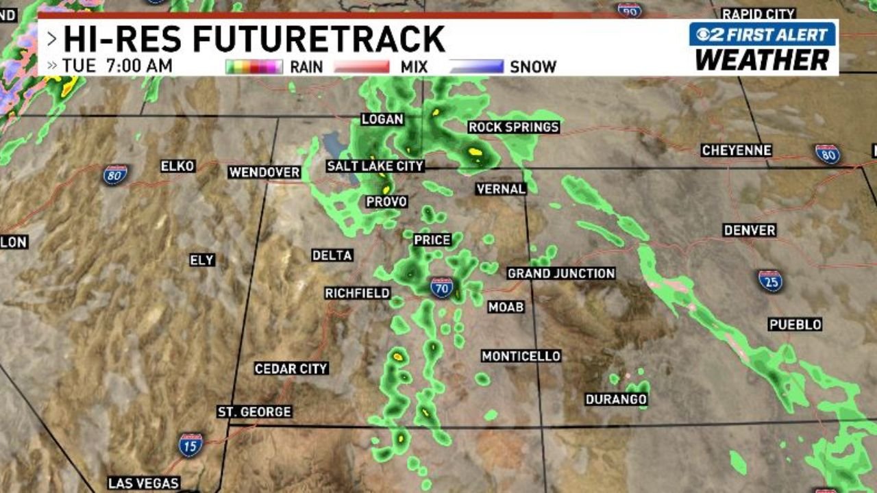
UTAH — A weak storm system moving across Utah over the next 24 hours will bring showers to southern and central Utah tonight, lift moisture into northern Utah and the Wasatch Front Tuesday morning, and develop pop-up thunderstorms over the mountains Tuesday afternoon, particularly between I-80 and I-70. The First Alert Hi-Res FutureTrack model shows the progression clearly from the 7:00 AM Tuesday snapshot through the 4:00 PM Tuesday afternoon storm development.
Storm System Timeline Tuesday
Hour by hour progression across Utah:
| Time | Area Affected | Conditions |
|---|---|---|
| Tonight | Southern and Central Utah | A few showers developing |
| Tuesday 7:00 AM | Northern Utah / Wasatch Front | Light rain during the morning commute |
| Tuesday morning | Salt Lake City, Logan, Provo | Light rain, commute impacts possible |
| Tuesday afternoon | Mountains near and south of I-80 | Pop-up thunderstorms developing |
| Tuesday afternoon | Mountains north of I-70 | Additional thunderstorm development |
| Tuesday 4:00 PM | Broader mountain zones | Scattered storms, orange returns near Price and Provo |
What the FutureTrack Model Shows at 7:00 AM Tuesday
The Hi-Res FutureTrack valid at 7:00 AM Tuesday shows light green radar returns spreading across northern Utah with activity concentrated along and near the Wasatch Front corridor.
7:00 AM conditions by location:
| Location | Forecast Condition |
|---|---|
| Salt Lake City | Light rain moving in |
| Logan | Light rain coverage |
| Provo | Showers approaching |
| Price / Central Utah | Showers continuing from overnight |
| Rock Springs Wyoming | Green returns on northern edge |
| Grand Junction area | Light activity on eastern fringe |
| Cedar City / St. George | Diminishing overnight showers |
The morning commute across the Wasatch Front will see light rain as the moisture lifts northward from central Utah during the overnight hours.
What the FutureTrack Model Shows at 4:00 PM Tuesday
By 4:00 PM Tuesday, the storm system has evolved significantly with afternoon heating triggering thunderstorm development across the mountain zones.
4:00 PM conditions by location:
| Location | Forecast Condition |
|---|---|
| Provo / Price corridor | Orange and yellow returns, stronger storms |
| Salt Lake City area | Green returns continuing |
| Rock Springs area | Orange returns developing |
| Vernal area | Scattered green activity |
| Grand Junction / Moab fringe | Scattered light activity |
| Durango area | Active green and orange cells developing |
| Cedar City southward | Clearing from the south |
The orange returns near Price and the I-70 corridor on the afternoon model indicate stronger storm development in the mountain terrain between the two major interstates.
The Mountain Zone Between I-80 and I-70 Is the Focus
Forecasters are specifically highlighting the mountain terrain between I-80 to the north and I-70 to the south as the primary area for afternoon thunderstorm development on Tuesday.
Mountain storm threat details:
- Pop-up thunderstorms will develop as afternoon heating interacts with the residual moisture
- Mountains near and south of I-80 are the most likely initiation zone
- North of I-70 provides a second corridor of development
- Lightning will accompany any developing storms in the mountain terrain
- Hikers, campers, and outdoor recreationists in the mountain zones should plan to be off exposed terrain before early afternoon
Wasatch Front Commute Impact Tuesday Morning
The light rain moving into Salt Lake City, Logan, and Provo during the Tuesday morning commute hours will create slick road conditions across the northern Utah urban corridor.
Commute considerations:
- Allow extra travel time along I-15 and I-80 through the Salt Lake Valley
- Light rain reduces visibility and increases stopping distances
- Overpasses and bridges may be slippery in the early morning hours
- Rain should be light and not a major disruption but worth accounting for in travel planning
Stay with CabarrusWeekly.com for continuing updates on Utah’s Tuesday weather timeline and mountain storm development through the afternoon.