Baltimore Metro Faces Heavy Rain and Gusty Winds Between 10 and 11 AM Wednesday as Slow Driving Conditions Spread Across the City and Surrounding Areas
BALTIMORE, MARYLAND — Periods of heavy rain and gusty winds are moving through the Baltimore Metro on the morning of Wednesday May 27, 2026, with the most intense activity expected to impact Baltimore City and surrounding communities between 10 AM and 11 AM. Drivers across the region should expect slow and hazardous conditions during the passage of the storm.
What Live Radar Shows at 9:58 AM Wednesday
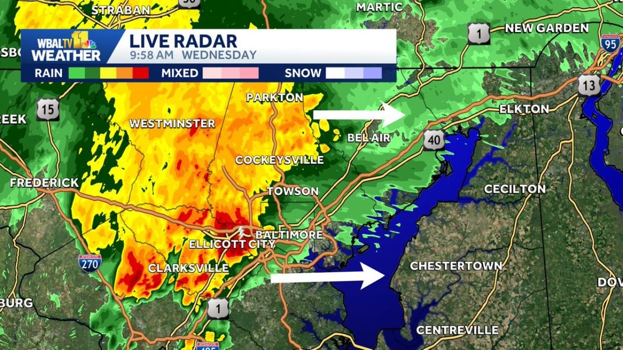
Live radar captured at 9:58 AM Wednesday shows a broad and intense area of heavy rainfall pushing eastward across the Baltimore metro, with red and deep orange returns concentrated directly over the city core and western suburbs.
Current conditions by location:
| Area | Radar Status |
|---|---|
| Baltimore City | Heavy red returns, most intense rainfall |
| Ellicott City | Deep red, heaviest cells |
| Clarksville | Intense rainfall ongoing |
| Westminster | Heavy orange and red returns |
| Cockeysville / Towson | Active heavy rain moving through |
| Bel Air | Storm line approaching from the west |
| Frederick | Heavy activity on the western edge |
The storm system is tracking eastward, with white arrows on the radar indicating the direction of movement pushing the heaviest rain toward Bel Air, Elkton, and the upper Chesapeake Bay corridor through the late morning hours.
Driving Conditions Deteriorating Across the Metro
The combination of heavy rainfall rates and gusty winds arriving simultaneously during the mid-morning hours is creating dangerous driving conditions across major corridors.
Roads most affected:
- I-695, I-95, I-270, and Route 40 are all seeing reduced visibility and standing water
- Ellicott City and Clarksville corridors historically prone to rapid water rises during heavy rain events
- Allow significantly extra travel time if commuting through the Baltimore metro between 10 and 11 AM
- Reduce speed and increase following distance across all affected corridors
Storm Clears to the East by Late Morning
The storm line is moving steadily eastward and is expected to push through the immediate Baltimore metro within the 10 AM to 11 AM window. Communities east of the city including Bel Air, Elkton, and the Eastern Shore will see the heaviest activity arrive shortly after the city clears.
Stay with CabarrusWeekly.com for continuing radar updates and storm timing across the Baltimore metro this Wednesday morning.