Florida Enters June With Above Normal Precipitation Outlook as Nearly Three Quarters of the State Sits Under Extreme to Exceptional Drought
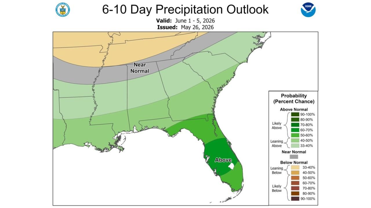
FLORIDA — A wet start to June is favored for Florida according to the 6 to 10 Day Precipitation Outlook issued May 26, 2026, valid for June 1 through June 5, placing the state in the above normal precipitation category at a critical moment. The U.S. Drought Monitor valid May 19, 2026 shows nearly three quarters of Florida designated at extreme D3 to exceptional D4 drought, the two most severe drought categories on the scale.
How Bad the Drought Is Right Now
The drought map tells a stark story about Florida’s moisture deficit heading into June.
Florida drought coverage by category:
| Drought Category | Intensity | Coverage |
|---|---|---|
| D4 Exceptional | Most severe | Central Florida, South Florida, Southwest Florida |
| D3 Extreme | Severe | North Central Florida, portions of the Peninsula |
| D2 Severe | Serious | Parts of North Florida and Panhandle fringe |
| D1 Moderate | Moderate | Northwest Florida Panhandle |
| D0 Abnormally Dry | Early stage | Scattered fringe areas |
| No Drought | None | Minimal coverage statewide |
Nearly three quarters of the entire state sits at D3 or D4, meaning the vast majority of Florida is experiencing either extreme or exceptional drought conditions heading into the June rainfall window.
What the 6 to 10 Day Outlook Shows
The 6 to 10 Day Precipitation Outlook issued May 26, 2026 and valid for June 1 through June 5 places Florida clearly in the above normal precipitation zone.
Precipitation outlook by region:
| Region | Outlook Category |
|---|---|
| Florida statewide | Above normal precipitation favored |
| South Florida | Above normal, strongest signal |
| Central Florida | Above normal |
| North Florida | Above normal |
| Georgia and Carolinas | Near normal to leaning above |
| Mid-Atlantic | Near normal |
| Midwest and Northeast | Near normal to below normal |
Florida is the most favored above normal precipitation zone on the entire outlook map, with the deepest green shading centered over the southern half of the peninsula.
Why This Matters for the Worst Drought in 25 Years
Florida is currently experiencing its worst drought in over 25 years. The combination of the D3 and D4 drought footprint covering three quarters of the state and the incoming above normal precipitation signal creates the most significant drought relief opportunity the state has seen in many months.
What above normal June rainfall means for drought recovery:
- D4 Exceptional drought requires sustained and significant above normal rainfall over weeks to months to fully recover
- A wet June start can meaningfully reduce drought intensity across D3 and D4 zones
- Daily afternoon downpours through June 8 will help recharge soil moisture and surface water bodies
- Full drought elimination will require above normal rainfall to persist well beyond this single outlook period
- Localized flooding remains possible even in drought areas as intense downpours overwhelm dry and hardened soils
The Road Ahead for Florida
The above normal precipitation outlook for early June represents a genuine turning point for Florida’s drought situation, but not an immediate solution. Forecasters and water managers are cautiously optimistic that the incoming wet pattern can make a meaningful dent in the exceptional and extreme drought covering most of the state, while acknowledging that months of above normal rainfall will ultimately be needed to fully close the moisture deficit.
Stay with CabarrusWeekly.com for continuing updates on Florida’s drought relief forecast and the June precipitation outlook across the state.