Washington D.C., Northern Virginia, and Southern Maryland Face Slight Risk Severe Weather Wednesday With Heavy Downpours and Stronger Winds Expected During the Early Afternoon
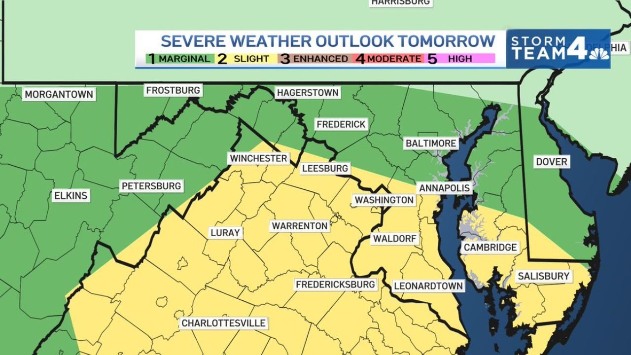
WASHINGTON D.C. AND THE MID-ATLANTIC — Wednesday is shaping up to be a Weather Alert Day across the Washington D.C. metro, Northern Virginia, and Southern Maryland, with the severe weather outlook placing the region under a Slight Risk level 2 of 5 for the early afternoon hours. Heavy downpours are the biggest concern alongside stronger wind gusts as storms move through the region.
Risk Zone Breakdown for Wednesday
Severe weather outlook by area:
| Risk Level | Zone | Cities Included |
|---|---|---|
| Slight Risk (2/5) | Northern Virginia / D.C. fringe | Washington D.C., Leesburg, Warrenton, Luray, Winchester fringe |
| Slight Risk (2/5) | Southern Maryland | Waldorf, Leonardtown, Fredericksburg area |
| Marginal Risk (1/5) | Central Maryland | Baltimore, Annapolis, Frederick, Hagerstown |
| Marginal Risk (1/5) | Western Maryland / West Virginia | Frostburg, Morgantown, Elkins, Petersburg |
| General Thunderstorms | Eastern Shore / Delaware | Cambridge, Salisbury, Dover |
The Slight Risk zone covers a corridor running from Northern Virginia through the D.C. suburbs and into Southern Maryland, with the marginal risk zone wrapping around Baltimore and the broader central Maryland region.
Primary Hazards Wednesday Afternoon
What to expect with Wednesday storms:
- Heavy downpours are the headline hazard with intense rainfall rates possible during storm passage
- Stronger wind gusts with the most organized cells moving through
- Flooding concerns elevated given soils already saturated from over a week of repeated rainfall across the region
- Storm timing focused on the early afternoon hours with conditions improving later in the day
- Tornado threat is low but cannot be completely ruled out within the Slight Risk zone
The Saturated Soil Factor Makes Heavy Rain More Dangerous
The D.C. metro and surrounding region has absorbed 1 to 4 inches of rainfall over the past 8 to 9 days from a persistent wet pattern. Wednesday’s heavy downpours will arrive on ground that has little remaining capacity to absorb additional moisture.
Flooding risk factors:
- Rapid runoff likely even from moderate rainfall rates
- Low lying roads and underpasses in the D.C. metro are especially vulnerable
- Never drive through flooded roadways regardless of apparent water depth
- Allow extra travel time during the early afternoon storm window
Stay with CabarrusWeekly.com for continuing updates on the Wednesday severe weather outlook across Washington D.C., Northern Virginia, and Maryland.