Texas Faces Sneaky Low-End Tornado Risk as Two Mesoscale Convective Vortices Spin Up Across the State
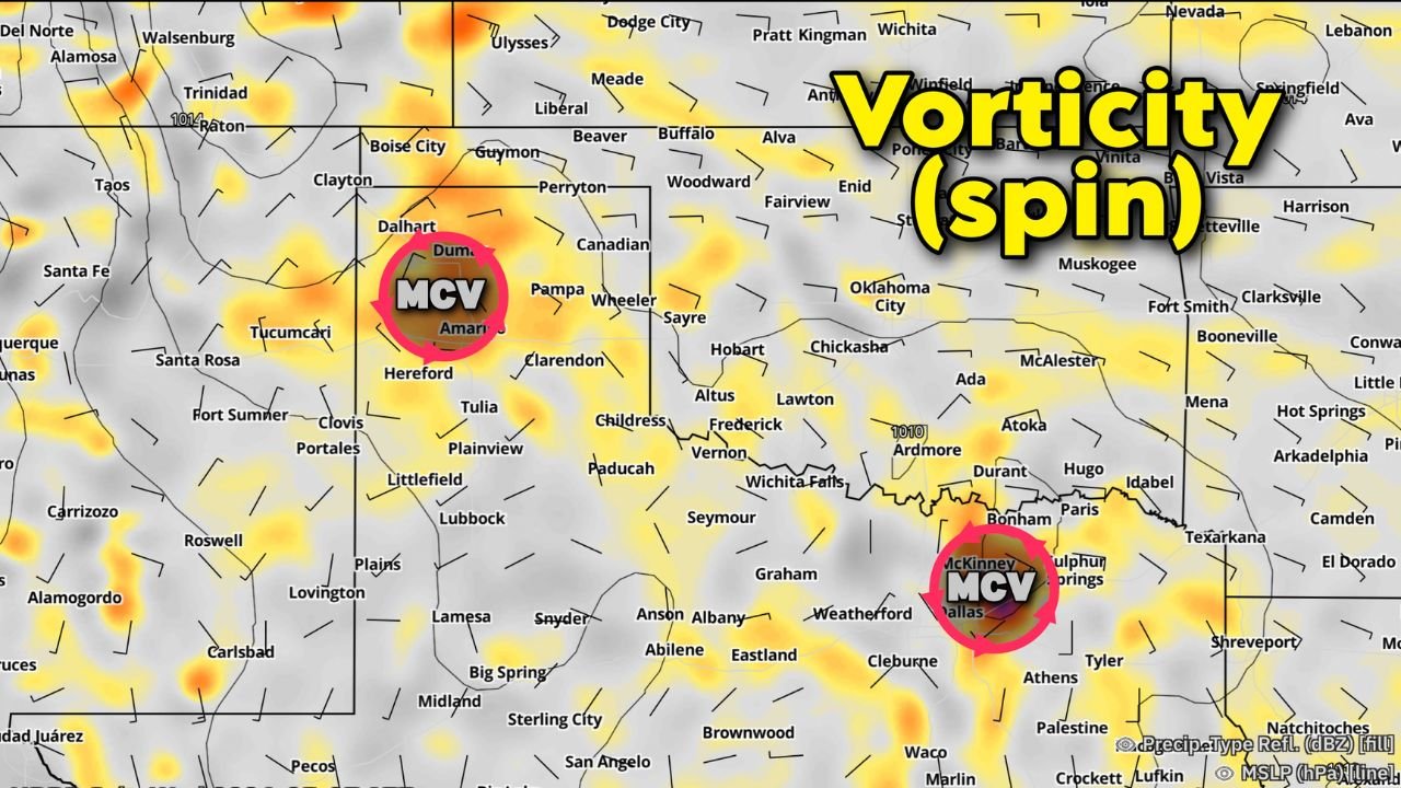
TEXAS — Two small but significant zones of enhanced surface spin have developed across Texas as of midafternoon on Wednesday, May 27, left behind by previous storm activity. These rotating features, known as Mesoscale Convective Vortices (MCVs), are introducing a low-end but real tornado risk across parts of the state later today.
What Is a Mesoscale Convective Vortex
An MCV is a pocket of rotating air that spins up in the wake of organized thunderstorm clusters. While not as dramatic as a supercell tornado setup, MCVs carry extra atmospheric spin that can interact with developing storms and produce isolated tornado activity even in environments that would otherwise not support it. Forecasters describe the threat as sneaky precisely because it can catch residents off guard.
Where the Two MCVs Are Located
The forecast graphics show two distinct MCV signatures currently affecting Texas:
- MCV 1 is located in the Texas Panhandle and South Plains region, centered near the Amarillo and Pampa area, tracking toward the southeast
- MCV 2 is positioned across central to east Texas, centered near the Sulphur Springs and Texarkana corridor, also tracking eastward
Both systems are producing areas of enhanced vorticity across a broad swath of the state, from the panhandle down through north and east Texas.
Isolated Tornado Risk in Play
The upper left panel of the graphic explicitly labels the threat zone with “ISOLATED TORNADO” across a large green highlighted area covering north-central to east Texas, including the regions near Amarillo, Wichita Falls, Fort Worth, Dallas, and Texarkana. This area aligns directly with the MCV tracks shown on the lower panels.
The risk is categorized as isolated and low-end, meaning widespread tornado outbreaks are not expected. However, any tornado that does develop could occur with little warning given the MCV-driven nature of the threat.
What Texas Residents Should Do Now
Residents across north-central, east, and south plains Texas should remain weather-aware through the remainder of Wednesday afternoon and evening. Key points:
- Have a weather alert method ready and active
- Know your shelter location in advance
- Monitor local conditions as storms develop near the MCV zones
- Do not wait for a tornado warning to take shelter if storms approach
Stay with CabarrusWeekly.com for continuing updates as this MCV-driven tornado threat evolves through Wednesday evening.