Florida, Louisiana and Georgia See Early Tropical Development Signal in Gulf and Southeast as 3 of 64 Ensemble Members Flag Activity for Late Next Week
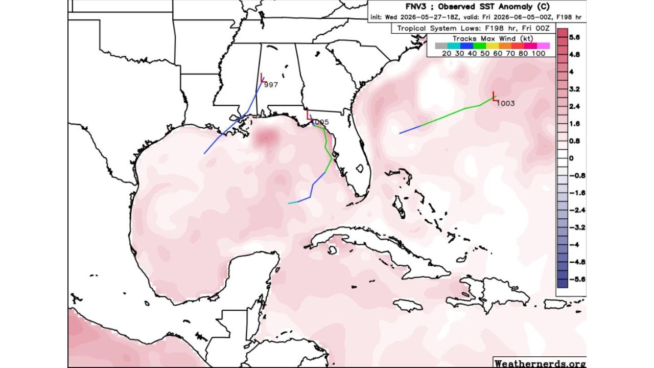
GULF OF MEXICO — A subtle but notable tropical development signal has appeared in long-range ensemble guidance, with 3 out of 64 ensemble members now showing possible tropical system development in the Gulf of Mexico or Southeast region by the middle to end of next week. The map is valid through Friday, June 5, 2026, and shows three distinct low-pressure track scenarios across the region.
What the Ensemble Map Is Showing
The graphic displays three separate tropical system track members, each representing a different possible development scenario:
- Track 1 (Blue) shows a low pressure system at 997 mb developing over the central Gulf Coast region near Louisiana and Mississippi, tracking northwest into the interior
- Track 2 (Green/Blue) shows a system at 995 mb initiating near the Florida Gulf Coast and tracking southward toward the Florida Straits
- Track 3 (Green) shows a system at 1003 mb developing well out in the western Atlantic east of Florida, tracking northeast away from land
Only 3 of 64 Members: Keep This in Perspective
This is an early and weak signal. With only 3 out of 64 ensemble members flagging tropical development, forecasters describe this as a subtle signal only. The overwhelming majority of ensemble members show no tropical development and instead keep the region’s headline story focused on daily rains and storms through next week.
Confidence in any specific track, intensity, or landfall scenario is very low at this stage.
Sea Surface Temperatures Add Context
The background of the map shows observed sea surface temperature anomalies across the Gulf and Atlantic. The entire Gulf of Mexico and western Atlantic is shaded in pink, indicating above-normal sea surface temperatures across the region. Warm sea surface temperatures are one ingredient that supports tropical development when atmospheric conditions align.
What the Gulf Coast and Southeast Should Watch
States along the Gulf Coast and Southeast, including Louisiana, Mississippi, Alabama, Florida and Georgia, fall within the general zone where the active ensemble members are pointing. However, with such low ensemble agreement, no specific threat can be identified at this time. The primary weather story next week remains daily rain and storm chances driven by the existing atmospheric pattern.
Forecasters will continue to monitor whether additional ensemble members begin showing interest in tropical development as the pattern evolves through the weekend.
Stay with CabarrusWeekly.com for continuing updates as the tropics are monitored through late May and into early June.