Florida Rainfall Forecast Drops Sharply From 6 to 7 Inches Down to 1 to 2 Inches as Latest Model Run Shows Major Trend Reversal Through June 8
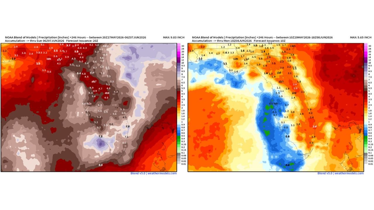
FLORIDA — A dramatic shift in the rainfall forecast for Florida has emerged between two model runs just days apart, with projected totals across the peninsula dropping significantly from what was showing as a multi-inch super soaker down to just 1 to 2 inches for most of the state through Monday, June 8, 2026. The reversal is a striking example of how rapidly atmospheric forecasts can change at extended ranges.
What the Earlier Forecast Was Showing
The first model run, valid through Sunday, June 7, 2026, was painting a heavy rainfall bullseye directly over Florida. Totals across that run included:
| Region | Earlier Forecast Total |
|---|---|
| Central Florida | 4.5 to 5.4 inches |
| Tampa Bay corridor | 5.7 to 6.5 inches |
| South Central Florida | 5.4 to 7.8 inches |
| Southeast Florida coast | 6.5 to 7.5 inches |
| Florida tip | 5.3 inches |
The maximum value on that run reached 9.83 inches, with widespread totals suggesting a prolonged and significant soaking across the drought-stricken peninsula.
What the Latest Forecast Is Showing
The updated model run, valid through Monday, June 8, 2026, tells a dramatically different story. The bullseye over Florida has essentially evaporated, replaced by a broad blue zone indicating well-below-normal totals across much of the peninsula:
| Region | Latest Forecast Total |
|---|---|
| North Florida | 1.4 to 2.3 inches |
| North Central Florida | 1.6 to 2.2 inches |
| Central Florida | 0.9 to 1.8 inches |
| Tampa Bay area | 0.5 to 1.2 inches |
| South Florida peninsula | 0.6 to 1.9 inches |
| Southeast Florida coast | 1.9 to 2.8 inches |
The maximum value on the latest run has dropped to just 5.65 inches, and the deep blue shading across central and south Florida indicates totals of well under 1 inch in some locations.
What Changed and What It Means for Drought Relief
The shift reflects changing atmospheric dynamics at extended forecast ranges. What appeared to be a locked-in wet pattern just days ago has trended significantly drier as the model ingests newer data. For a state where 71% of the land area remains in Extreme to Exceptional drought, this forecast revision is a significant setback for drought relief hopes heading into early June.
The key takeaway from forecasters is that extended range rainfall forecasts are inherently uncertain and can shift dramatically in either direction as the event window approaches. The current trend is drier, but that trend can reverse again before June 8 arrives.
The Bottom Line for Florida Residents
Drought-affected communities across Florida should not count on the previously projected heavy rainfall totals materializing. The current forecast suggests modest 1 to 2 inch totals for most of the peninsula through early June, which would provide limited drought relief at best. Continued monitoring of forecast trends over the coming days is essential before drawing conclusions about what the rainy season will ultimately deliver in its opening stretch.
Stay with CabarrusWeekly.com for continuing updates as Florida’s rainfall forecast is tracked through early June.