Illinois, Indiana, Missouri and Kentucky April 27 Moderate Risk Event Produces 25 Tornadoes but Underperforms as Warm Sector Supercells Fail to Sustain
UNITED STATES — A post-event analysis is now underway on the April 27, 2026 Moderate Risk severe weather event that swept across the central United States, and the results tell a story of a system that significantly underperformed its tornado potential. Despite forecasts calling for numerous supercells with intense, long-track tornadoes, the event produced approximately 22 to 25 tornadoes from the afternoon of April 27 into the morning of April 28, with all tornadoes weak and most short-lived. A total of 596 storm reports were recorded across the event.
What the Verification Map Shows
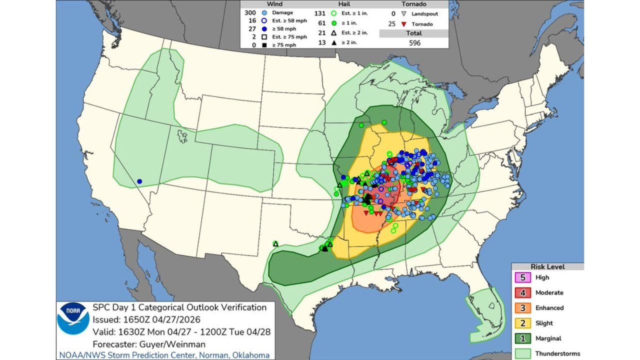
The SPC Day 1 Categorical Outlook Verification map, issued at 1650Z on April 27, 2026 and valid through 1200Z on April 28, shows the full storm report footprint across the Moderate Risk zone. Total reports by category:
| Hazard Type | Report Count |
|---|---|
| Wind Damage Reports | 300 |
| Estimated 58+ mph winds | 16 |
| Confirmed 58+ mph winds | 27 |
| Estimated 75+ mph winds | 2 |
| Confirmed 75+ mph winds | 0 |
| Hail 1 inch or larger (estimated) | 61 |
| Hail 1 inch or larger (confirmed) | 61 |
| Hail 2 inches or larger (estimated) | 21 |
| Hail 2 inches or larger (confirmed) | 13 |
| Landspouts | 0 |
| Tornadoes | 25 |
| Total Reports | 596 |
Why the Event Underperformed on Tornadoes
The core reason the event fell short of its forecast tornado potential comes down to one critical failure: warm sector supercells failed to sustain. Forecasters had specifically anticipated numerous long-track, intense tornadoes in the open warm sector, which historically produces the most dangerous and organized tornado-producing supercells. Instead, storms that moved into the warm sector lost their structure and could not maintain the rotation needed for long-track tornado production.
The approximately 22 to 25 tornadoes that did occur were confined to the weaker end of the spectrum, with none achieving the long-track, violent characteristics that the Moderate Risk outlook had suggested were possible.
Wind Was the Dominant Hazard
While tornadoes underperformed, wind was the dominant story of the event. The 300 wind damage reports vastly outnumbered all other hazard categories, indicating that damaging straight-line winds and bow echo segments delivered the most widespread impact across the affected region. The dense cluster of blue circles on the verification map confirms wind damage spread broadly across the Moderate and Enhanced risk zones centered over Illinois, Indiana, Missouri and Kentucky.
The Risk Zone the Event Occurred In
The Moderate Risk zone on the verification map covers the core of the central United States, with the highest storm report density concentrated across:
- Missouri and Illinois in the northern portion of the Moderate zone
- Indiana and Kentucky across the Enhanced and Moderate overlap areas
- Arkansas and Tennessee in the southern portion of the Enhanced zone
- Mississippi on the southern fringe of the Moderate risk area
Stay with CabarrusWeekly.com for continuing coverage as the full meteorological breakdown of the April 27 event is completed.