Rapid City, Ainsworth and Alliance Named Most Likely Spots in the USA for Large Hail and Damaging Winds as Level 2 Storms Build Saturday Afternoon
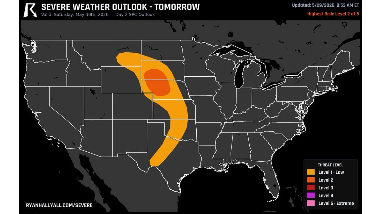
SOUTH DAKOTA AND NEBRASKA — The area around Rapid City, South Dakota and Ainsworth and Alliance, Nebraska has been identified as the most likely location in the entire United States to see large hail and damaging wind gusts on Saturday, May 30, 2026. A Level 2 out of 5 severe weather risk is centered over this corridor, with storms expected to develop during the afternoon hours.
The Risk Zone Breakdown
The Severe Weather Outlook updated at 8:53 AM ET on May 29, 2026 and valid for Saturday, May 30 shows a tightly focused threat area across the northern Plains:
Level 3 Core (Dark Red) — Highest Threat: Centered over the western Nebraska and southwestern South Dakota border region, this is the most concentrated area of severe weather risk in the country for Saturday. Communities sitting directly within or adjacent to this core include Rapid City, Ainsworth and Alliance, identified specifically as the spots most likely to see large hail and damaging winds.
Level 2 Zone (Orange) — Significant Threat: Surrounds the Level 3 core and extends the meaningful risk area across:
- Western and central South Dakota including the Black Hills region
- Northwestern Nebraska through the Sandhills
- Eastern Wyoming on the western fringe
- Northern Colorado on the southern edge
Level 1 Zone (Orange outer band) — Low but Real Risk: A broader crescent-shaped band stretches from Montana and North Dakota southward through Nebraska, Kansas and into Oklahoma and northern Texas, keeping a low-end severe weather possibility alive across a wide corridor of the central Plains.
What Storms Will Produce
Forecasters are specifically highlighting two primary hazards for Saturday’s storm event:
- Large hail as the most likely and significant threat across the Level 2 and Level 3 zones
- Damaging wind gusts capable of causing property damage and travel disruptions
The Level 2 storms are expected to develop during the afternoon hours, with activity building as daytime heating peaks across the western Nebraska and South Dakota target area.
Why Rapid City and the Nebraska Sandhills Are Ground Zero
The convergence of the incoming upper trough, strong atmospheric instability and a favorable wind shear profile places this specific geography at the center of Saturday’s severe weather setup. The Sandhills of Nebraska and the Black Hills region of South Dakota provide terrain features that can focus and enhance storm initiation, making Ainsworth, Alliance and Rapid City the specific communities most exposed to the worst of what Saturday’s storms produce.
What Residents Should Do Before Saturday Afternoon
- Have a weather alert device active and accessible
- Avoid outdoor activities in open areas during peak storm hours Saturday afternoon
- Secure vehicles away from hail exposure if possible
- Know your nearest sturdy shelter in case storms escalate beyond the current forecast
Stay with CabarrusWeekly.com for continuing updates as Saturday’s severe weather threat across South Dakota and Nebraska is tracked through the day.