Alabama Including Birmingham and Huntsville Faces First Alert Weather Day Monday as Organized Storm Line Brings Damaging Winds, Hail and Intense Lightning by 2 PM
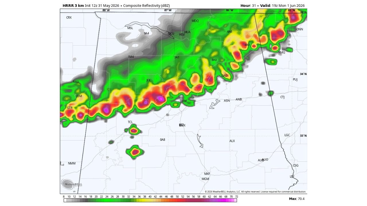
ALABAMA — A First Alert Weather Day has been declared for Monday, June 1, 2026 across Alabama, with a line of organized severe thunderstorms forecast to sweep through the state during the afternoon hours. The radar forecast valid at 19Z (2:00 PM CDT) on Monday, June 1 shows a powerful squall line stretching across northern and central Alabama, with damaging wind gusts, hail and intense lightning as the primary threats. Storms will be moving southward through the afternoon.
What the Forecast Radar Shows at 2 PM Monday
The composite reflectivity forecast shows a long and intense line of storms draped across Alabama from west to east by 2:00 PM Monday. The storm line features:
- Deep purple and pink cores indicating the most intense reflectivity values, with the map maximum reaching 70.4 dBZ
- The heaviest storm activity centered across a corridor running from Columbus and GTR in Mississippi eastward through Birmingham (BHM) and into central and northeast Alabama
- Huntsville (HSV) and the northern Alabama corridor under the northern edge of the line
- A secondary area of strong storms visible near Tuscaloosa (TCL) on the southwestern flank
- The storm line extends northeastward toward the Georgia border region
Timing: Afternoon Is the Main Window
The primary impact window for Monday is the afternoon hours, with the storm line expected to be pushing through central Alabama around 2:00 PM CDT. Storms will be tracking southward, meaning communities in northern Alabama will feel the impacts first before the line pushes into central and eventually southern portions of the state.
Primary Hazards Monday
Three hazards are specifically flagged for this First Alert Weather Day:
- Damaging wind gusts as the most likely and widespread threat with an organized squall line
- Hail possible with the stronger individual cells embedded within the line
- Intense lightning across the entire storm footprint as the line moves through
Cities and Communities Most at Risk
Based on the forecast radar positioning, the following communities are in the primary impact zone for Monday afternoon:
- Birmingham and the metro area
- Huntsville and Madison County
- Tuscaloosa
- Gadsden and northeast Alabama
- Communities along the I-20 and I-65 corridors through central Alabama
What Alabama Residents Should Do Before Monday Afternoon
- Complete any outdoor activities in the morning before storm arrival
- Have a weather alert method active and accessible throughout Monday
- Charge phones and prepare for possible power outages from damaging winds
- Know your shelter location before the line arrives
Stay with CabarrusWeekly.com for continuing updates as Monday’s First Alert Weather Day approaches across Alabama.