Kansas, Nebraska, Oklahoma and Texas Face Explosive Supercell and Tornado Potential as Major Pattern Shift Ignites the Plains June 1 Through June 14
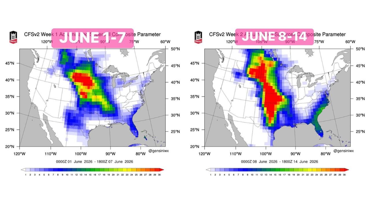
UNITED STATES — A major severe weather pattern shift is now underway across the central United States, with the Great Plains set to explode with supercell activity and tornado potential across two consecutive weeks spanning June 1 through June 14, 2026. The Accumulated Supercell Composite Parameter maps for both Week 1 (June 1 to 7) and Week 2 (June 8 to 14) show deep red cores across the central Plains, signaling one of the most significant severe weather setups of the 2026 season.
Week 1: June 1 to 7 Supercell Composite
The Week 1 map covering June 1 through June 7 shows an already impressive supercell environment taking shape:
- Deep red core centered over Kansas, Nebraska and Colorado, with values reaching the upper end of the composite scale
- Orange and yellow zones extending through Oklahoma, Texas, Missouri and Iowa
- A secondary elevated zone extending into the Tennessee Valley and mid-South
- The overall footprint covers the entire central Plains from the Dakotas southward into northern Texas
Week 2: June 8 to 14 Supercell Composite Goes Even Bigger
The Week 2 map covering June 8 through June 14 shows the pattern intensifying and expanding significantly:
- The deep red core broadens dramatically, now covering a larger area across Kansas, Nebraska, Oklahoma and into Missouri
- Red values extend northward into South Dakota and Iowa more aggressively than Week 1
- The threat corridor stretches from Montana and North Dakota all the way southward through Texas and into the Gulf Coast states
- The Southeast including Alabama, Mississippi and Georgia also shows elevated composite values on the Week 2 map
- Overall, Week 2 shows a more expansive and potentially more dangerous supercell environment than Week 1
What Is Driving This Pattern
Three large-scale atmospheric factors are combining to fuel what forecasters are calling a major severe weather stretch:
- A favorable phase of the Madden-Julian Oscillation (MJO) is enhancing convection across North America, providing the atmospheric energy needed to sustain organized storm systems
- An emerging super El Nino is strengthening the jet stream across the central United States, delivering the wind shear that supercells and long-track tornadoes require
- A warm phase North Pacific Oscillation (NPO) is contributing to the overall pattern configuration that pushes storm season deep into summer
Together these three drivers represent a textbook setup for an extended and active severe weather stretch across the Great Plains.
The States Most at Risk June 1 to 14
Based on the combined Week 1 and Week 2 composite maps, the states carrying the highest accumulated supercell potential across the full two-week period include:
- Kansas across the entire state
- Nebraska through the central and eastern portions
- Oklahoma through the northern and central regions
- Colorado along the eastern plains
- South Dakota and Iowa increasingly in Week 2
- Missouri and Arkansas in the eastern extension of the threat
What the Pattern Means for June
This two-week outlook represents a dramatic shift from the relatively quiet severe weather pattern of late May across the Plains. The combination of MJO support, El Nino shear enhancement and NPO forcing creates conditions where multiple significant severe weather events are possible within a single two-week window. Residents across the central Plains should treat June 1 through June 14 as an extended period of heightened weather awareness.
Stay with CabarrusWeekly.com for continuing coverage as this major severe weather pattern develops across the Great Plains through mid-June.