North Dakota, South Dakota and Nebraska Face Severe Thunderstorms and Flash Flooding Tuesday as Northern Plains Pattern Turns Active June 2
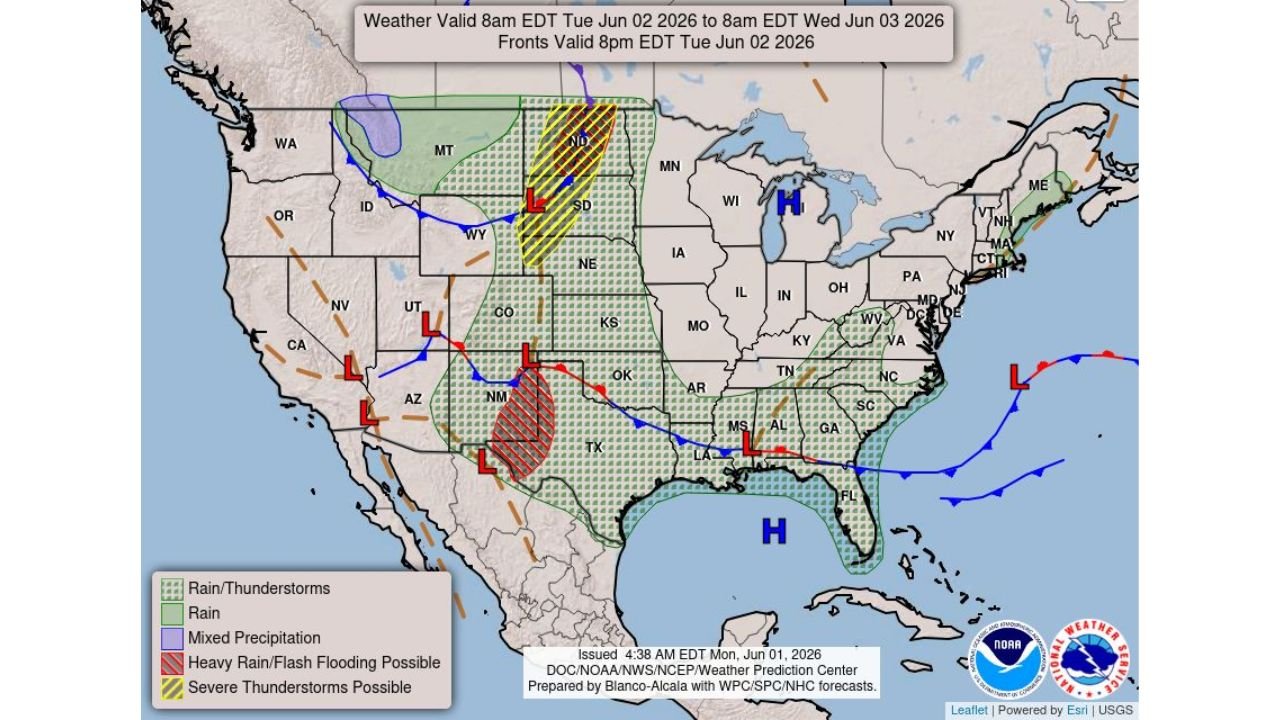
NORTH DAKOTA — Severe thunderstorms and flash flooding are both in the forecast for the northern Plains on Tuesday, June 2, 2026, with the Weather Prediction Center outlook valid from 8 AM EDT Tuesday through 8 AM EDT Wednesday flagging multiple hazard zones across the region. Large hail, damaging winds and possible tornadoes are all in play across the severe thunderstorm zone, while heavy to excessive rainfall threatens flooding across portions of the southern High Plains and North Dakota.
The Two Distinct Threat Zones
The WPC national weather map issued at 4:38 AM EDT on Monday, June 1, 2026 identifies two separate hazard areas across the central United States:
Severe Thunderstorm Zone (Yellow Hatching): Centered over western North Dakota, South Dakota and extending into Nebraska, this zone carries the risk of:
- Large hail
- Damaging winds
- Possible tornadoes
A surface Low pressure system is positioned over western South Dakota, providing the lift and wind shear needed to support severe storm development across this corridor on Tuesday.
Heavy Rain and Flash Flooding Zone (Red Hatching): A separate flash flooding threat is highlighted across eastern New Mexico and western Texas, where heavy to excessive rainfall from thunderstorm clusters could produce dangerous flooding across the southern High Plains. A second flooding concern also exists across North Dakota tied to the same system driving the severe weather threat.
The Broader Rain and Storm Footprint
Beyond the two highlighted hazard zones, a large area of rain and thunderstorms covers much of the central and eastern United States on Tuesday. The green shading on the map extends across:
- The central and southern Plains through Kansas, Oklahoma and into Texas
- The mid-South and Southeast including Arkansas, Mississippi, Alabama and into Florida
- The Mid-Atlantic and portions of New England
- A separate rain zone across the Pacific Northwest tied to a different system
A mixed precipitation zone in purple is visible across portions of Montana, associated with the same frontal boundary pushing through the northern tier.
Surface Weather Pattern Context
The map shows an active frontal pattern across the country on Tuesday:
- A cold front is draped from the northern Plains southward through the central United States
- Multiple Low pressure centers are positioned across the West, central Plains and the Southeast
- A strong High pressure system is anchored over the Great Lakes, keeping the northern tier relatively quiet east of the severe weather zone
- A High pressure dome over the Gulf of Mexico is keeping the Southeast warm and moist, fueling ongoing shower activity across Florida and the Gulf Coast states
Who Needs to Be Ready Tuesday
Residents across the following areas should prepare for active weather on Tuesday:
- Western North Dakota including the Bismarck area for both severe storms and flooding
- Western and central South Dakota for severe thunderstorm potential
- Nebraska on the southern end of the severe zone
- Eastern New Mexico and the Texas Panhandle for flash flooding risk
Stay with CabarrusWeekly.com for continuing updates as Tuesday’s severe weather and flooding threat develops across the northern Plains and southern High Plains.