Gulf Moisture Surge Sets Up Multi-State Storm Risk From Texas to North Carolina Late Next Week
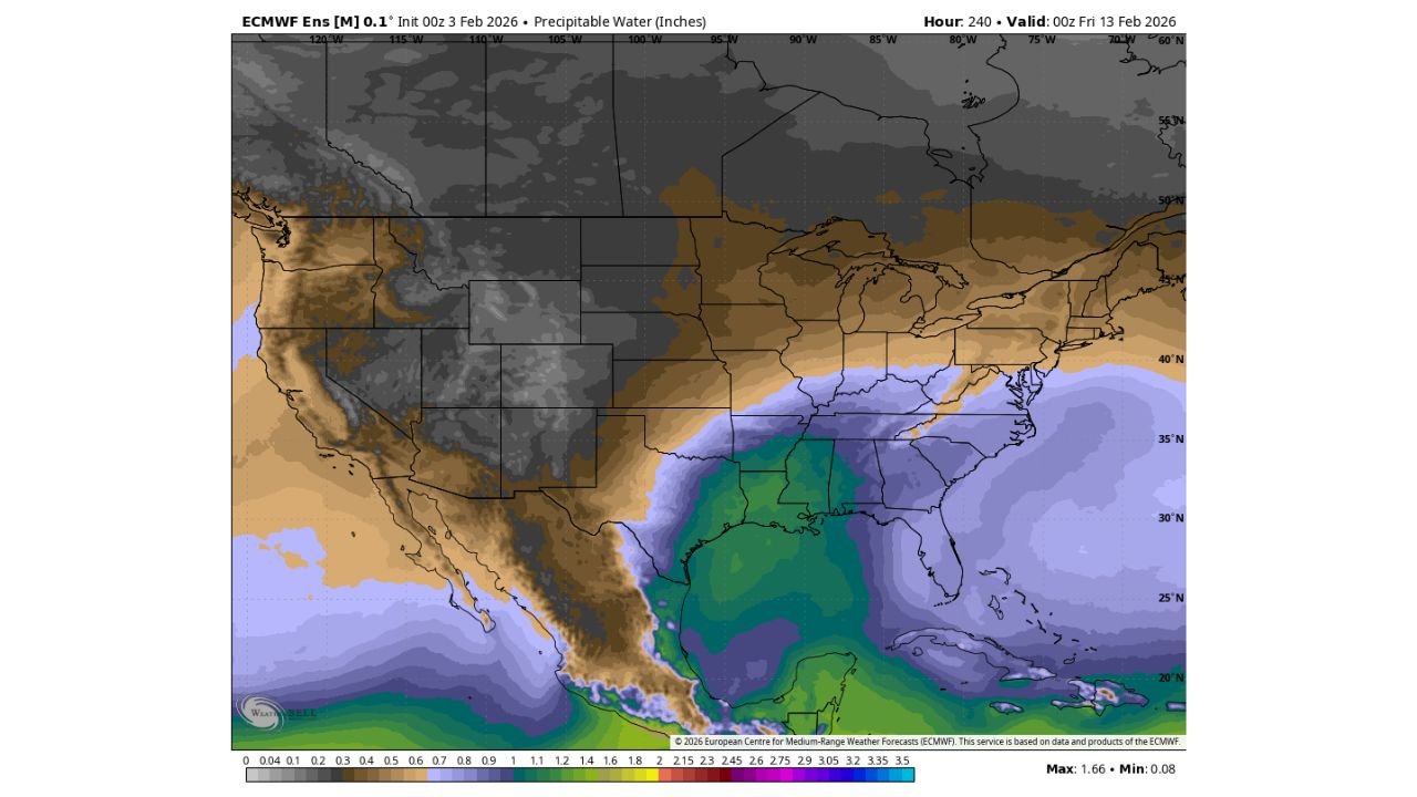
UNITED STATES — New ECMWF ensemble precipitable water guidance, valid 00z Friday, February 13, shows a large and organized surge of atmospheric moisture lifting north out of the Gulf of Mexico and spreading across multiple U.S. states, a setup that historically increases the risk for widespread rain and stormy weather where forcing becomes available.
Core Moisture Source Located Over the Gulf of Mexico
The highest precipitable water values on the map are concentrated over the central and western Gulf of Mexico, with deep moisture extending northward into Mexico’s eastern coastline and the Texas Gulf Coast.
This signals a well-established moisture reservoir, not a shallow or transient feature. When moisture values reach this scale and coverage, it often supports high rainfall efficiency once storms develop.
Southern States Directly Impacted by Moisture Expansion
From the Gulf, elevated moisture values spread inland across:
- Texas
- Louisiana
- Mississippi
- Alabama
These states sit beneath the core moisture plume, indicating the potential for widespread rain or thunderstorms depending on how frontal boundaries and upper-level energy align during this period.
Southeast Corridor Extends Into Georgia and South Carolina
The ensemble data shows the moisture plume continuing east and northeast into:
- Georgia
- South Carolina
Moisture levels here remain notably higher than climatological February averages, which increases the risk of organized rain bands and embedded convection, especially if a low-pressure system tracks through the region.
Moisture Reaches North Carolina and Virginia by Feb. 13
By the valid time, North Carolina and southern Virginia are included within the expanded moisture field. While values are slightly lower than those closer to the Gulf, they are still elevated enough to support:
- Moderate to heavy rainfall
- Thunderstorms
- Multiple rounds of precipitation if storms repeat over the same areas
This is a key point for central and eastern North Carolina, including the Piedmont, where Gulf-fed systems can produce impactful rainfall even without severe weather.
Sharp Moisture Gradient Sets Up Potential Storm Boundary
A clear gradient exists between drier air over the western United States and very moist air across the South and Southeast. This contrast is important because strong moisture gradients often align with:
- Frontal boundaries
- Jet stream disturbances
- Surface low development
Those features are common storm triggers when moisture is already in place.
Why This Pattern Raises Storm Potential
Precipitable water does not create storms by itself, but it defines how much rain storms can produce once they form. With moisture levels this high across multiple states at the same time, the environment becomes favorable for:
- Efficient rainfall production
- Training storms
- Localized flooding
- Long-duration rain events
If a strong disturbance moves through the southern or southeastern U.S. during this window, impacts could escalate quickly.
Timing Window Highlighted by the Data
The ensemble frame focuses on late next week, centered around Friday, February 13. This does not lock in a single event, but it clearly identifies a higher-risk atmospheric setup across:
- Texas
- Louisiana
- Mississippi
- Alabama
- Georgia
- South Carolina
- North Carolina
- Virginia
Bottom Line Based Strictly on the Data
The ECMWF ensemble moisture forecast shows a textbook Gulf moisture surge expanding into the Southeast and Mid-Atlantic by mid-February. This pattern significantly raises the ceiling for stormy and wet weather across multiple states, including North Carolina, should a storm system move through during this period.