From Near 90 to the 50s in Days: Baltimore and the Mid-Atlantic Face a Dramatic 40-Degree Temperature Crash After Wednesday and Thursday’s Peak Heat
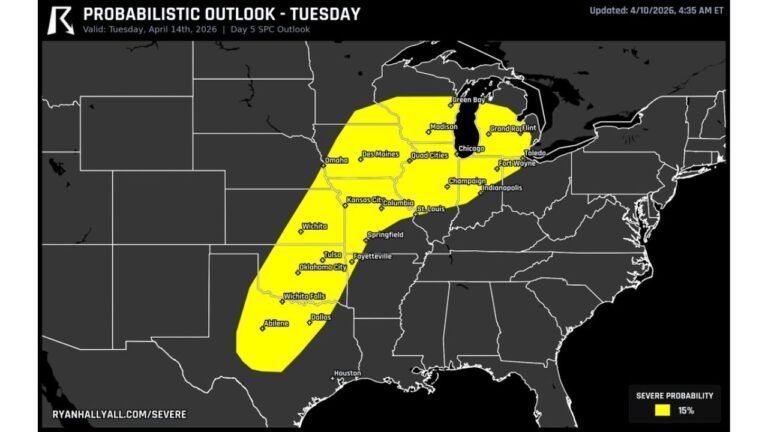
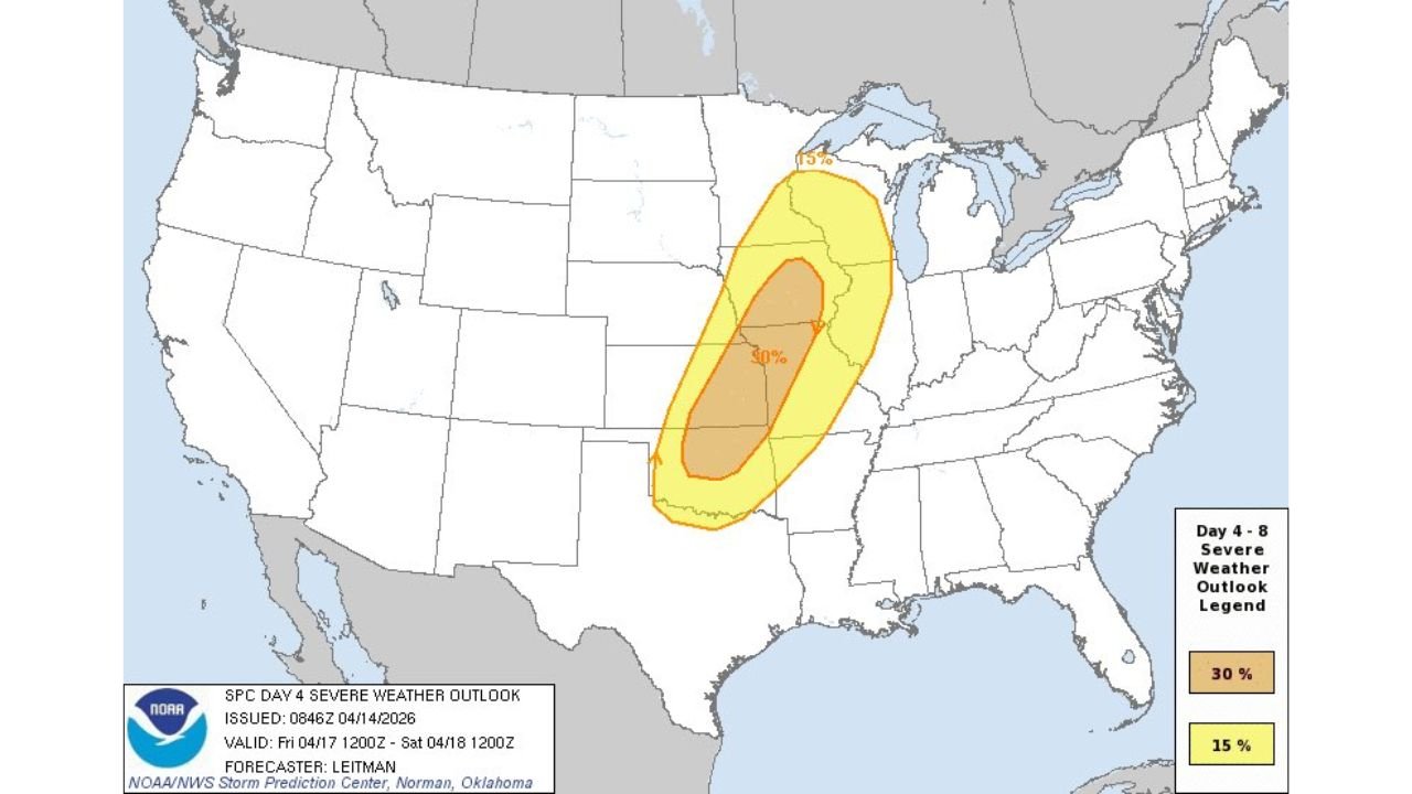
PLAINS AND MIDWEST, UNITED STATES — Before Tuesday’s tornado outbreak has even finished, the Storm Prediction Center is already looking ahead — and what they are seeing for Friday and Saturday is another potentially significant severe weather event across parts of the Plains and Midwest. The SPC has issued formal Day 4 and Day 5 severe weather outlooks for Friday April 17 and Saturday April 18, 2026, outlining a 30% severe weather probability for Friday and a 15% severe weather probability for Saturday — with both days potentially featuring all severe hazards. The active pattern is not done.
Two More Days of Severe Weather Already Outlined — Friday and Saturday
Both outlooks were issued April 14, 2026 at 08:46Z by forecaster Leitman at the NOAA NWS Storm Prediction Center in Norman, Oklahoma. The fact that SPC is already issuing formal probability outlooks at the Day 4 and Day 5 range for a region that just endured a major tornado outbreak reflects the extraordinary persistence of the active severe weather pattern across the central United States this week.
Friday April 17 — The Day 4 Outlook: 30% Severe Probability
The SPC Day 4 Severe Weather Outlook, valid from Friday April 17, 2026 at 12:00Z through Saturday April 18, 2026 at 12:00Z, shows a well-defined severe weather probability zone covering a large corridor across the central United States.
| Probability Zone | Coverage |
|---|---|
| 30% severe weather probability | Core zone — central Plains through central Midwest corridor |
| 15% severe weather probability | Broader surrounding zone — expanded area across Plains, Midwest, and Great Lakes |
The 30% core zone covers a defined oval sitting across the central portion of the country — stretching from the central Plains northeast through the Midwest. The 15% surrounding zone fans out broadly around the core, covering a much wider area that includes portions of the Great Lakes to the north.
A 30% severe weather probability at Day 4 is a significant and meaningful signal. At this range, the SPC is expressing genuine confidence that a severe weather event will materialize on Friday — not a marginal or uncertain signal, but a defined and elevated probability that forecasters are willing to issue formally four days out.
Both Friday’s all severe hazards designation means that damaging winds, large hail, and tornadoes are all on the table for the 30% zone when Friday arrives.
Saturday April 18 — The Day 5 Outlook: 15% Severe Probability
The SPC Day 5 Severe Weather Outlook, valid from Saturday April 18, 2026 at 12:00Z through Sunday April 19, 2026 at 12:00Z, shows a tighter but still significant severe weather probability zone that has shifted east compared to Friday’s setup.
| Probability Zone | Coverage |
|---|---|
| 15% severe weather probability | Core zone — Illinois and Indiana corridor, extending toward Michigan and Ohio |
The 15% zone for Saturday is centered on a defined oval covering Illinois and Indiana, reaching north toward Michigan and east toward Ohio. The geographic shift from Friday’s broader Plains and Midwest zone to Saturday’s more focused Illinois and Indiana corridor reflects the expected eastward progression of the storm system through the weekend.
Like Friday, Saturday’s outlook also features all severe hazards — meaning damaging winds, large hail, and tornadoes are all possible from whatever severe weather develops across Illinois and Indiana on Saturday.
The Pattern Is Not Resting — This Is a Multi-Day Outbreak Sequence
The issuance of these Day 4 and Day 5 outlooks while Tuesday’s outbreak is still ongoing is a clear signal that the atmospheric pattern driving severe weather across the Plains and Midwest is entrenched and not going anywhere through at least the end of the week.
The sequence as it currently stands:
| Day | Severe Weather Status |
|---|---|
| Tuesday April 14 | Active major tornado outbreak — 45 million people at risk |
| Wednesday April 15 | Continued severe weather threat across the Plains and Midwest |
| Thursday April 16 | Transition period |
| Friday April 17 | 30% severe probability — all hazards — Plains and Midwest |
| Saturday April 18 | 15% severe probability — all hazards — Illinois and Indiana |
This is a week-long severe weather sequence across the same general corridor — the Plains, Midwest, and Great Lakes — with no significant break in the pattern through the weekend.
What All Severe Hazards Means for Friday and Saturday
The all severe hazards designation for both Friday and Saturday is not boilerplate language. It specifically means that forecasters are not ruling out any of the three primary severe weather categories for either day:
| Hazard | Friday April 17 | Saturday April 18 |
|---|---|---|
| Damaging winds | Possible — all hazards in play | Possible — all hazards in play |
| Large hail | Possible — all hazards in play | Possible — all hazards in play |
| Tornadoes | Possible — all hazards in play | Possible — all hazards in play |
The specific mix of hazards, the geographic precision of the threat zones, and the intensity of any tornado potential will become much clearer as the Day 3, Day 2, and Day 1 outlooks are issued for Friday and Saturday in the coming days.
Friday and Saturday Severe Weather Outlook Summary
| Factor | Friday April 17 | Saturday April 18 |
|---|---|---|
| Outlook type | SPC Day 4 | SPC Day 5 |
| Issued | April 14, 2026 at 08:46Z | April 14, 2026 at 08:46Z |
| Forecaster | Leitman — NWS SPC Norman | Leitman — NWS SPC Norman |
| Valid period | Fri April 17 12Z — Sat April 18 12Z | Sat April 18 12Z — Sun April 19 12Z |
| Core probability | 30% | 15% |
| Outer probability | 15% | — |
| Primary zone | Central Plains through central Midwest | Illinois and Indiana corridor |
| Secondary zone | Broader Plains, Midwest, Great Lakes | Michigan and Ohio outer zone |
| Hazard designation | All severe hazards | All severe hazards |
| Upgrade potential | Yes — as models refine Thursday | Yes — as models refine Friday |
The Week That Will Not End — What Comes Next
Tuesday’s outbreak is historic. Wednesday brings another round. And now Friday and Saturday are already carrying formal SPC severe weather probabilities for the same battered corridor across the Plains and Midwest. This is one of the most sustained and active severe weather sequences the central United States has seen in years.
Residents across the Plains, Midwest, and Great Lakes who have already endured Tuesday’s outbreak need to understand that the pattern is not finished. Friday’s 30% severe probability and Saturday’s 15% probability covering Illinois and Indiana represent the next chapter in a week-long severe weather sequence — and both days carry the potential for all severe hazards, including tornadoes.
Watch for upgrades to Friday and Saturday’s outlooks as the week progresses and model guidance sharpens. What begins as a 30% and 15% probability today could evolve significantly by the time Thursday and Friday morning outlooks are issued.
Stay with CabarrusWeekly.com for ongoing severe weather coverage through the end of the week, daily SPC outlook updates for Friday and Saturday, and complete tracking of the multi-day severe weather sequence across the Plains and Midwest through the weekend.