Illinois, Indiana and Missouri Face Two Dangerous Storm Waves Monday With Tornadoes, Very Large Hail and Damaging Winds Through Overnight
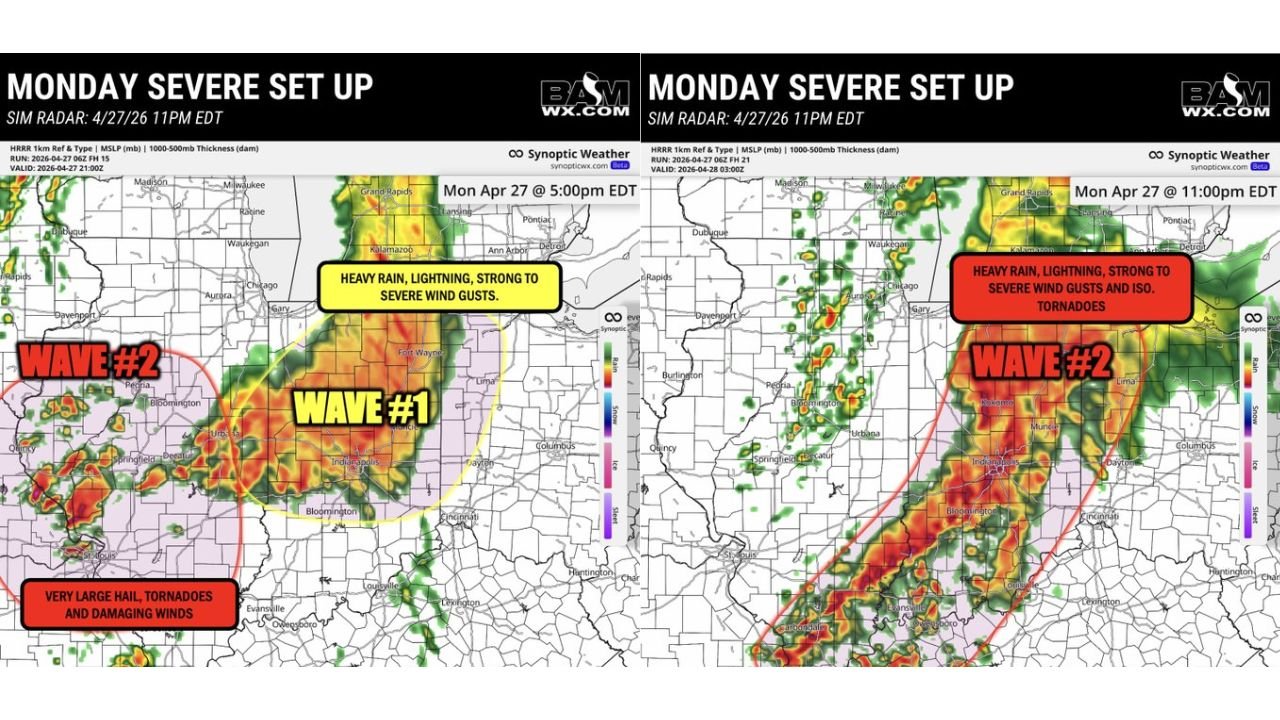
ILLINOIS, INDIANA AND MISSOURI — Two distinct and dangerous waves of severe storms are tracking through Illinois, Indiana, and Missouri on Monday, April 27, 2026, with Wave 1 already pushing through Indiana bringing heavy rain and damaging winds, and Wave 2 developing across Illinois and Missouri this evening carrying very large hail, tornadoes, and damaging winds before pushing into Indiana overnight.
Wave 1 — Heavy Rain, Lightning and Severe Wind Gusts
As of 5:00 PM EDT, Wave 1 is pushing through a broad corridor from northern Indiana through Fort Wayne, Indianapolis, and southward toward Bloomington. This wave is primarily a heavy rain and lightning event, but strong to severe wind gusts are possible with the more organized cells embedded within the line. The overall tornado threat with this wave is lower, but damaging gusts remain a real concern through the early evening hours.
Wave 2 — The More Dangerous of the Two
Wave 2 is the significantly more dangerous system. Currently developing across Illinois and Missouri this evening, this wave carries the full suite of severe weather hazards:
- Very large hail
- Tornadoes — including potentially strong tornadoes within the most organized cells
- Damaging straight-line winds
As Wave 2 tracks east overnight toward Indiana, it is expected to transition into a squall line — a long, organized line of storms — with the primary threat shifting toward damaging wind gusts and isolated tornadoes as it pushes through Indiana into the overnight hours.
Storm Wave Timeline
| Wave | Location at 5 PM EDT | Location at 11 PM EDT | Primary Threats |
|---|---|---|---|
| Wave 1 | Northern and central Indiana | Moving east out of Indiana | Heavy rain, lightning, severe wind gusts |
| Wave 2 | Illinois and Missouri | Pushing into Indiana — Kokomo, Muncie, Indianapolis, Louisville corridor | Very large hail, tornadoes, damaging winds, isolated tornadoes overnight |
What Wave 2 Looks Like at 11 PM EDT
The simulated radar valid for 11:00 PM EDT Monday shows Wave 2 pushing into a corridor spanning northern Indiana through Indianapolis, Bloomington, and Louisville, with intense reflectivity cores stretching from Kokomo and Muncie through central Indiana and into western Kentucky. The threat at this stage shifts more toward heavy rain, severe wind gusts, and isolated tornadoes as the squall line consolidates.
Who Needs to Be Alert Through Tonight
Right now through early evening: Residents across Illinois and Missouri are in the most dangerous window for Wave 2 tornadoes and very large hail. Get to shelter before storms arrive.
This evening through overnight: Residents across Indiana — including Indianapolis, Kokomo, Muncie, Bloomington, Fort Wayne, and surrounding areas — need to maintain overnight alert capability. Wave 2 will be pushing through during the late evening and overnight hours when many people are asleep.
- Keep a weather radio or alert-enabled phone active overnight
- Do not assume the threat is over after Wave 1 passes
- Mobile homes offer no protection from either wave
Stay with CabarrusWeekly.com for continuous live coverage through tonight’s two-wave severe weather event.