Morning Storms Already Building Across Northern Illinois and Northern Indiana — Locally Heavy Rain, Large Hail Risk, and Lightning Pushing Eastward Toward Chicago, Gary, Fort Wayne, and Beyond
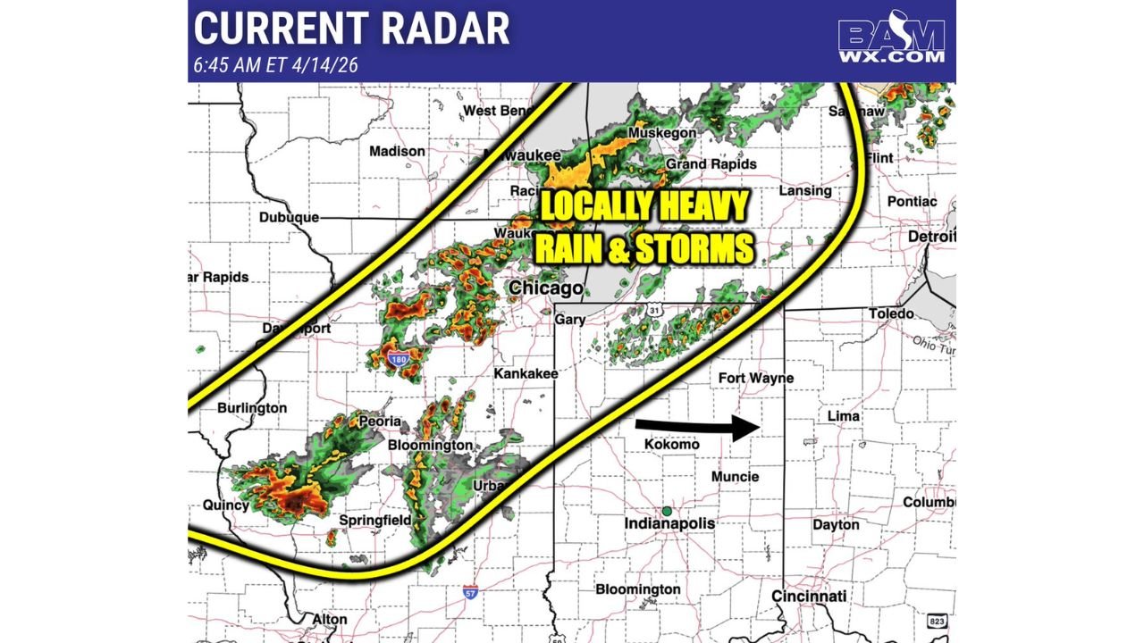
NORTHERN ILLINOIS AND NORTHERN INDIANA — Tuesday April 14, 2026 is not waiting until the afternoon to get active. Rain and storms are already building this morning across northern Illinois and northern Indiana, and the current radar at 6:45 AM ET shows a well-defined corridor of active precipitation pushing eastward across the region. Locally heavy rain, an isolated strong to severe storm, large hail, and lightning are all possible over the next few hours as this morning activity moves east — and this is all happening before the far more dangerous afternoon and evening tornado threat window even opens.
What Radar Shows at 6:45 AM ET — April 14, 2026
The current radar snapshot from BAMWX at 6:45 AM ET captures a broad corridor of rain and storms already active across northern Illinois and northern Indiana, labeled clearly as producing locally heavy rain and storms across the region. The storm activity is organized across a defined zone and is moving eastward — the direction of push over the next few hours.
| Area | Radar Status at 6:45 AM ET |
|---|---|
| Northern Illinois — Peoria, Bloomington, Urbana, Springfield | Active rain and storm cells — some intense red and orange returns visible |
| Chicago corridor | Inside the active storm zone — locally heavy rain ongoing |
| Gary, Indiana | Active storm corridor pushing through |
| Davenport, Iowa | On the western edge of the active zone |
| Kankakee, Illinois | Inside the rain and storm corridor |
| Muskegon, Michigan — Grand Rapids area | Storm activity visible pushing northeast |
| West Bend, Waukee, Racine, Wisconsin | Active precipitation on the northern edge |
| Lansing, Flint, Pontiac, Michigan | Ahead of the moving corridor — approaching activity |
| Fort Wayne, Indiana | Ahead of the eastward push — storms approaching |
| Kokomo, Indiana | Storm activity approaching from the west — arrow pointing east |
| Indianapolis, Indiana | Southern edge of the corridor — storms possible as system pushes east |
| Toledo, Ohio | Ahead of the eastward push |
The most intense radar returns — showing red and orange on the radar mosaic — are visible across portions of northern Illinois near Peoria, Bloomington, and the Quincy area, indicating pockets of heavier rainfall and more organized storm activity within the broader rain corridor.
The Hazards This Morning — Before the Afternoon Threat Arrives
This morning’s storm activity carries its own set of hazards that are separate from the far more dangerous afternoon and evening tornado threat. For the next few hours as this system pushes east, residents across northern Illinois, northern Indiana, and the surrounding corridor need to be aware of:
Large Hail — The Primary Morning Hazard An isolated strong to severe storm is possible within today’s morning activity, and the primary hazard from any storm that strengthens is large hail. Vehicles, windows, and anyone caught outdoors when hail begins falling need to take cover immediately.
Locally Heavy Rain The radar is already showing pockets of locally heavy rainfall across the northern Illinois corridor. As this activity pushes east through Chicago, Gary, Fort Wayne, Kokomo, and Indianapolis, locally heavy rain pockets will continue to produce brief periods of reduced visibility and potential standing water on roadways.
Lightning Active thunderstorm cells within the morning corridor are producing lightning across the region. Anyone outdoors in northern Illinois or northern Indiana this morning should seek shelter immediately when thunder is heard — lightning from morning storm cells is as dangerous as lightning from any other thunderstorm regardless of the time of day.
The Eastward Push — Where Storms Are Heading
The storm corridor is moving eastward over the next few hours, as shown by the directional arrow on the radar map pointing east toward Kokomo, Indiana and beyond. Cities that are currently dry but sit ahead of the moving storm corridor should expect conditions to deteriorate through the mid-morning hours.
| City | Current Status | What’s Coming |
|---|---|---|
| Chicago, Illinois | Inside active corridor | Continued locally heavy rain and storms |
| Gary, Indiana | Inside active corridor | Continued rain and storm activity |
| Fort Wayne, Indiana | Ahead of corridor | Rain and storms approaching from the west |
| Kokomo, Indiana | Ahead — arrow points here | Active weather arriving within hours |
| Indianapolis, Indiana | Southern edge | Rain and storm activity possible as system pushes east |
| Toledo, Ohio | Ahead of the push | Morning activity approaching |
| Lansing, Michigan | Northern corridor | Storm activity pushing northeast |
| Flint and Pontiac, Michigan | Ahead of corridor | Activity approaching from the west |
| Cincinnati, Ohio | Southern edge | Monitoring as system moves east |
| Dayton, Ohio | Ahead | Watching the eastward push |
This Is the Morning — The Afternoon Is Far More Dangerous
It is critical to understand that this morning’s storm activity is separate from and less dangerous than what is forecast for this afternoon and evening. The far northern Illinois and southern Wisconsin tornado threat — where several tornadoes are likely with some potentially reaching EF-3 or stronger from 3 PM through 10 PM — has not yet begun.
This morning’s activity across northern Illinois and northern Indiana represents the early hours of a very long and dangerous severe weather day. Residents should not allow the morning rain and storms to create complacency about the afternoon threat — the two events are distinct, and the afternoon window carries catastrophically greater tornado potential than anything occurring this morning.
The morning brings locally heavy rain and a large hail risk. The afternoon brings the EF-3-plus tornado threat. Both demand attention — on completely different scales.
Morning Severe Weather Summary — 6:45 AM ET
| Factor | Details |
|---|---|
| Radar time | 6:45 AM ET — Tuesday April 14, 2026 |
| Active storm area | Northern Illinois and northern Indiana |
| Storm movement | Eastward — pushing toward Fort Wayne, Kokomo, Indianapolis, Toledo |
| Primary morning hazard | Large hail — isolated strong to severe storm possible |
| Additional hazards | Locally heavy rain, lightning |
| Cities currently active | Chicago, Gary, Peoria, Bloomington, Kankakee, Muskegon, Grand Rapids |
| Cities in the path | Fort Wayne, Kokomo, Indianapolis, Lansing, Flint, Toledo |
| Afternoon threat | Separate and far more dangerous — EF-3-plus tornado risk 3 PM to 10 PM |
Take the Morning Seriously — But Stay Ready for the Afternoon
Rain and storms are already moving through northern Illinois and northern Indiana this Tuesday morning, bringing locally heavy rain, large hail potential, and lightning to the Chicago, Gary, Peoria, Bloomington, and surrounding corridor. As this activity pushes east through Fort Wayne, Kokomo, and Indianapolis over the next few hours, conditions will deteriorate across those areas as well.
Stay weather aware this morning — but do not let the morning activity distract from the preparation needed for this afternoon. The 3 PM to 10 PM tornado threat window across far northern Illinois and southern Wisconsin is still coming, and it is far more dangerous than anything occurring before noon today. Use the morning hours to finalize your tornado shelter plan, charge your devices, and ensure all alert systems are active before 3 PM.
Stay with CabarrusWeekly.com for morning radar updates across northern Illinois and northern Indiana, and live coverage of the far more dangerous afternoon and evening tornado threat as the 3 PM window approaches across the region.