Indiana and Illinois Face Morning Rain Showers With 40 MPH Gusty Winds, Lightning and Heavy Rainfall Near Indianapolis, Lafayette and Terre Haute Friday May 15 Through Mid Morning
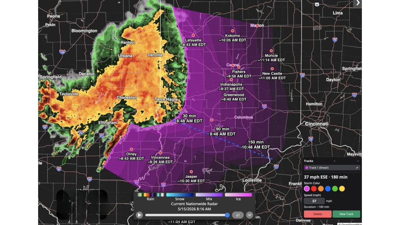
INDIANAPOLIS, INDIANA — A line of rain showers is pushing through Indiana and Illinois this Friday morning May 15, 2026, with the best chance for lightning, heavier rainfall, and gusty winds up to 40 MPH south of the main frontal boundary. Arrival times are already tracked for several cities across the region.
Storm Arrival Times Friday Morning
| City | Estimated Arrival |
|---|---|
| Lafayette and Olney | 8:43 AM EDT |
| Terre Haute | Ongoing at 8:16 AM EDT |
| Indianapolis | 9:37 AM EDT |
| Greenwood | 9:40 AM EDT |
| Vincennes | 9:26 AM EDT |
| Fishers | 9:58 AM EDT |
| New Castle | 11:05 AM EDT |
| Kokomo | 10:05 AM EDT |
| Jasper | 10:30 AM EDT |
| Muncie | 11:14 AM EDT |
Where the Strongest Conditions Are Expected
The heaviest rain, lightning, and gusty winds up to 40 MPH will be focused south of the blue dashed line, placing Indianapolis, Greenwood, Terre Haute, Vincennes, and Jasper in the highest risk zone for the strongest conditions.
Areas north of the boundary including Kokomo, Lafayette, and Muncie will see lighter rain with less lightning and wind activity.
System Exits by Mid Morning
The storm line is moving at 37 MPH to the east-southeast and is expected to clear most of central Indiana by around 11:04 AM EDT, making this a fast-moving but impactful morning system.
Stay with CabarrusWeekly.com for live updates as this morning storm line moves through Indiana and Illinois.