Southern and Eastern States Face Up to 4 Inches of Rain Through May 20 With Baltimore Reservoirs Running Critically Low
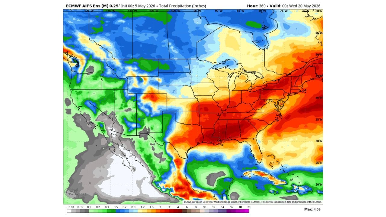
SOUTHERN AND EASTERN UNITED STATES — The most active weather pattern over the next two weeks will be concentrated across the Southern and Eastern United States, with ensemble precipitation guidance valid through Wednesday, May 20, 2026 showing widespread heavy rainfall totals across a broad corridor from the Deep South through the Mid-Atlantic and Northeast, peaking at a maximum of 4.09 inches across the most active zones.
Southern and Eastern US Face the Heaviest 2-Week Totals
The two-week total precipitation map shows the deepest red and orange shading — indicating the highest rainfall amounts — concentrated across:
- Deep South and Gulf Coast — heaviest totals in the 6 to 10 inch range across the core
- Mid-Atlantic corridor including Maryland, Virginia and the Carolinas — 4 to 8 inches
- Great Lakes and Ohio Valley — 2 to 4 inches
- Northeast corridor — 3 to 6 inches
The Western United States, Central Plains and upper Midwest show significantly lighter totals, with much of the interior West remaining dry through the period.
Baltimore and Maryland Reservoirs Dangerously Low
The upcoming active pattern comes at a critical time for Maryland. Reservoir and groundwater levels across parts of Maryland including the Baltimore metro are running critically low following an extended dry stretch. The next meaningful rain chance for the Baltimore area arrives on Wednesday, May 6, offering the first opportunity to begin chipping away at the growing water deficit.
2-Week Rainfall Outlook by Region Through May 20
| Region | 2-Week Total Forecast |
|---|---|
| Deep South Gulf Coast core | 6.0 to 10.0 inches |
| Mid-Atlantic including Maryland | 4.0 to 8.0 inches |
| Carolinas and Virginia | 4.0 to 7.0 inches |
| Great Lakes and Ohio Valley | 2.0 to 4.0 inches |
| Northeast corridor | 3.0 to 6.0 inches |
| Central and Northern Plains | 0.5 to 2.0 inches |
| Western United States | Largely dry, under 1.0 inch |
Western US Stays Largely Dry Through the Period
While the East gets soaked over the next two weeks, the Western United States remains on the dry side of the pattern. Blue shading indicating above normal precipitation is limited to scattered portions of the Pacific Northwest and far northern Rockies, while the Southwest and central West stay well below normal through May 20.
Stay with CabarrusWeekly.com for continuing updates on the two-week precipitation outlook across the Southern and Eastern United States.