Texas Arkansas and Louisiana Facing Life-Threatening Flooding Over the Next Week With Up to 8 Inches of Rain Targeting Lufkin Shreveport Houston San Antonio and Tyler Through Wednesday May 27
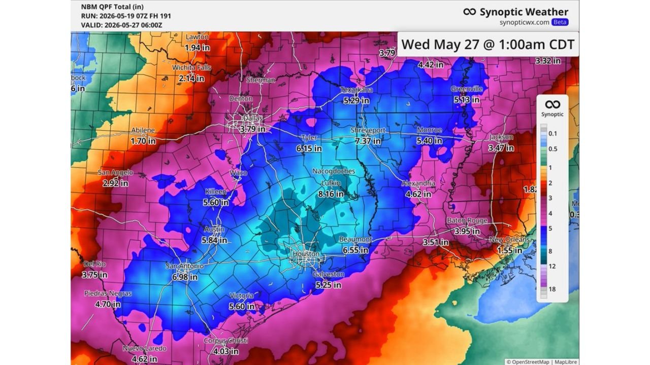
TEXAS, ARKANSAS AND LOUISIANA — A significant and dangerous rainfall event is unfolding across Texas, Arkansas, and Louisiana over the next week, with forecast totals showing multiple locations receiving 6 inches or more of rain through Wednesday, May 27, 2026 at 1:00 AM CDT. Forecasters warn this level of rainfall will likely lead to flooding across the region.
The Rainfall Totals Are Alarming Across a Wide Area
The forecast rainfall map through May 27 is showing an extraordinary accumulation of precipitation spread across eastern Texas, northwestern Louisiana, and southern Arkansas. The core of the heaviest rain is centered over east Texas, where totals are forecast to be the most extreme of the entire event.
City by City Rainfall Forecast Through May 27
| City | Forecast Rainfall Total |
|---|---|
| Lufkin, Texas | 8.16 inches |
| Shreveport, Louisiana | 7.37 inches |
| San Antonio, Texas | 6.98 inches |
| Houston, Texas | 6.55 inches |
| Beaumont, Texas | 6.55 inches |
| Tyler, Texas | 6.15 inches |
| Austin, Texas | 5.84 inches |
| Killeen, Texas | 5.60 inches |
| Victoria, Texas | 5.60 inches |
| Texarkana, Texas | 5.29 inches |
| Galveston, Texas | 5.25 inches |
| Monroe, Louisiana | 5.40 inches |
| Greenville, Texas | 5.13 inches |
| Alexandria, Louisiana | 4.62 inches |
| Corpus Christi, Texas | 4.03 inches |
| Baton Rouge, Louisiana | 3.95 inches |
| Dallas, Texas | 3.79 inches |
| Jackson, Mississippi | 3.47 inches |
| San Angelo, Texas | 2.92 inches |
| Wichita Falls, Texas | 2.14 inches |
Flooding Is the Primary Danger
With multiple locations forecast to receive 6 to 8 inches of rain spread across the next week, the cumulative impact on waterways, drainage systems, and low-lying areas will be severe. Flash flooding and river flooding are the primary concerns across the entire affected corridor. Even areas receiving lower totals in the 3 to 4 inch range face meaningful flood risk given the extended duration of the wet pattern.
The Timeline Residents Need to Know
This rainfall is not a single-day event. The forecast is valid through Wednesday, May 27 at 1:00 AM CDT, meaning communities across Texas, Arkansas, and Louisiana will face repeated rounds of heavy rain over multiple days. This extended duration makes flood conditions particularly dangerous, as ground saturation will increase with each successive round of rainfall.
What Residents Must Do Now
Anyone living across the affected corridor from south Texas through east Texas into Louisiana and Arkansas should begin flood preparation immediately. Know your local flood evacuation routes, avoid low-water crossings at all times during and after rainfall, and monitor conditions closely through the end of May.
Stay with CabarrusWeekly.com for continuous flood and rainfall updates through this dangerous multi-day weather event.