Texas, Oklahoma, Kansas, Iowa, Wisconsin and Minnesota Face a Large Severe Weather Outbreak With Multiple Tornadoes, Very Large Hail and Damaging Winds Likely From Wichita to Minneapolis Monday May 18
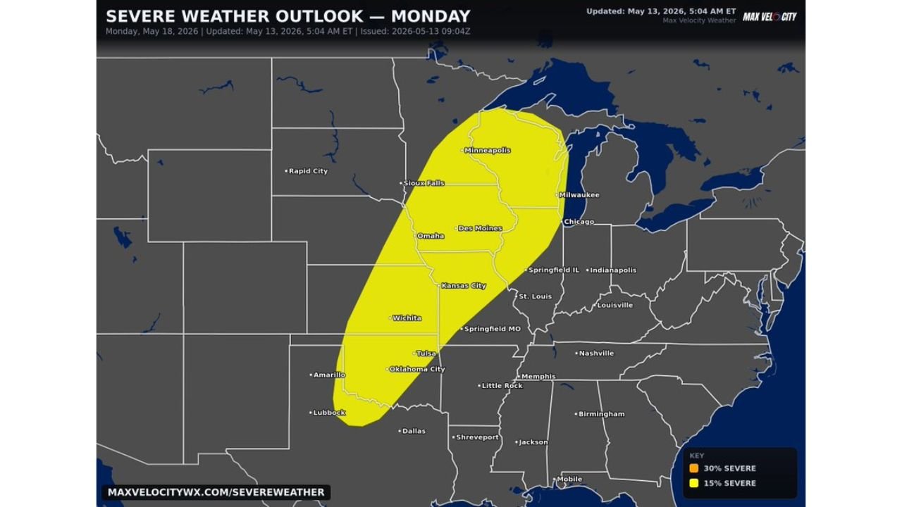
KANSAS — A large severe weather event is expected Monday May 18, 2026, with very large hail, damaging winds, and multiple tornadoes likely across a massive corridor stretching from Texas to Wisconsin. The outlook updated at 5:04 AM ET on May 13, 2026 shows a broad severe weather threat zone that could lead to a full severe weather outbreak.
Threat Zone Stretches From Texas to Minnesota
The severe weather outlook map shows two distinct risk zones for Monday:
15% Severe Risk zone covers:
- Minneapolis, Sioux Falls, Omaha, Des Moines
- Kansas City, Wichita, Oklahoma City, Tulsa
- Milwaukee and Chicago on the eastern edge
30% Severe Risk zone — elevated core centered over:
- Omaha, Des Moines, Kansas City, and Wichita — the highest risk corridor for Monday
Cities including Dallas, Lubbock, Amarillo, St. Louis, Indianapolis, and Nashville sit outside the current threat area.
All Major Hazards on the Table
- Multiple tornadoes — likely across the corridor
- Very large hail — widespread threat
- Damaging winds — expected with any supercell development
- Severe weather outbreak possible — per the outlook language
This Is a High-Impact Event — Prepare Now
With this event still days away, now is the time to prepare. If you are anywhere from Texas through Wisconsin and Minnesota, review your severe weather shelter plan and monitor forecasts closely as Monday approaches.
Stay with CabarrusWeekly.com for daily updates as this major Monday severe weather outbreak threat continues to develop.