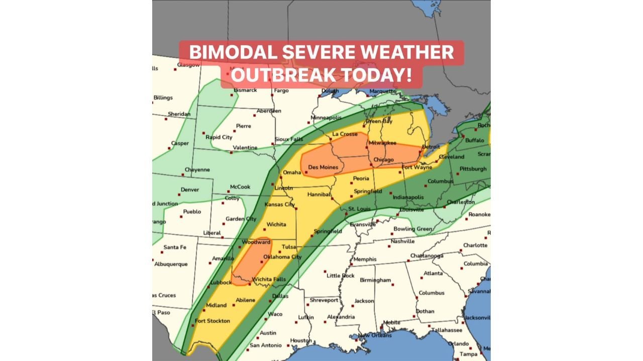
Two Separate Tornado Outbreaks Firing Simultaneously Today: EF2-Plus Tornadoes Threaten Eastern Iowa, Northern Illinois, and Southern Wisconsin by 4 PM While Oklahoma and North Texas Face a Ramping Tornado Threat After Dark
UNITED STATES — Today is not a single severe weather event. It is two simultaneous tornado outbreaks firing at opposite ends of the country at the same time — a bimodal severe weather outbreak that splits the nation’s attention and its danger across two completely separate corridors. EF2-plus tornadoes are the great threat across eastern Iowa, northern Illinois, and southern Wisconsin starting as early as 4 PM this afternoon. Simultaneously, a southern mode of supercells and tornadoes is ramping up across Oklahoma into North Texas — with the tornado threat there intensifying during the evening hours as the low-level jet kicks in. Professional storm intercept teams are deploying in full today for both corridors.
What a Bimodal Outbreak Means — and Why It Is So Dangerous
A bimodal severe weather outbreak means two geographically separate and meteorologically distinct severe weather setups are occurring on the same day, driven by different atmospheric mechanisms. Today’s two modes are not related to each other — they are independent outbreak zones firing simultaneously across the country.
This matters for several reasons. Emergency management resources, storm chasing teams, and media coverage get split between two active outbreak zones. Communities in both corridors need to be fully self-reliant on their local warning systems — they cannot assume that attention and resources will be concentrated on their area when a second major outbreak is happening simultaneously hundreds of miles away.
Northern Mode: Eastern Iowa, Northern Illinois, Southern Wisconsin — EF2-Plus by 4 PM
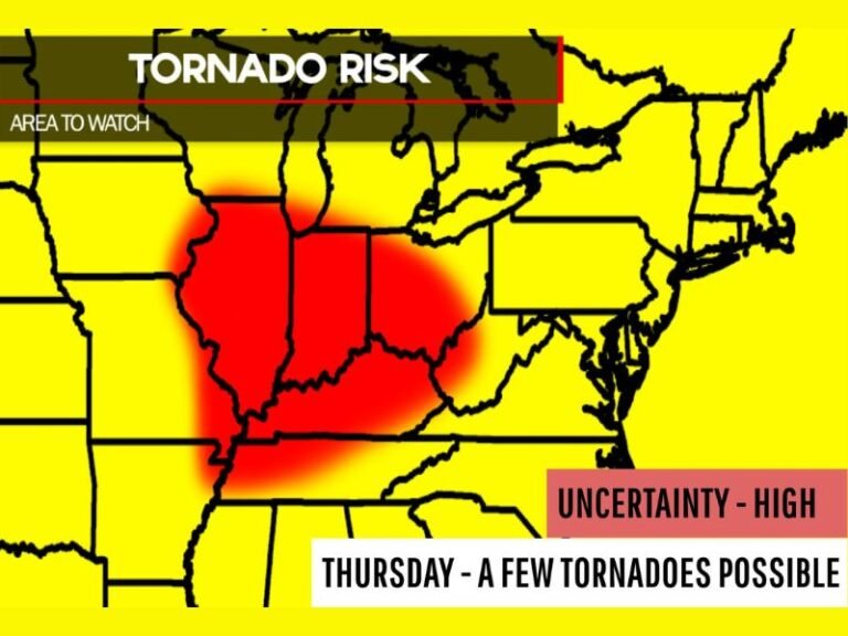
The northern outbreak corridor is the higher-confidence and potentially more violent of the two setups today. The threat zone sits across eastern Iowa, northern Illinois, and southern Wisconsin, where a warm frontal zone and immense low-level shear are creating one of the most favorable EF2-plus tornado environments of the season.
Supercells are expected to fire in northeastern Iowa by 4 PM and quickly develop tornado potential. The warm frontal zone and the low-level shear values in this area are not borderline — they are described as immense, meaning the atmosphere has the raw ingredients to support long-track, violent tornadoes from any supercell that can organize and sustain itself along the boundary.
Northern Mode Risk Zones
| Risk Level | Cities and Areas Covered |
|---|---|
| Enhanced Risk — core orange zone | La Crosse, Milwaukee, Chicago, Des Moines, Fort Wayne, Cleveland, Detroit — upper Midwest and Great Lakes corridor |
| Slight Risk — yellow zone | Minneapolis, Sioux Falls, Omaha, Lincoln, Kansas City, Hannibal, St. Louis, Peoria, Springfield, Indianapolis, Columbus, Pittsburgh, Buffalo, Green Bay |
| Marginal Risk — outer green zone | Fargo, Aberdeen, Bismarck area, broader Plains and eastern states |
The Enhanced Risk core for the northern mode sits directly over the La Crosse, Milwaukee, Chicago, and Des Moines corridor — the exact area where the warm frontal zone, immense low-level shear, and 4 PM supercell initiation in northeastern Iowa all converge into a violent tornado environment.
Northern Mode — Key Cities at Highest Risk
| City | State | Risk Level |
|---|---|---|
| La Crosse | Wisconsin | Enhanced — EF2+ tornado threat |
| Milwaukee | Wisconsin | Enhanced — EF2+ tornado threat |
| Chicago | Illinois | Enhanced — EF2+ tornado threat |
| Des Moines | Iowa | Enhanced — EF2+ tornado threat |
| Fort Wayne | Indiana | Enhanced — EF2+ tornado threat |
| Detroit | Michigan | Enhanced — EF2+ tornado threat |
| Cleveland | Ohio | Enhanced — EF2+ tornado threat |
| Green Bay | Wisconsin | Slight Risk |
| Minneapolis | Minnesota | Slight Risk |
| Sioux Falls | South Dakota | Slight Risk |
| Omaha | Nebraska | Slight Risk |
| Kansas City | Missouri | Slight Risk |
| St. Louis | Missouri | Slight Risk |
| Indianapolis | Indiana | Slight Risk |
| Columbus | Ohio | Slight Risk |
| Pittsburgh | Pennsylvania | Slight Risk |
| Buffalo | New York | Slight Risk |
Southern Mode: Oklahoma Into North Texas — Evening Tornado Threat Ramps Up After Dark
The southern outbreak corridor is a separate and independent tornado threat centered on Oklahoma and North Texas. This mode operates on a different timeline than the northern outbreak — the tornado threat in the south is described as ramping up during the evening magic hour when the low-level jet intensifies.
The evening magic hour is a well-known severe weather phenomenon in the southern Plains. As the sun sets and the boundary layer stabilizes, the low-level jet stream strengthens dramatically, injecting additional wind shear into the environment at the exact level where supercell rotation is most intense. This is the mechanism that makes Oklahoma and North Texas evening tornado setups so dangerous — and it is specifically what forecasters are pointing to as the driver of the southern mode’s peak threat tonight.
Southern Mode Risk Zones
| Risk Level | Cities and Areas Covered |
|---|---|
| Enhanced Risk — core orange zone | Oklahoma City, Tulsa, Woodward, Wichita Falls — the direct supercell and tornado target zone |
| Slight Risk — yellow zone | Lubbock, Amarillo, Abilene, Wichita, Liberal, Garden City, extending into Kansas and southern Missouri |
| Marginal Risk — outer green zone | Broader surrounding areas of Texas, Kansas, and Arkansas |
Southern Mode — Key Cities at Risk
| City | State | Risk Level |
|---|---|---|
| Oklahoma City | Oklahoma | Enhanced — evening tornado threat |
| Tulsa | Oklahoma | Enhanced — evening tornado threat |
| Woodward | Oklahoma | Enhanced — evening tornado threat |
| Wichita Falls | Texas | Enhanced — evening tornado threat |
| Lubbock | Texas | Slight Risk |
| Amarillo | Texas | Slight Risk |
| Abilene | Texas | Slight Risk |
| Wichita | Kansas | Slight Risk |
| Dallas | Texas | Near southern edge |
The southern mode’s tornado threat ramps up in the evening — meaning Oklahoma City, Tulsa, Wichita Falls, and the surrounding area face their most dangerous window after sunset, when the low-level jet kicks in and the atmosphere becomes maximally favorable for supercell tornado development.
Two Timelines — Both Require Immediate Action
| Outbreak Mode | Primary Area | Initiation Time | Peak Threat |
|---|---|---|---|
| Northern mode | Eastern Iowa, northern Illinois, southern Wisconsin | 4 PM | Afternoon into evening |
| Southern mode | Oklahoma into North Texas | Evening hours | After dark — low-level jet driven |
These two timelines mean there is no safe window today across either corridor. The northern outbreak starts at 4 PM and runs through the evening. The southern outbreak starts in the evening and intensifies after dark. Residents in both zones need to be fully prepared before their respective threat windows open — not during.
The EF2-Plus Threat Is the Defining Element of Today’s Northern Mode
The explicit identification of EF2-plus tornadoes as the great threat for eastern Iowa, northern Illinois, and southern Wisconsin elevates today’s northern outbreak above standard severe weather events. The warm frontal zone and immense low-level shear values across this corridor create conditions where long-track, violent tornadoes — not just brief, weak twisters — are the expected storm mode.
An EF2 tornado at minimum carries winds of 111 to 135 mph, sufficient to tear roofs off well-constructed homes, demolish mobile homes completely, and create catastrophic damage across any path it travels. The plus sign means EF3 and above cannot be ruled out from the most extreme supercell in today’s northern outbreak.
What Both Corridors Must Do Right Now
For eastern Iowa, northern Illinois, southern Wisconsin, and the northern Enhanced Risk zone — before 4 PM:
- Identify and get to your tornado shelter — basement or lowest interior room away from windows — before 4 PM when supercells begin firing in northeastern Iowa
- Do not be in a mobile home or manufactured structure during today’s EF2-plus tornado threat window — evacuate to a substantial structure now
- Keep weather radio and phone alerts active through the entire afternoon and evening
For Oklahoma City, Tulsa, Wichita Falls, and the southern Enhanced Risk zone — before evening:
- Know your shelter plan before sunset — the southern mode’s peak threat arrives after dark when the low-level jet intensifies and most residents are winding down for the night
- Keep alerts active overnight — a nighttime tornado warning requires you to already know exactly where to go
- Do not dismiss the southern threat because it comes later — evening and nighttime tornado outbreaks in Oklahoma are historically among the most deadly
Today’s Bimodal Outbreak — Full Summary
| Factor | Details |
|---|---|
| Outbreak type | Bimodal — two simultaneous independent tornado corridors |
| Northern mode location | Eastern Iowa, northern Illinois, southern Wisconsin |
| Northern mode initiation | 4 PM — northeastern Iowa supercell cluster |
| Northern mode key hazard | EF2-plus tornadoes — great threat |
| Northern mode driver | Warm frontal zone and immense low-level shear |
| Southern mode location | Oklahoma into North Texas |
| Southern mode timing | Evening — ramps up as low-level jet intensifies |
| Southern mode key cities | Oklahoma City, Tulsa, Woodward, Wichita Falls |
| Professional response | Live tornado intercept mode activated |
Two Outbreaks, One Day — Both Demand Full Respect
Today is a rare and genuinely dangerous bimodal severe weather outbreak. EF2-plus tornadoes firing across eastern Iowa, northern Illinois, and southern Wisconsin at 4 PM. Oklahoma City, Tulsa, and North Texas facing a ramping tornado threat as the low-level jet intensifies after dark. Professional tornado intercept teams are deploying for both corridors simultaneously — a clear signal of how seriously the meteorological community is treating today’s dual outbreak.
Whether you are in Chicago, Milwaukee, Des Moines, or La Crosse watching the northern mode build from 4 PM — or in Oklahoma City, Tulsa, or Wichita Falls bracing for the southern mode after sunset — today demands your full attention, your shelter plan confirmed, and your alerts active from now until tonight.
Stay with CabarrusWeekly.com for live coverage of both outbreak corridors, tornado reports from the northern and southern modes, and real-time warning updates across Iowa, Illinois, Wisconsin, Oklahoma, and North Texas throughout today’s historic bimodal severe weather outbreak.