Texas, Oklahoma, Arkansas and Missouri Brace for Two-Round Severe Weather Threat March 4 and March 6 as Large Hail and Damaging Winds Lead Early March Risks
TEXAS — A renewed early-March severe weather pattern is taking shape across the southern Plains and lower Midwest, with Wednesday, March 4 and Friday, March 6 highlighted as the highest-confidence days for organized severe storms across parts of Texas, Oklahoma, Arkansas, Kansas and Missouri.
Forecasters indicate a compact upper-level disturbance will interact with a seasonally moist air mass, creating favorable conditions for strong to severe thunderstorms.
Wednesday, March 4: North Texas, Eastern Oklahoma and Western Arkansas in Focus
The first severe weather window centers on north Texas, eastern Oklahoma and western Arkansas.
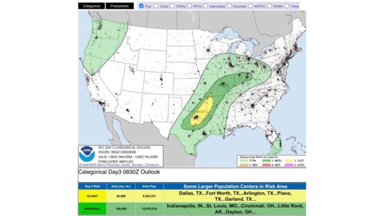
The highlighted corridor stretches from areas near Abilene and Wichita Falls, Texas, northeast through Dallas–Fort Worth, into central and eastern Oklahoma including Oklahoma City, Norman and Tulsa, and extends toward western Arkansas.
Meteorological guidance shows a compact shortwave trough moving into a moisture-rich environment. Surface dewpoints across Texas and Oklahoma are forecast to climb into the 50s and lower 60s, supporting instability development.
At this stage, large hail and damaging straight-line winds appear to be the primary threats. Storm mode details will become clearer closer to the event, but early indicators suggest organized thunderstorm development during the afternoon and evening hours.
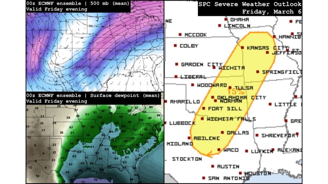
Friday, March 6: Broader Risk from Texas to Missouri
A second system is projected to impact the region on Friday, March 6, with the severe weather corridor expanding northward.
The Friday outlook shows a broader 15% risk area extending from:
Central and eastern Texas
Through Oklahoma and Kansas
Into Missouri
Cities within or near the outlined risk zone include Abilene, Dallas, Waco, Wichita Falls, Oklahoma City, Norman, Tulsa, Wichita, Kansas City and Springfield, Missouri.
Unlike Wednesday’s more focused hail and wind signal, Friday’s setup may support an all-hazards severe weather environment, depending on how instability and wind shear parameters align. This could include:
Large hail
Damaging wind gusts
Isolated tornado potential
The Friday system appears tied to another advancing trough entering the central United States, reinforcing the active early-March pattern.
Active Pattern May Continue into Mid-March
Forecast discussions indicate this is not a one-off event. The broader atmospheric pattern remains supportive of additional severe weather episodes beyond March 6.
Daily storm chances may persist into the second week of March, particularly across the southern Plains and lower Midwest. As additional convective outlooks are issued, intensity probabilities and hazard breakdowns will be refined.
Repeated trough passages, combined with returning Gulf moisture, often increase storm frequency during early spring transitions.
What Residents Should Prepare For
Communities across Texas, Oklahoma, Arkansas, Kansas and Missouri should closely monitor forecast updates through midweek.
Early March severe setups can evolve quickly, especially when upper-level disturbances interact with strengthening low-level moisture. Residents should review severe weather safety plans, particularly in areas within the highlighted risk corridors.
The most immediate concern centers on March 4 and March 6, but additional rounds remain possible.
If you are located in Texas, Oklahoma, Arkansas, Kansas or Missouri and begin noticing changing weather conditions later this week, share your local reports with CabarrusWeekly.com as we continue monitoring this developing severe weather pattern.
Author: Cabarrus Weekly Weather Desk | Category: Weather