Texas, Arkansas, Tennessee and Missouri Face Elevated Tornado Threat Tuesday With Strong Tornadoes Possible Mainly Between 5PM and 10PM
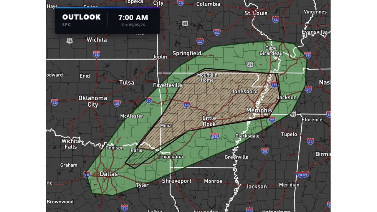
TEXAS, ARKANSAS, TENNESSEE AND MISSOURI — An elevated tornado threat is in place across Texas, Arkansas, Tennessee and Missouri on Tuesday, May 5, 2026, with the risk of a couple of strong tornadoes expected mainly between 5:00 PM and 10:00 PM as the SPC Day 1 outlook issued at 7:00 AM Tuesday defines a hatched tornado risk zone across the core corridor.
Hatched Tornado Risk Zone Covers Arkansas, Tennessee and Northeast Texas
The SPC outlook shows a hatched significant tornado area centered across a corridor from northeast Texas and Texarkana through Little Rock, Jonesboro, Memphis and into western Tennessee. The hatched zone indicates an elevated probability of strong tornadoes within the outlined area.
The broader Marginal to Slight Risk green zone extends the general storm threat across a wider area covering Dallas, Tyler, Shreveport, Springfield MO, Cape Girardeau, Evansville, Tupelo and Greenville.
Peak Tornado Window — 5PM to 10PM Tuesday
The strongest tornado potential is concentrated in the evening hours between 5:00 PM and 10:00 PM. Residents inside the hatched zone across Arkansas, western Tennessee and northeast Texas should be sheltered and have alerts active well before 5:00 PM.
Cities Inside the Elevated Tornado Risk Zone
- Northeast Texas — Paris, Texarkana, Denison
- Arkansas — Mena, Little Rock, Fayetteville, Jonesboro, Mountain Home
- Tennessee — Memphis, Jackson
- Missouri — Springfield, Cape Girardeau
Have multiple ways to receive weather alerts active now. Do not wait for a tornado to be visible before taking shelter.
Stay with CabarrusWeekly.com for live Tuesday tornado threat updates across Texas, Arkansas, Tennessee and Missouri.