Significant Severe Weather Outbreak Possible Friday From Texas and Oklahoma Through Arkansas, Missouri, Illinois and Into the Midwest With Tornado, Large Hail and Damaging Wind Threat
UNITED STATES — A potentially significant severe weather event is taking shape for Friday, March 6, stretching from Texas and Oklahoma northeast through Arkansas, Missouri, Illinois and into parts of the Midwest.
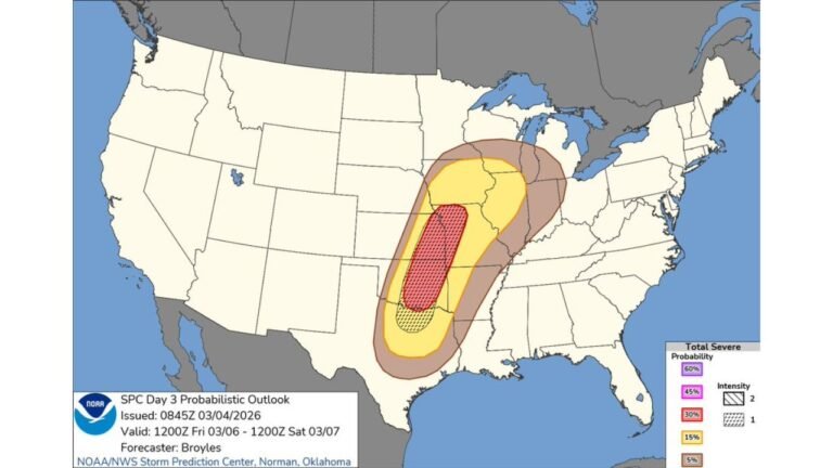
The latest Storm Prediction Center (SPC) outlook shows an organized corridor of severe weather risk developing across the Central and Southern Plains into the Mid-Mississippi Valley, with the possibility of large hail, damaging winds and tornadoes.
Where the Strongest Risk Is Focused
The highest concentration of severe potential currently extends from:
- North and Central Texas
- Central and Eastern Oklahoma
- Western and Central Arkansas
- Much of Missouri
- Into portions of Illinois, Iowa and southern Wisconsin
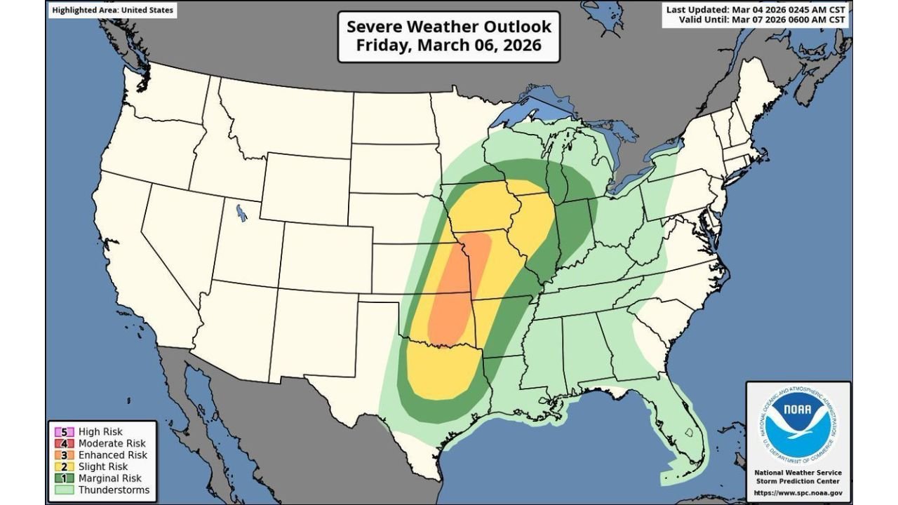
An Enhanced Risk (Level 3 of 5) area is centered from parts of Oklahoma and Arkansas northward into Missouri and southern Iowa, embedded within a broader Slight Risk zone that stretches even farther north and east.
This configuration suggests a corridor where storms could become more organized and intense.
Hazards on the Table
According to the outlook, severe storms developing Friday could produce:
- Large hail
- Damaging wind gusts
- Tornadoes
The combination of strong wind energy aloft, increasing moisture from the Gulf of Mexico and an advancing storm system across the Plains is creating a setup supportive of rotating thunderstorms.
If storms develop as anticipated, the severe threat could become substantial across parts of the Central U.S.
Timing and Evolution
Storms are expected to initiate across portions of Texas and Oklahoma during the day Friday, then spread northeast into:
- Arkansas
- Missouri
- Illinois
- Possibly into the lower Great Lakes region by Friday night
The risk zone suggests that impacts may extend into the evening hours as storms track northeast.
Why This Setup Is Noteworthy
This event stands out because:
- It spans multiple states from the Southern Plains to the Midwest
- It carries a higher-than-average early-season severe signal
- It includes all major severe hazards
While specific storm intensity and track details will continue to evolve, forecast confidence is increasing that Friday could feature a more widespread severe episode across several states.
Stay Alert as Details Refine
Residents across:
- Texas
- Oklahoma
- Arkansas
- Missouri
- Illinois
- Iowa
- Surrounding Midwest states
should closely monitor forecast updates through the week.
As with all severe weather events, exact impacts will depend on storm development and local conditions. However, the current outlook clearly signals that Friday bears watching carefully.
CabarrusWeekly.com will continue tracking forecast updates and provide additional information as new data becomes available.