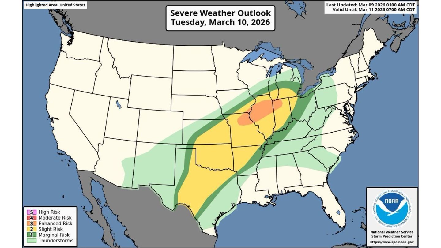
Severe Weather Outbreak Likely Tuesday from Texas Through Missouri, Illinois, Indiana and into Michigan as Tornado and Giant Hail Threat Expands
UNITED STATES — Another widespread severe weather outbreak appears increasingly likely Tuesday, March 10, stretching from Texas northward through Missouri, Illinois, Indiana and into parts of Michigan.
The latest severe weather outlook highlights a broad corridor of risk from the southern Plains into the Midwest, with the most concentrated threat centered across portions of Illinois, Indiana, Missouri, and eastern Texas.
A Multi-State Severe Corridor
The risk area extends from:
- West and central Texas
- Oklahoma
- Missouri
- Illinois
- Indiana
- Into southern Michigan
Within this corridor, a more focused zone of heightened concern is centered over:
- Central and northern Illinois
- Eastern Missouri
- Indiana
Cities near the core of this risk include:
- Peoria, IL
- Springfield, IL
- Chicago, IL
- Indianapolis, IN
- St. Louis, MO
Primary Threats: Hail, Wind and Tornadoes
Forecasters indicate that storms developing Tuesday afternoon and continuing into the evening could produce:
- Very large hail
- Damaging wind gusts
- A few strong tornadoes
The greatest tornado potential appears tied to areas where instability and wind shear overlap most favorably — especially across Illinois, Indiana, and Missouri.
Meanwhile, across eastern Texas and into parts of Oklahoma, storms may also intensify along a dryline setup, bringing the risk of large hail and isolated tornadoes.
Timing: Tuesday Afternoon into Evening
Storm development is expected to begin Tuesday afternoon, likely intensifying through late afternoon and evening as the upper-level system moves east.
The severe threat may continue into the nighttime hours, particularly from the Midwest southward into the southern Plains.
Because this is a multi-state event, timing will vary by region:
- Texas and Oklahoma: Afternoon into evening
- Missouri, Illinois, Indiana: Late afternoon into evening
- Michigan: Evening hours
Why This Setup Is Concerning
This system combines several key ingredients:
- Strong upper-level forcing
- Increasing moisture return
- Sufficient instability
- Robust wind shear
When these factors align across such a large geographic area, widespread severe weather becomes more likely.
The enhanced risk zone centered over Illinois and Indiana suggests that storms in that corridor may become more organized and intense compared to surrounding regions.
Preparation Is Critical
With a severe weather outbreak possible from Texas to Michigan, residents across the highlighted states should:
- Review severe weather safety plans
- Ensure multiple ways to receive weather alerts
- Stay updated on forecast changes throughout Tuesday
Even areas on the edge of the higher risk zone could experience impactful storms if boundaries shift slightly.
Bottom Line
A significant severe weather outbreak is likely Tuesday from Texas through Missouri, Illinois, Indiana and into Michigan. Very large hail, damaging winds and a few strong tornadoes are possible, with the greatest threat centered across parts of Illinois, Indiana, Missouri and eastern Texas.
CabarrusWeekly.com will continue tracking forecast updates as storm timing and boundary placement become clearer ahead of Tuesday’s event.