Louisiana, Florida, Mississippi and Gulf Coast States Eye Rainfall Returns Friday Through Monday as Low Pressure Fuels Southeast Rain Chances
GULF COAST AND SOUTHEAST UNITED STATES — After an extended dry stretch, rain chances are returning to the South and Gulf Coast at the end of this week and into next week, with a low pressure system tied to a frontal boundary expected to funnel moisture from both the western and eastern Gulf of Mexico into the region from Friday through Monday, May 4.
A Two-Phase Rain Event Taking Shape
The setup features two distinct phases driven by Gulf moisture surging northward along a frontal line:
Friday and Saturday — the western Gulf moisture feed becomes active, bringing rain chances to Texas, Louisiana, and the central Gulf Coast.
Sunday and Monday — the focus shifts to the eastern Gulf, increasing rain chances across Florida, Alabama, Georgia, and the Southeast.
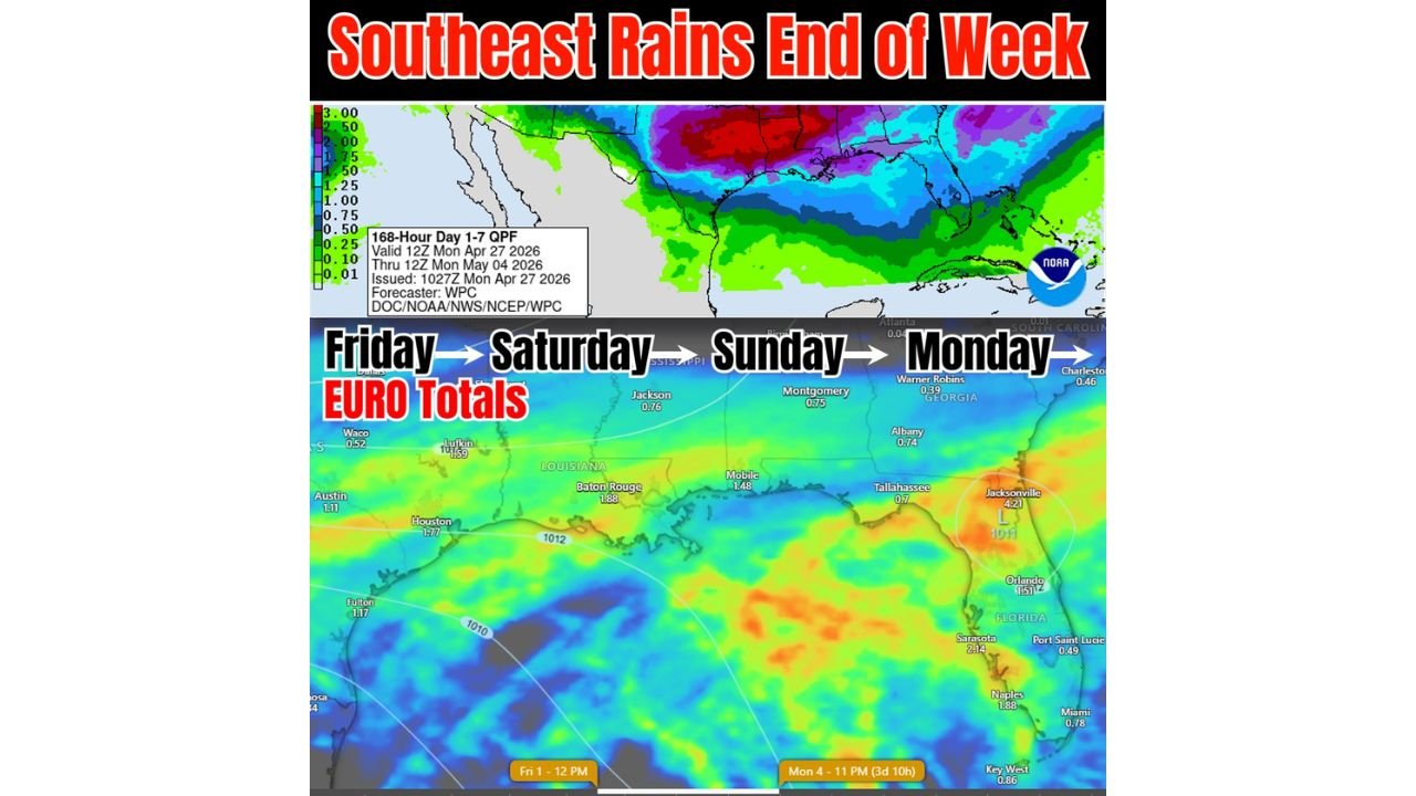
Euro Model Rainfall Totals Friday Through Monday
The European model guidance shows the following projected totals across the region through this period:
| City | Projected Rainfall |
|---|---|
| Jacksonville, Florida | 4.21 inches |
| Sarasota, Florida | 2.14 inches |
| Naples, Florida | 1.88 inches |
| Baton Rouge, Louisiana | 1.88 inches |
| Houston, Texas | 1.77 inches |
| Orlando, Florida | 1.51 inches |
| Mobile, Alabama | 1.48 inches |
| Lufkin, Texas | 1.69 inches |
| Jackson, Mississippi | 0.76 inches |
| Montgomery, Alabama | 0.75 inches |
| Albany, Georgia | 0.74 inches |
| Key West, Florida | 0.86 inches |
| Austin, Texas | 1.11 inches |
| Fulton | 1.17 inches |
| Warner Robins, Georgia | 0.39 inches |
| Tallahassee, Florida | 0.70 inches |
| Charleston | 0.46 inches |
Jacksonville stands out with the highest projected total at over 4 inches, driven by the eastern Gulf low pressure focus during the Sunday and Monday phase.
7-Day QPF Confirms Heavy Rain Axis
The NOAA WPC 168-hour Day 1 to 7 QPF map valid through Monday May 4 at 12Z shows the heaviest rainfall totals concentrated across the northern Gulf Coast into the Tennessee Valley and Carolinas, with a deep purple and red axis indicating 2.50 to 3.00-plus inches across that corridor over the full seven-day period.
Still Some Uncertainty
Forecasters note this remains an evolving setup with some uncertainty in exact track and timing. The European model continues to detect the signal but the precise rainfall distribution from Friday through Monday will come into sharper focus as the week progresses.
Residents across Louisiana, Florida, Mississippi, Alabama, Georgia, and Texas should monitor daily forecast updates through the week as this rain event develops.
Stay with CabarrusWeekly.com for continuing coverage of the developing Southeast rain pattern through the end of the week.