Missouri, Illinois, Kentucky and Indiana Upgraded to Level 4 Moderate Risk as EF3 Tornadoes and Regional Outbreak Loom This Afternoon
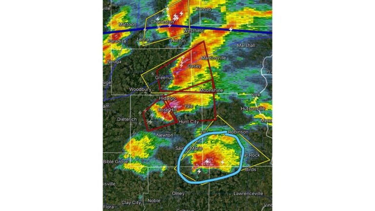
EASTERN MISSOURI AND SOUTHERN ILLINOIS — The Storm Prediction Center has upgraded the tornado risk across eastern Missouri, the St. Louis area, Paducah, and southern and central Illinois to a Level 4 of 5 Moderate Risk today, Monday, April 27, 2026, as a regional severe weather and tornado outbreak looms for the afternoon and evening hours. Significant EF2 and EF3 tornadoes are likely, and an isolated longer-track tornado cannot be ruled out.
Upgraded Risk — Level 4 Moderate Now in Effect
The SPC has drawn a red Level 4 Moderate Risk zone centered on eastern Missouri, St. Louis, Paducah, and southern and central Illinois — a significant escalation from earlier outlooks. This upgrade reflects increasing confidence that the afternoon storm environment will support rotating supercells capable of producing significant, damaging tornadoes.
What Will Drive Tornadoes This Afternoon
Morning thunderstorms are consuming some of the available instability across far northern portions of the region — but plenty of fuel remains across the core risk area. As afternoon heating continues, strong to severe thunderstorms including rotating supercells will develop across the upgraded zone.
The environment features changing winds with height throughout the atmosphere. Any tall thunderstorm that develops in this environment will feel those winds and begin to rotate. That rotation is why tornadoes are likely with the stronger supercells that develop this afternoon.
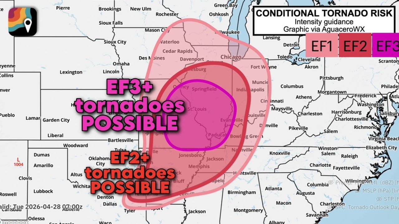
Tornado Intensity Guidance
| Zone | Tornado Intensity Possible |
|---|---|
| EF3-plus zone (hot pink core) | Eastern Missouri, St. Louis, Springfield IL, central Illinois, Paducah, Evansville corridor |
| EF2-plus zone (outer pink) | Southern Illinois, western Kentucky, Arkansas, Memphis area, Jonesboro |
EF2 and EF3 tornadoes are explicitly likely within the highest-risk zone. An isolated longer-track tornado — potentially reaching even greater intensity — cannot be ruled out if a supercell can stay discrete and organize fully.
Act Right Now
If you live across eastern Missouri, the St. Louis metro, Springfield Illinois, Paducah, Evansville, southern and central Illinois, or western Kentucky, you are in the direct path of today’s upgraded tornado threat.
- Get to your shelter location before storms arrive this afternoon
- Have multiple ways to receive tornado warnings active right now
- Do not wait for a tornado warning to be issued before moving to shelter in this environment
- Mobile homes offer zero protection — be in a permanent structure now
Stay with CabarrusWeekly.com for continuous live updates as today’s outbreak unfolds.