Minnesota and Wisconsin Prepare for Potential Season’s Biggest Snowstorm as Twin Cities, Mankato and Eau Claire Face High Odds of 6+ Inches
MINNESOTA — Forecasters are closely monitoring what could become the biggest snowstorm of the season for parts of Minnesota and western Wisconsin this weekend, with impactful snowfall expected Saturday night into Sunday.
According to the latest forecast briefing, most areas are likely to see at least a few inches of snow, while double-digit totals are possible within the band of heaviest snowfall.
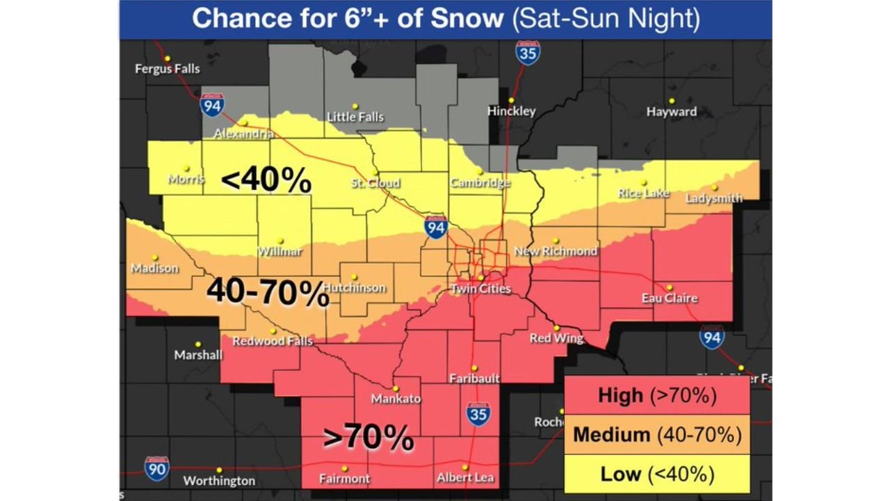
Heaviest Snow Focused Near and Southeast of the Twin Cities
Probability guidance shows a strong signal for significant accumulation across southern and southeastern Minnesota into western Wisconsin.
Areas including:
- The Twin Cities metro
- Mankato
- Faribault
- Albert Lea
- Red Wing
- Eau Claire, Wisconsin
are in the highest probability zone for at least 6 inches of snow.
In fact, portions of southern Minnesota show greater than a 70% chance of exceeding 6 inches. The Twin Cities and nearby communities fall within a 40–70% probability range, while areas farther north — including St. Cloud and toward Little Falls — have lower odds under 40%.
This setup suggests the axis of heaviest snow may stretch from the southern Twin Cities metro southeastward.
Strong Winds Add to the Concern
In addition to accumulating snow, winds are forecast to increase significantly Sunday morning, with gusts reaching 30 to 40+ mph.
These winds could:
- Create blowing and drifting snow
- Reduce visibility in open rural areas
- Increase travel hazards across western and southern Minnesota
Open stretches of highway could experience rapidly changing visibility, especially where snowfall rates are heavier.
Timing: Saturday Night Through Sunday
The storm is expected to develop Saturday evening and intensify overnight into Sunday. Impacts are likely to continue into Sunday afternoon before gradually tapering.
Forecasters caution that while confidence is increasing in impactful snowfall, there remains some uncertainty regarding the exact placement of the heaviest band. Even small shifts north or south could significantly alter who sees double-digit totals.
Planning Timeline
Emergency managers are urging residents to begin preparation now:
A few days out:
- Ensure emergency supplies are stocked for home and vehicle
- Check smoke and carbon monoxide detectors
- Replenish fuel for vehicles and heating sources
The day before:
- Adjust travel plans if necessary
- Have multiple ways to receive weather warnings
- Bring pets indoors and confirm adequate supplies
During and after the storm:
- Avoid travel if possible
- Check on neighbors and family members
- Use generators safely and keep them well away from homes
- Take caution while shoveling heavy snow
Bottom Line
Minnesota and western Wisconsin are facing the potential for a high-impact weekend snowstorm, with the greatest risk for 6 inches or more from the Twin Cities south and east into Mankato and Eau Claire.
Strong winds could amplify impacts, making travel dangerous at times Sunday.
CabarrusWeekly.com will continue monitoring forecast updates as confidence increases and snowfall totals become more refined.