Tennessee, Kentucky and Northern Alabama Facing 75 MPH Wind Threat Sunday Night as Powerful Squall Line Targets Nashville Region
TENNESSEE — A strong cold front is set to barrel across Tennessee, Kentucky and northern Alabama Sunday night, bringing the threat of damaging wind gusts up to 75 mph within a fast-moving line of storms.
Forecasters indicate no major changes to the forecast as of this morning. The primary concern remains widespread damaging straight-line winds, though an embedded tornado threat cannot be ruled out.
75 MPH Wind Gusts Possible in Storm Line
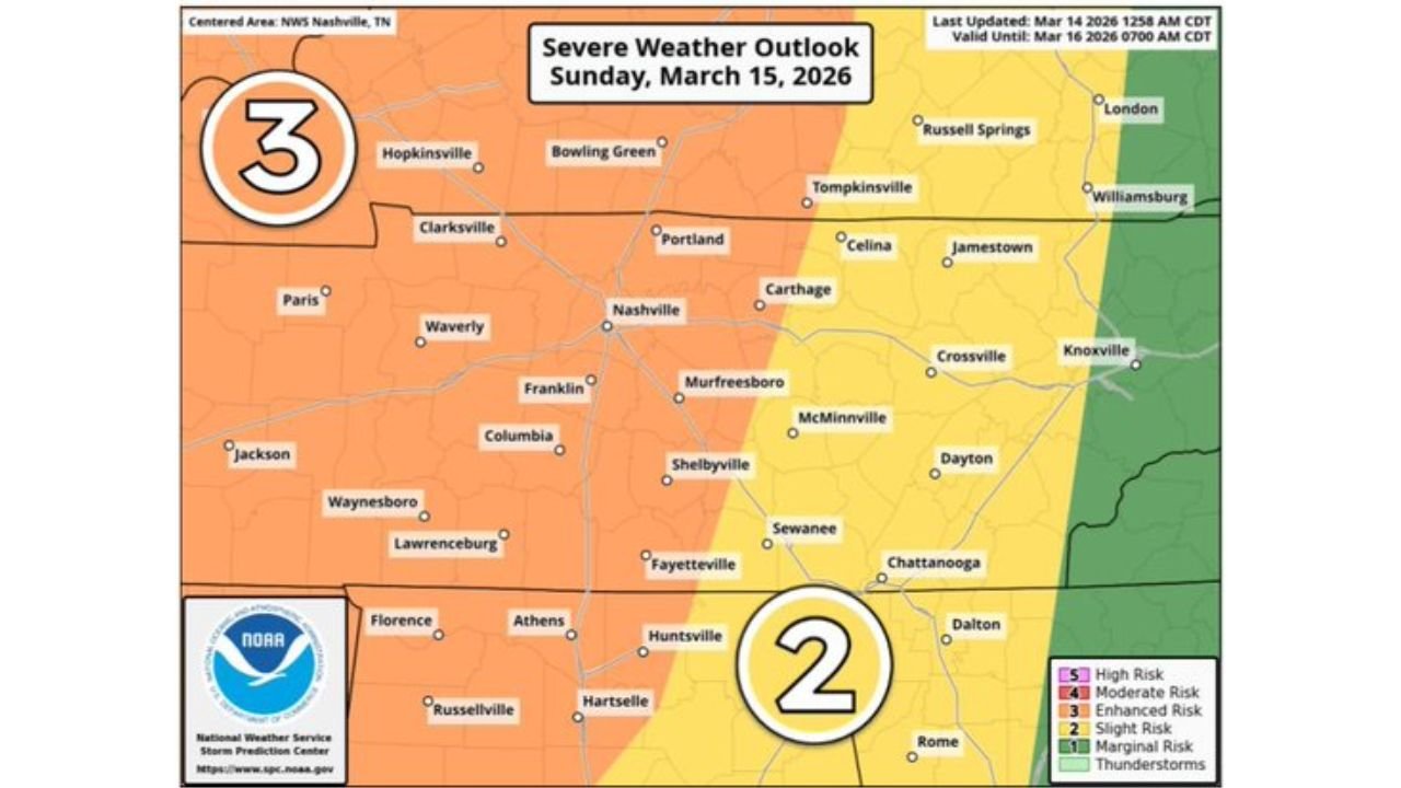
The severe weather outlook places much of central and western Tennessee — including Nashville, Clarksville, Columbia and surrounding communities — under an Enhanced Risk for Sunday evening.
Impacts expected include:
- Damaging wind gusts exceeding 70 mph
- Scattered tree and power line damage
- Isolated structural damage
- Brief, embedded tornado potential
The tornado risk is described as lower than the wind threat but remains present within the squall line.
Target Timing: 8 PM to 11 PM
Current projections are targeting the 8 PM to 11 PM window for the main line of storms across the Nashville region.
Storms are expected to move quickly, reducing the time between warning issuance and impact. Residents should not rely solely on outdoor sirens and are encouraged to have multiple ways to receive weather alerts.
Gusty Winds Outside of Storms
Even outside of thunderstorms, winds will remain gusty Sunday night, with gusts up to 40 mph possible.
These non-thunderstorm winds could:
- Cause minor tree damage
- Make driving difficult, especially for high-profile vehicles
- Compound power outage issues where soils are saturated
Areas of Concern
Communities highlighted in the severe outlook include:
- Nashville and Murfreesboro
- Clarksville
- Columbia
- Bowling Green, Kentucky
- Huntsville, Alabama
The broader severe zone stretches across much of Tennessee into southern Kentucky and northern Alabama.
Preparedness Actions
Given the evening timing of this event, residents should:
- Stay weather-aware Sunday afternoon and evening
- Ensure phones and alerting devices are charged
- Identify a safe location in case a warning is issued
- Secure loose outdoor objects before storms arrive
Even with a lower tornado probability compared to the wind threat, nighttime embedded tornadoes can be especially dangerous due to limited visibility.
Bottom Line
Tennessee, Kentucky and northern Alabama are facing a strong Sunday night severe weather event, with wind gusts up to 75 mph possible within a powerful squall line.
While the tornado threat is lower than the damaging wind threat, embedded tornadoes remain possible. The main window for impacts across central Tennessee appears to be between 8 PM and 11 PM.
CabarrusWeekly.com will continue monitoring forecast updates and provide additional information if timing or intensity changes.