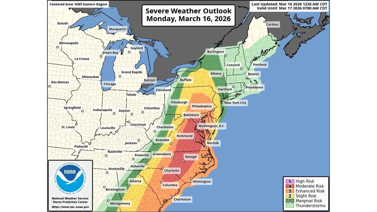
North Carolina, Virginia and Maryland Under Level 4 Moderate Severe Storm Risk Monday With Tornadoes and Widespread Damaging Winds Possible
NORTH CAROLINA — A dangerous severe weather setup is developing across parts of the Southeast and Mid-Atlantic today, with central North Carolina, much of Virginia, and central Maryland placed under a Level 4 Moderate Risk for severe storms.
Meteorologists warn the system could bring tornadoes, including the potential for a few strong or long-tracked tornadoes, along with widespread damaging winds as storms rapidly organize and move east across the region.
The moderate risk area covers cities such as Charlotte and Raleigh in North Carolina, Richmond and Norfolk in Virginia, and Baltimore and Washington DC in Maryland and the District of Columbia.
Parts of South Carolina also fall within the broader severe weather zone as storms track northeast along the East Coast.
Tornado Threat Exists Across the Carolinas and Virginia
Forecasters say the primary concern today will be tornado development within fast-moving thunderstorms, particularly from central North Carolina north through Virginia and into Maryland.
The environment could support rotating supercell thunderstorms, which are capable of producing tornadoes.
Meteorologists indicate that one or two storms could produce stronger, longer-tracked tornadoes, especially if storms are able to remain isolated before merging into a larger storm line later in the day.
Damaging Winds Expected to Be the Most Widespread Hazard
While tornadoes are a major concern, forecasters say damaging wind gusts may become the most widespread impact as storms grow more organized.
As thunderstorms consolidate into a stronger line of storms, powerful winds could spread across large areas as the system pushes eastward through the afternoon and evening.
This type of storm structure can produce widespread tree damage, power outages, and hazardous travel conditions as strong wind gusts move across communities.
Atmospheric Setup Favoring Strong Storm Development
The severe weather risk is being driven by a strengthening weather pattern across the eastern United States.
A powerful disturbance moving through a larger upper-level trough is expected to intensify as it travels north near the Appalachian Mountains later today and tonight.
At the same time, moisture is rapidly returning northward, helping fuel instability across the Carolinas and Mid-Atlantic region.
Meteorologists note that strong wind fields and intense low-level wind shear will create favorable conditions for rotating thunderstorms capable of producing severe weather.
Afternoon and Evening Storm Window Most Dangerous
The most dangerous period for severe storms is expected during the afternoon and evening hours, when atmospheric instability increases.
If early-day storms do not disrupt the warm and humid air mass too much, the environment could support fast-moving supercells ahead of a larger storm line later in the day.
These storms may initially develop as isolated rotating thunderstorms before eventually forming a more organized line of storms capable of producing widespread wind damage.
Large Portion of the East Coast in Severe Weather Zone
The broader severe weather outlook stretches from Georgia and South Carolina through North Carolina and Virginia into Pennsylvania and parts of New York, though the most significant threat is centered farther south.
Cities including Greensboro, Charlotte, Raleigh, Richmond, Washington DC, and Baltimore are all located within or near the higher risk zones.
Residents across the region are urged to stay alert for rapidly changing weather conditions and possible severe thunderstorm or tornado warnings as storms develop later today.
Stay with CabarrusWeekly.com for the latest updates as meteorologists track this dangerous severe weather outbreak across North Carolina and the Mid-Atlantic region.