Texas, Illinois, New York and Midwest Hit by Widespread Freeze as Arctic Air From Canada Impacts Over 180 Million Americans
UNITED STATES — A massive surge of Arctic air has swept across the country, leaving more than 180 million Americans waking up to freezing temperatures Tuesday morning, stretching from Texas and Oklahoma through the Midwest and into parts of the Northeast including New York.
The widespread cold snap marks one of the largest late-season freezes in recent weeks, covering a significant portion of the central and eastern United States.
Freezing Temperatures Stretch Across Central and Eastern U.S.
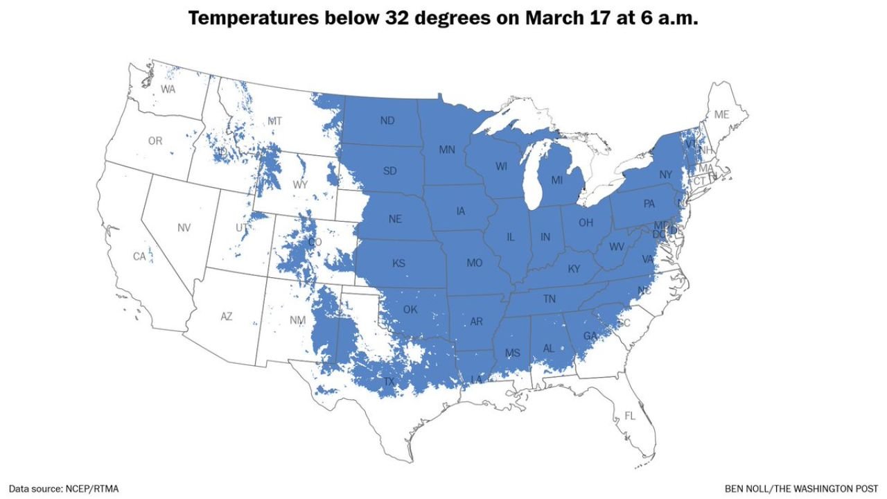
Early morning data shows temperatures dropping below 32°F across a broad region, including:
- Texas and Oklahoma
- Kansas, Missouri, and Arkansas
- Illinois, Indiana, and Ohio
- Tennessee and parts of the Southeast
- Pennsylvania, New York, and surrounding Northeast states
This widespread freeze impacted both urban and rural areas, with millions experiencing sub-freezing conditions at the same time.
Arctic Air Mass Traced Back to Canada
The cold air currently over the United States originated from far north in Canada’s Northwest Territories, where it was positioned roughly 10 days ago before beginning its journey south.
Tracking data shows the air mass moving:
- From northwestern Canada
- Through the Canadian Prairies
- Into the Great Lakes region
- Then diving south and east toward areas including Washington, D.C. and the Mid-Atlantic
This long-distance movement allowed the cold air to remain intact, delivering a sharp temperature drop across much of the U.S.
Midwest and Plains See Most Widespread Cold Coverage
The core of the cold air settled across the Midwest and central Plains, where the largest continuous area of freezing temperatures was observed.
States like Iowa, Nebraska, South Dakota, and Minnesota experienced especially widespread coverage of sub-freezing readings, with cold air extending southward into parts of Texas.
Southeast and North Carolina Also Feel the Chill
While not as intense as the Midwest, parts of the Southeast, including North Carolina, South Carolina, and Georgia, also saw cooler conditions and pockets of near-freezing temperatures early in the day.
For residents in Cabarrus County and surrounding areas, the cold was noticeable but less severe compared to regions farther north and west.
Sudden Temperature Drop Highlights Volatile Spring Pattern
This cold outbreak comes amid a highly variable weather pattern across the United States, where rapid swings between warm and cold conditions are becoming more frequent.
The sharp contrast between recent warmth and this widespread freeze highlights the unpredictable nature of late winter and early spring weather transitions.
What Comes Next
As the cold air mass gradually shifts eastward and moderates, temperatures are expected to rebound in many areas over the coming days.
However, the broader pattern suggests that additional swings in temperature — including both warm surges and cold snaps — remain possible in the weeks ahead.
For now, millions across the country are dealing with the immediate impacts of a large-scale freeze driven by Arctic air straight from northern Canada.
Stay with CabarrusWeekly.com for continued updates on changing weather conditions across North Carolina and the United States.