North Carolina, Pennsylvania, New Jersey Among East Coast States Hit by Widespread Wind Damage as Storm Line Brings Embedded Tornado Threat
NORTH CAROLINA — A powerful line of storms swept across the Eastern United States, leaving behind widespread wind damage from North Carolina through Pennsylvania and New Jersey, while also producing isolated tornado activity along the corridor.
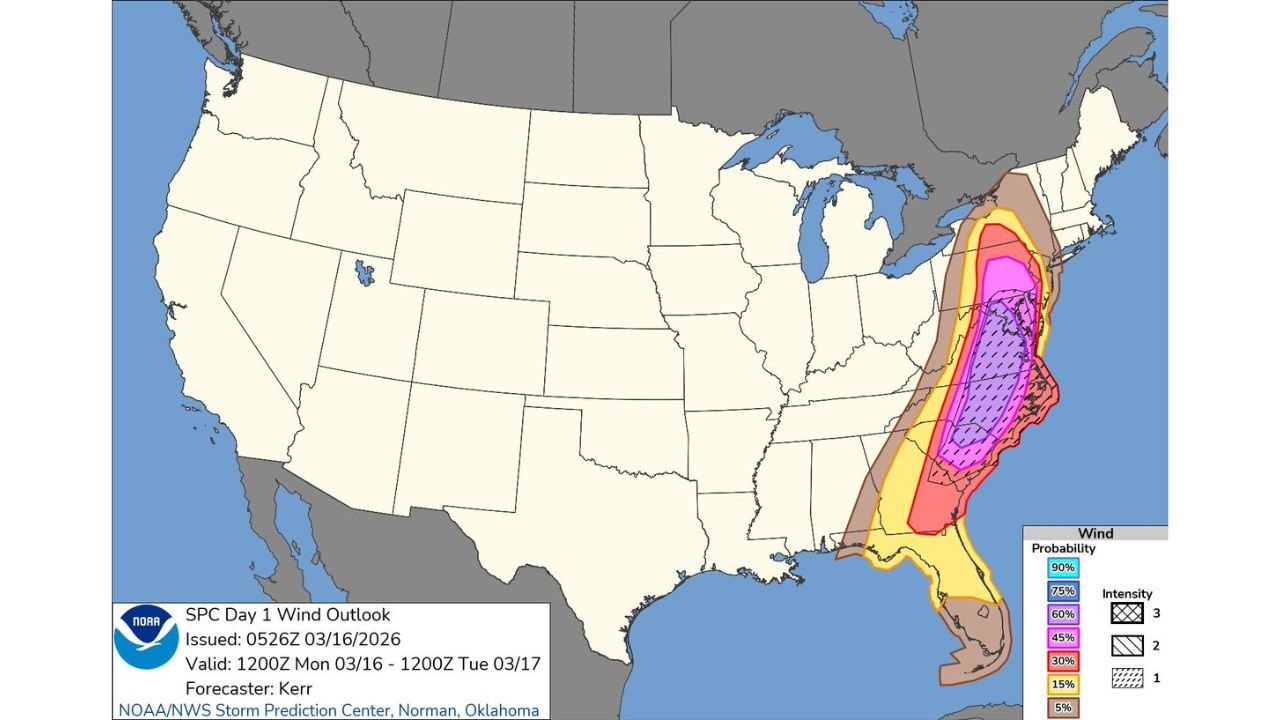
The system impacted a heavily populated stretch of the East Coast, where more than 22 million people were within a significant wind risk zone, amplifying the scale of reported damage.
Wind Damage Reported Across Multiple East Coast States
The storm line tracked northward from the Southeast into the Mid-Atlantic and Northeast, affecting:
- North Carolina
- Virginia
- Maryland
- Pennsylvania
- New Jersey
Numerous reports of downed trees, scattered structural damage, and power outages were recorded as the line pushed through these states.
While many of the reports were based on observed damage rather than instrument-confirmed readings, the impacts were still widespread and disruptive.
Wind Gusts Mostly Below Severe Thresholds but Still Impactful
Preliminary information suggests that many wind gusts associated with the storms were likely in the 40 to 55 mph range, which is generally below the official severe thunderstorm criteria.
However, even at those speeds, the storms were strong enough to:
- Snap tree limbs
- Bring down power lines
- Cause localized property damage
This resulted in a high volume of damage reports despite wind speeds not consistently reaching extreme levels.
Embedded Tornadoes Likely Within the Storm Line
Although a more significant, long-track tornado outbreak did not fully materialize, conditions along the line were still favorable for embedded tornadoes.
Reports indicate that several brief tornadoes may have developed within the storm system, particularly from the Carolinas through parts of the Mid-Atlantic.
This aligns with a 5% to 10% tornado risk zone that had been outlined across the region, which can still produce multiple short-lived tornadoes.
High Population Density Amplified the Impact
The East Coast’s dense population played a major role in the volume of reports and overall impact.
Even moderate wind events can generate large numbers of damage reports when they move through urban and suburban areas, leading to:
- Increased emergency calls
- Higher visibility of storm impacts
- More widespread disruptions compared to less populated regions
Storm System Falls Short of Extreme Expectations but Still Causes Disruptions
While earlier concerns included the potential for a more severe, supercell-driven outbreak, the event evolved primarily into a linear storm system, limiting the scale of extreme tornado activity.
Still, the combination of strong winds, isolated tornadoes, and widespread exposure across major population centers made this a significant weather event across the East Coast.
What It Means for North Carolina and Surrounding Areas
For North Carolina, including communities like Cabarrus County, the storm served as a reminder that even non-extreme storms can create meaningful impacts, especially when they move through populated regions.
Residents experienced:
- Brief periods of intense wind
- Localized damage
- Rapid storm movement with limited warning time
As cleanup continues across affected areas, attention now shifts to monitoring additional systems that could follow similar tracks in the coming weeks.
Stay with CabarrusWeekly.com for continued updates on severe weather impacts and forecasts affecting North Carolina and beyond.